Sunny skies in Philadelphia region Monday, heating up for the Fourth of July
PHILADELPHIA (CBS) — It's an unbelievably beautiful Monday in the Philadelphia region, with sunny skies from start to finish, low humidity and a light northwest breeze. Highs today will be in the upper 70s to low 80s, which is actually below average for the time of year.
We'll continue that pleasant sunny trend on Tuesday and Wednesday, with slightly higher temperatures and mostly sunny to partly cloudy skies.
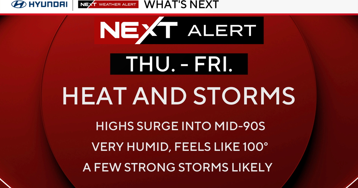
By Thursday, the Fourth of July, it will be muggy and hot with highs in the low 90's and a feel-like nearing 100. Another Heat Advisory and NEXT Weather Alert may be needed for Thursday.
Showers and storms are also possible for the holiday Thursday, although these may be very widely scattered. At this point, don't cancel any Fourth of July plans, but keep an eye on the sky.
The pattern of heat, humidity and afternoon storms will continue through the weekend with highs in the low 90s, morning lows in the 70s and shower or storm chances each day.
As of now, it looks as though Friday may be the most active and Sunday the least, but we'll keep you posted on that.
In the tropics, Hurricane Beryl is bringing life-threatening storm surge flooding and catastrophic wind damage to the Windward Islands today as a Category 4 hurricane. Beryl will remain a dangerous hurricane through the end of the week and may make a close pass to Jamaica on Wednesday before threatening the Yucatan Peninsula on Friday.
Keep it close to CBS Philadelphia as we continue to monitor the tropics and forecast for the upcoming holiday and holiday weekend.
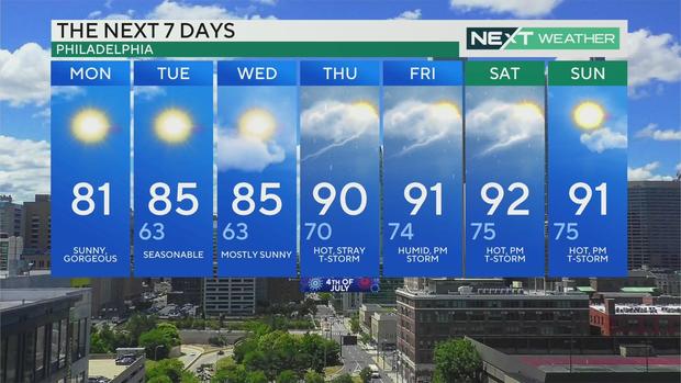
7-day forecast
Monday: High of 81, sunny, gorgeous
Tuesday: High of 85, low of 63, seasonable
Wednesday: High of 85, low of 63, mostly sunny
Thursday: High of 90, low of 70, hot, stray thunderstorm
Friday: High of 91, low of 74, humid, p.m. storm
Saturday: High of 92, low of 75, hot, p.m. storm
Sunday: High of 91, low of 75, hot, p.m. thunderstorm