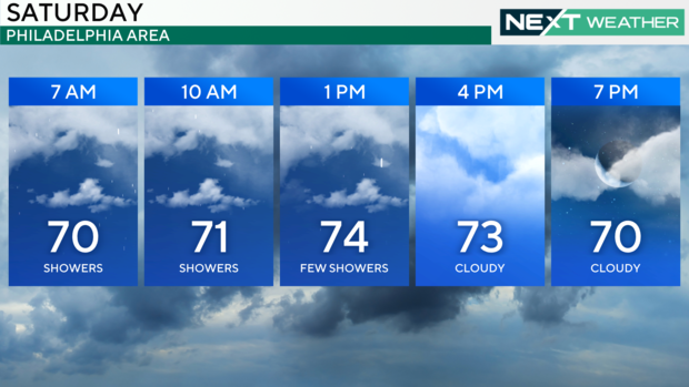
Showers early Saturday morning in Philadelphia, humidity and some sun
The next several days will bring similar conditions, day in and day out.
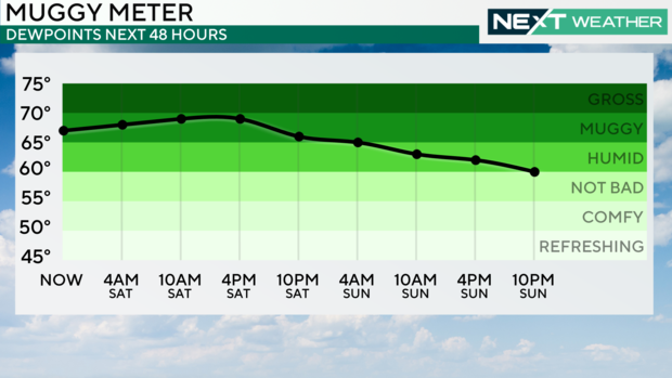
That means mostly cloudy skies, off-and-on showers and humid conditions as the moisture from Helene heads this way.
The center of Helene is drifting westward Saturday and will not fully clear the East Coast until at least Tuesday of next week, keeping us in a cloudy, unsettled pattern.
Helene, now just remnant moisture, is staying over the Mississippi Valley on Saturday but outer bands of clouds and showers will lift far enough north to impact our area through the weekend with off and on rain showers, cloudy skies and sticky air.
Helene will slowly drift through the eastern half of the country through the early part of next week.
This means that while none of our days from Saturday on look like washouts, we'll keep it cool and cloudy with shower chances each day [possibly peaking on Tuesday] until a cold front brings a much-needed pattern change by the middle of next week.
The NEXT Weather team will continue to monitor this storm as well as any other chance of rain through the week to help you plan for any potential impacts.
Here's your 7-day forecast:
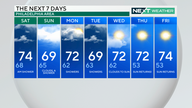
Saturday: A.M. shower. High 74, Low 68
Sunday: Clouds, a shower. High 69, Low 65
Monday: Showers. High 72, Low 62
Tuesday: Showers. High 69, Low 63
Wednesday: Clouds to sun. High 72, Low 63
Thursday: Sun returns! High 72, Low 53
Friday: Sun returns. High 74, Low 53