Pleasant, less humid weather in Philadelphia area after storms move out; patchy morning fog possible

PHILADELPHIA (CBS) — After a Wednesday night filled with heavy rain, gusty winds and severe thunderstorms, we are looking toward a much brighter and calmer end to the week.
A few leftover showers, sprinkles and clouds will greet us Thursday morning with temperatures in the 60s and 70s across the Delaware Valley. We'll see some lingering clouds, maybe some patchy fog, that will all break up as the morning goes on.
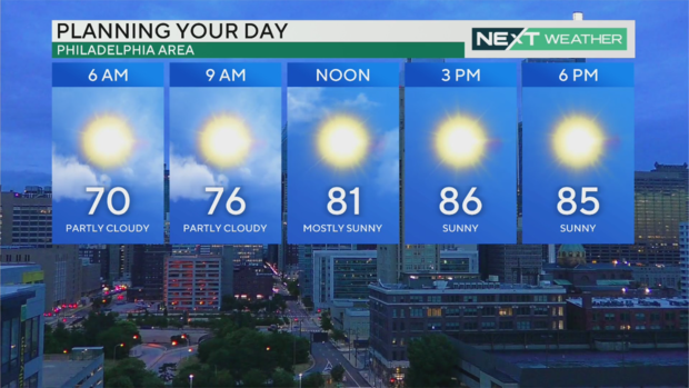
By the middle of the afternoon, if not earlier, we should be seeing sunshine with temperatures approaching the mid and upper 80s.
Despite the warmth, winds out of the northwest will allow conditions less humid and much more comfortable.
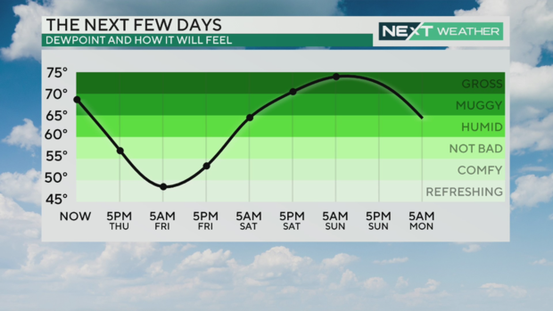
The dew point will slowly drop as the cold front that brought us the storms fully moves through. We're finally getting a break from the high humidity we saw during the heat wave and on Wednesday, though it will be brief. Dew points dip down to comfortable levels Thursday night into Friday morning.
That's going to make Friday even nicer than Thursday, with plenty of sunshine from start to finish and a high of 83. The pleasant temperature and a light breeze mean it'll really be a banner day to get outside and maybe do some outdoor activities — go for a walk, dine outside with friends and family, watch a movie outdoors.
After days and days of feels-like temperatures in or near the triple digits, it's nice to see the heat index tracker doesn't get above 90 for the next couple days.
Weekend watch
Heat and humidity, along with clouds, return by Saturday with a chance for a scattered storm. While Sunday is still a few days away, we are looking toward the afternoon and evening to provide us with a chance of showers and thunderstorms.
The high by Sunday afternoon will be around 90 degrees but could feel closer to 100 with the return of high humidity. We could have the chance for a strong thunderstorm later in the day Sunday.
Stay with the CBS News Philadelphia NEXT Weather alert team as we continue to track the ever-changing weather.
Here's your 7-day forecast:
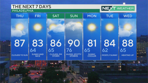
Thursday: High of 87, low of 73, clouds to sun
Friday: High of 83, low of 64, bright and sunny
Saturday: High of 86, low of 65, very warm, storms possible
Sunday: High of 90, low of 76, steamy and thunderstorms
Monday: High of 81, low of 65, a nice start to July
Tuesday: High of 84, low of 62, sunny skies
Wednesday: High of 88, low of 65, mostly sunny