Tornado watch across Philadelphia area lifted as Debby moves north. Tracking weather warnings and alerts

PHILADELPHIA (CBS) --The National Weather Service canceled a tornado watch that was previously in effect for parts of the Philadelphia region until 10 p.m. as the remnants of Debby head north of our region.
However, this doesn't mean tornados can't happen, instead just that the overall conditions do not favor it happening. The watch is still in effect for parts of North Jersey and beyond.
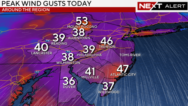
The NWS Mount Holly's local storm report from just after 5 p.m. found non-thunderstorm wind damage throughout Pennsylvania and New Jersey resulting in uprooted and snapped trees, downed power lines, or utility poles leaning against wires leading to road closures and power outages.
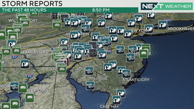
Among some of the recent findings from the report were uprooted and snapped trees in Montgomery County; broken tree limbs in Burlington County, and downed power lines at the intersection of Hilltop Road and Friend Drive in Chester County.
The NWS Storm Prediction Center first issued the alert Friday morning for the entire region. The initial watch was issued for the entire region until 2 p.m. and later extended for parts of the region until 10 p.m.
What is a tornado watch and what is a tornado warning?
A tornado watch means there are conditions favorable for a tornado to form, like possible rotation in the atmosphere. A watch means people in the affected area should be on the lookout for further developments, like a tornado warning.
A tornado warning means a tornado has been spotted or detected on weather radar, and people in the affected area should take shelter.
Our region has already seen one confirmed tornado this week — in New Castle County, Delaware, an EF-1 tornado tore off part of the roof of an Acme grocery store Thursday night, scattering tree limbs and damaging the cart return at the store. No injuries were reported. The store is closed today because of the damage.
Make sure to have a safe space in mind in case of a tornado warning for your area. If you have a basement in your home, that is likely the safest place. "Put as many walls between yourself and the outside as possible," the NWS recommends. Other options could be small interior spaces like a bathroom, closet or enclosed hall on the lowest floor of a building.
Debby's path shows worst rain arrives in afternoon
Debby was downgraded from a tropical storm to a tropical depression and then a post-tropical cyclone overnight but will still pack plenty of rain and some severe storm risk for the area.
New Jersey's Lt. Gov. Tahesha Way declared a State of Emergency in the Garden State effective 6 p.m. Friday ahead of severe storm impacts including heavy rain, high winds and flash flooding.
We've been tracking the storm's path all week, and it looks like the bulk of the rain will fall on central Pennsylvania. However, we'll still see plenty in eastern Pennsylvania, New Jersey and Delaware.
The region will see at least 1 to 2 inches of rain, but anywhere with a scattered downpour overhead could see a higher rainfall total.
Some scattered downpours were already arriving Friday morning to kick off a long, wet day for the region.
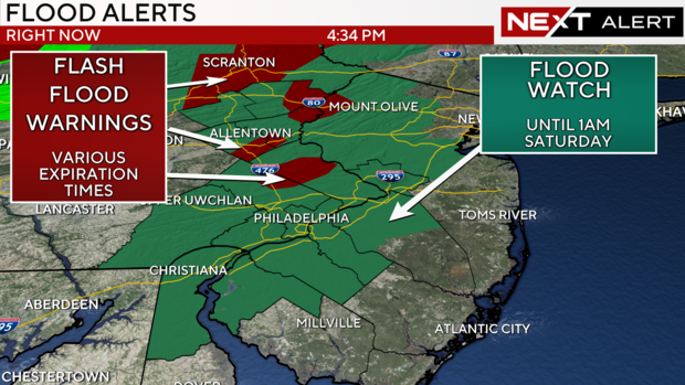
Severe weather risk, flood watch in Philadelphia area
Debby's arrival will lead to multiple weather alerts across Pennsylvania, New Jersey, and Delaware today. A flood watch is in effect until 1 a.m. Saturday.
A flash flood warning is in effect for east central and southeast Pennsylvania, including Berks, Lehigh, Bucks and Montgomery counties until 1 a.m. Saturday.
There is a flood warning for the Brandywine Creek at Chadds Ford, Pennsylvania, where the water level was above the minor flood stage, data from the NWS and National Oceanic and Atmospheric Administration's National Water Prediction Service shows.
Along the Delaware River, a coastal flood advisory is in effect from 4 p.m. Friday until 10 p.m.
The affected areas include Gloucester, Camden and northwestern Burlington counties in New Jersey and Philadelphia, Delaware, and Lower Bucks counties in Pennsylvania.
The Delaware River was already reaching a minor flood stage at the monitoring station at Washington Avenue in Philadelphia, during Friday morning's high tide, per the NWS and NOAA data.
The monitoring station in Burlington, New Jersey, also showed the river above the minor flood stage.
Stay with the NEXT Weather team here at CBS News Philadelphia as we continue tracking Debby and its effects on the area.
This is a developing story and will be updated.