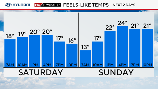
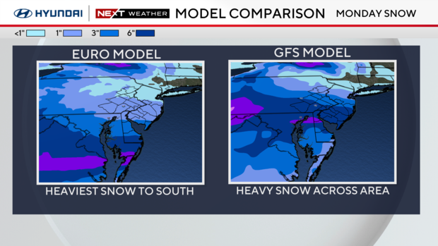
Snow on Monday looks to impact points south of Philadelphia the most; weekend feels-like temps in the teens
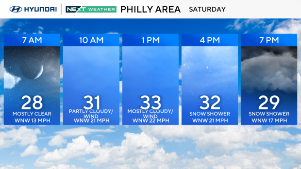
Temperatures are plummeting in the Philadelphia region Saturday after some brief snow showers Friday. Expect the weather to get very cold with lows in the 20s and highs barely above freezing.
This is all setting the stage for a potential snowstorm Sunday night into Monday. We have a NEXT Weather Alert in place for the potential of widespread snowfall.
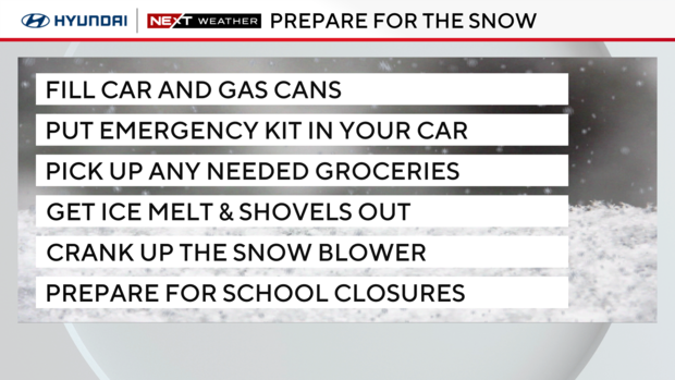
Be sure to take advantage of the dry conditions over the weekend to prepare for Monday's chance at our first significant snow of the season by getting your fuels, ice melt/shovels, turning on your snow blowers, preparing for school closures, etc.
Mayor of Philadelphia, Cherelle Parker, advised drivers to avoid any unnecessary travel during the storm. However, if you find yourself out on the roads, Parker advises drivers to use caution.
The Philadelphia Streets Department pre-treated major roadways on Saturday to help prevent any ice from forming a bond with the ground during the early stages of the incoming storm.
How much snow will we get Monday? It depends on the storm's track.
It's still uncertain exactly how much snow we'll get as it all depends on the ultimate track of the storm. But the National Weather Service has placed much of the Philadelphia region under a winter storm watch for Sunday evening into Monday morning.
The areas under the alert run as far north as Trenton and onward south. Areas like the Lehigh Valley and Poconos, Berks County, Bucks County and Upper Montgomery County have not been included in this alert.
If the track for the storm runs farther south, it will mean less snow, and farther north will ramp the totals significantly.
This storm has widespread 2-inch-plus potential and depending on the track, could produce 3-6 inches in parts of the area.
We'll likely have a clearer idea of the track Saturday night into Sunday morning. Either way, it's looking like South Jersey and Delaware would receive more snow than those northern points.
For now, it's looking like snow will develop around 3 a.m. to 5 a.m. and we could see steady snow over Philadelphia and the I-95 corridor from 7 a.m. to 11 a.m.
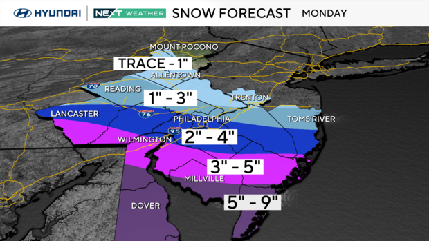
We did some preliminary estimates of snowfall based on how the track looks right now. Remember, this outlook could change, and these bands could shift north or south in accordance with the storm's track.
There will be a sharp gradient in snowfall from the southern parts of our region to the north. We could have viewers in Delaware making snow angels and Lehigh Valley viewers wondering what the fuss was about!
The graphic above shows a band of the heaviest snow across the southern half of Delaware through Cape May, southern Atlantic and southern Cumberland counties in New Jersey. These areas could receive 5 to 9 inches of snow.
Above that is a band cutting through southern Chester County in Pennsylvania, New Castle County in Delaware and parts of Salem, Gloucester and northern Atlantic counties in New Jersey. These areas could get 3 to 5 inches of snow.
The next band is over northern Chester County, Philadelphia County and lower Montgomery County in Pennsylvania, and northern Gloucester, Camden and Burlington counties in New Jersey. We're looking at a possible 2 to 4 inches of snow here.
Getting farther north of Philadelphia, we could see a band dropping about 1 to 3 inches of snow over areas like Berks County and Upper Montgomery County in Pennsylvania, and western Burlington County in New Jersey.
The farthest points north could only get a trace to an inch of snow. Those areas are Bucks County, the Lehigh Valley, Mercer County and the Poconos.
By the way, it looks like this will be lighter, fluffy snow, good for making snowmen and snowball fights.
The NEXT Weather Team will continue to monitor this system and continue to bring you the latest, keeping you prepared and protected for the Monday commute.
What's next after Monday
After Monday, we dive into an extremely cold pattern, likely staying below freezing for a stretch of 4-7 days. It's likely that precipitation that falls will stay frozen overnight, and surfaces with some melted snow on them could re-freeze overnight. Stairways, stoops, walkways and roads could be very slippery into Tuesday.
That means very little of the snow that falls will be melting any time soon.
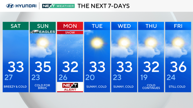
Here's your 7-day forecast:
Saturday: Breezy and cold. High 33, Low 27.
Sunday: Cold for Birds. High 35, Low 23.
Monday: NEXT Alert: snow. High 32, Low 26.
Tuesday: Sunny, cold. High 33, Low 20.
Wednesday: Sunny, cold. High 33, Low 23.
Thursday: Cold continues. High 32, Low 19.
Friday: Still cold. High 36, Low 24.
