Seasonable temperatures return to Philadelphia region this week, storms possible
PHILADELPHIA (CBS) — The Philadelphia region is back to a typical summer pattern Sunday with sunshine, highs near 90 and increasing humidity. Isolated showers are also possible Sunday afternoon.
The storm system south of us that brought clouds Saturday will head offshore, and high pressure to our west will keep us clear of bad weather Sunday.
Monday it will be partly sunny with scattered showers and storms later in the day and continuing overnight into early Tuesday.
Big changes to our weather pattern arrive Tuesday evening with a parade of systems bringing rain and storm chances each day through Thursday. Be aware that some of these storms could be gusty with heavy rainfall. Consider this your official umbrella alert.
Temperatures this week will hover in the mid to upper 80s with higher humidity leading to a very muggy stretch.
The massive heat dome which has gripped the nation since mid-June has shifted back to the southwest and west coast stretching from Seattle to San Diego. That heat will be headed our way by next weekend when another heatwave is possible across the Delaware Valley with temperatures again in the 90s into the following week.
The Climate Prediction Center has placed Philadelphia in a slightly warmer than normal pattern through the end of the month and a much warmer than average outlook for August, September and October. For context: Every month since November has been warmer than average in Philadelphia, and July will be added to that streak.
The severe weather pattern so prevalent over much of the nation and certainly here in Philadelphia has also quieted down, leaving us with mainly non-severe storms this week. That said, any storm could turn briefly severe if the conditions are favorable, so stay aware and updated with our Next Weather Alert Team.
Speaking of wet weather, the Climate Prediction Center has outlined the Delaware Valley in an above-average precipitation outlook for the next three months starting in August and ending in October.
Finally, the tropical Atlantic continues to be in an eerily quiet pattern and that will continue through next week. As we enter August, that is expected to shift into a more active pattern of storm development. Speaking of the Atlantic, there is a large plume of Saharan dust crossing the Atlantic which has reached Florida and will linger through mid-week. Some very pretty sunsets are possible in the Sunshine State this week.
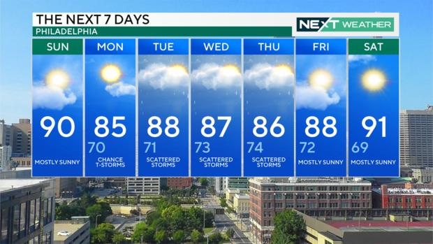
7-day forecast
Sunday: High of 90, mostly sunny
Monday: High of 85, low of 70, chance of thunderstorms
Tuesday: High of 88, low of 71, scattered storms
Wednesday: High of 87, low of 73, scattered storms
Thursday: High of 86, low of 74, scattered storms
Friday: High of 88, low of 72, mostly sunny
Saturday: High of 91, low of 69, mostly sunny
