Phillies home opener: Outlining timeline of potential storms
PHILADELPHIA (CBS) -- Summer-like temperatures are making their way into the Delaware Valley this week, with 80-plus degree highs expected Thursday afternoon, but the Philadelphia Phillies' home opener is expected to be impacted by thunderstorms.
You know the old saying, "What goes up, must come down"? That's the perfect way to describe our end-of-week forecast, with a powerful cold front sweeping through late Thursday.
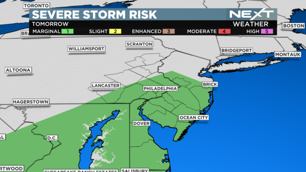
Severe weather along this front is likely to impact the entire area, which is why Thursday is a NEXT Weather Alert Day.
Timing of the front
Thursday morning may once again start off with patchy fog, so keep that in mind for the early commute. Once we make it past 9 a.m., strong south winds ahead of the approaching front will develop, and help bring in very warm temperatures.
Midday numbers will be in the 70s for many spots, including the city of Philadelphia. Along with that, add in some sunshine, which will brighten the day up, sure but also increase the instability in the atmosphere, ensuring that severe weather will break out later in the day.
Gates for the Phillies' home opener open at 12:35 p.m. For anyone lining up to be one of the first in, it'll be breezy, warm and muggy. Most importantly, it will be dry.
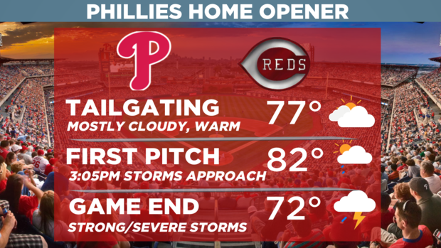
The challenge with this forecast is the timing of the cold front moving through the city. If it speeds up even a little and comes through earlier (1 to 2 p.m.), there's at least a chance that severe storm development would be limited, and the game could even start on time.
Looking at the freshest information, the most likely scenario is that it comes through between 3 p.m. and 5 p.m., seriously jeopardizing the start and even completion of the game.
By 7 p.m., we'd be dealing with leftover showers, while the line of severe storms would be moving through central and southern New Jersey.
By 9 p.m. to 10 p.m., the front is likely to be moving off the Jersey Shore and out to sea.
Severe impacts
Since this is a fast-moving system, damaging winds will be the most likely form of severe weather we'll see.
Gusts in excess of 60 mph can down trees and powerlines. While the tornado threat is low, it's not zero, and after what we went through last weekend, we'll make sure to be on alert if any rotation is seen. That said, I'm currently more concerned about straight-line winds and the potential for flash flooding as well.
If you are planning to attend the game, or even be outside Thursday afternoon, pay special attention to the forecast.
Our team of meteorologists are working around the clock to update you here, on stream, on-air and on our Twitter, Instagram and Facebook pages at CBS Philadelphia. Stay informed and stay safe.