Showers bring more rain to Philadelphia region Wednesday as remnants of Tropical Storm Debby loom ahead

PHILADELPHIA (CBS) — Today will have some rain, but it will still be a dramatically different day, weather-wise, on a few levels in the Philadelphia region.
Tuesday brought widespread flash flood warnings and closed roads around the region, particularly in New Jersey, where some spots got over 7 inches of rain in the afternoon and evening alone.
For perspective, that's as much rain in a few hours as we would normally see in nearly all of July and August combined.
On Tuesday night, a flood watch was issued for all of eastern Pennsylvania, Camden, Gloucester, Salem and Burlington Counties in New Jersey, and New Castle County in Delaware through noon today. However, the main flooding threat from these storms has passed.
While today's rain doesn't look heavy enough to cause flooding, it will be falling on already saturated ground so it could produce some runoff flooding. We will keep an eye on those conditions and update you as they develop.
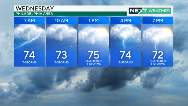
While the humidity levels will stay very muggy today, the other main difference will be the temperatures. Highs should stay in the mid-70s under cloudy skies, much different from the 100-plus heat indices we had Tuesday.
Thursday will be a similar day with increasing rain chances during the evening ahead of our second system, Tropical Storm Debby — or what's left of it — by week's end.
When will Tropical Storm Debby reach Philadelphia?
Models are coming to a better agreement that Debby will be picked up by another advancing trough and lifted into the northeast on Friday and Saturday.
Parts of our area will likely see widespread flooding rain as the moisture from Debby arrives with an additional 2-4 inches of rain possible. Damaging storms are possible as well during this time frame.
The biggest challenge will be to pinpoint where and when a majority of this will impact our area.
As of this morning, it looks like Debby has picked up speed and will now reach Pennsylvania, New Jersey and Delaware more quickly than previously thought - and be out of here earlier, as well.
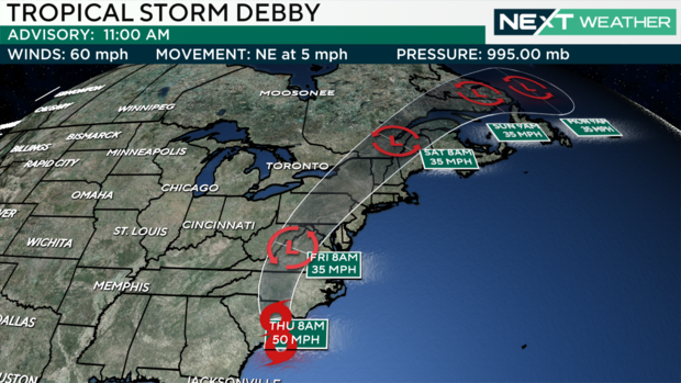
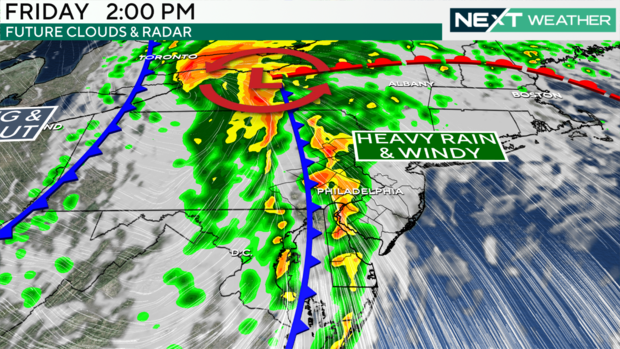
The heaviest rain from Debby looks to come for us around midday Friday, and then it's clearing out of here just in time for your weekend plans. If you had something outdoor planned for Saturday and were worried about Debby's impact, the outlook is improving, that's the best news to hear.
It looks like the bulk of rain from Debby will hit central and western Pennsylvania the hardest on Friday, the latest forecast models show.
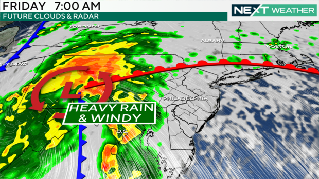
We still see some rain breaking off from the remnants into the late morning and afternoon on Friday.
As always, the NEXT Weather Team will keep you posted with constant updates throughout this busy week.
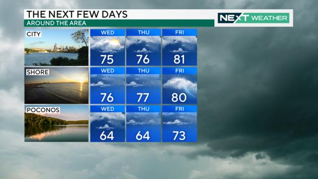
Here's your 7-day forecast
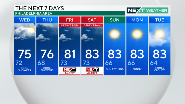
Wednesday: High of 75, low of 72, cool showers
Thursday: High of 76, low of 68, cool, showers
Friday: High of 81, low of 73, NEXT Weather Alert
Saturday: High of 83, low of 73. NEXT Weather Alert
Sunday: High of 83, low of 66, sun returns
Monday: High of 83, low of 66, sunny
Tuesday: High of 83, low of 64. partly cloudy
Get the latest weather info on the CBS News Philadelphia app