What causes fog? Philadelphia sees foggy and mild Monday to kick off wet week
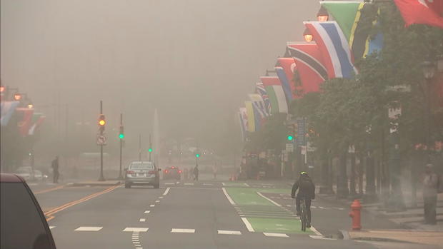
PHILADELPHIA (CBS) - The weekend is over and so are colder temperatures in Philadelphia, for now. But before the sun comes up, the fog is out, creating low visibility and potentially difficult traveling conditions for most of Monday morning.
The National Weather Service issued a Dense Fog Advisory until 10 a.m. Monday, covering southeastern Pennsylvania, most of interior New Jersey and New Castle and Salem counties in Delaware.
Under a Dense Fog Advisory, it's typical to see visibilities drop to one-quarter of a mile or less, which makes traveling in these conditions difficult. Drivers should take extra caution when driving.
In Philly and the immediate suburbs, visibility is around 0.3 miles. Mount Pocono is reporting visibility at zero.
The fog will likely begin clearing around around 9 or 10 a.m. Monday.
What causes fog?
According to the National Weather Service, there are several types of fog, but fog generally forms after cool air mixes with warm air. When this happens, the moist air cools and will reach a relative humidity of 100%, allowing fog to form.
Here's what Monday morning looked like on the Benjamin Franklin Parkway in Philadelphia.
What is the weather for today?
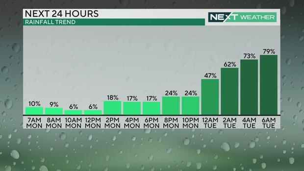
Temperatures will reach 75 degrees in Philadelphia on Monday with showers reaching the area overnight.
Around 2 a.m. Tuesday, a band of showers will move into the area and scattered showers will likely stick around until about noon. The sun will try to peak out late Tuesday afternoon.
Wednesday could be the driest day of the week. After morning showers, the rain should move out around 9 or 10 a.m. and temps will reach the mid-80s.
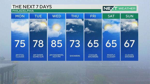
Here's your 7-day forecast:
Monday: Morning fog, clouds. 75
Tuesday: A.m. showers, some sun. 78
Wednesday: A.m. showers, hot p.m. 85
Thursday: Showers. 73
Friday: Cooler, showers. 65
Saturday: Mostly cloudy. 65
Sunday: Clouds, shower. 67
Get the latest weather info on the CBS News Philadelphia app.
