NEXT Weather: Week starts off with hot temps in Philadelphia region
PHILADELPHIA (CBS) -- After a weekend that brought a nice break from the heat and humidity, get ready for the 90s to return to the Philadelphia region as we head into the new week.
The same area of high pressure that moved in from the west to usher in relatively cooler and less humid air from Friday through Sunday has now shifted to the east. This has allowed the winds to shift to the southwest, which has already started to increase the warmth across the Northeast.
The high temperature in Philadelphia Sunday afternoon was 86 degrees, which is the normal temperature for Aug. 20. This was a few degrees warmer than the near 80-degree high temperatures around the region Saturday.
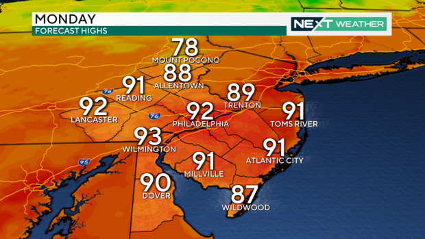
The dominance of high pressure has provided plenty of sunshine combined with relatively low humidity, but that will change Monday as the southwesterly flow will draw in a little moisture resulting in more scattered clouds and a hint of humidity. Despite the increased cloud cover, the southwesterly flow will send temperatures to the low 90s Monday afternoon across much of the Delaware Valley.
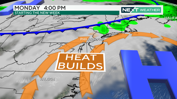
Even though highs in the low 90s in late August are a little warmer than normal, Monday's temperatures will still be a few degrees shy of the record. The record high on Monday in Philadelphia is 96 degrees set in 1916.
However, the return to the 90s will be short-lived, as a cold front will sweep through the region from the north Monday night. A few isolated showers will be possible ahead of the cold front overnight Monday into early Tuesday morning, but most will likely not receive any rain.
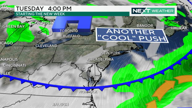
The cold front will move through with very little fanfare and begin to usher in cooler air throughout the day Tuesday.
Tuesday afternoon will be partly sunny with temperatures about 10 degrees cooler than Monday in the low 80s.
Temperatures look to remain a little cooler than normal with highs in the low 80s and lows in the low 60s with plenty of sun through the middle of the week before another series of storm systems brings some storm chances Friday and Saturday and then even cooler temperatures by next Sunday.
Here's your 7-day forecast:
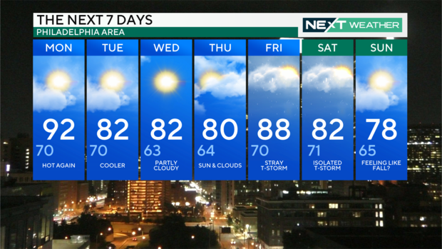
Monday: Hot again. High 92, Low 70
Tuesday: Cooler. High 82, Low 70
Wednesday: Partly cloudy. High 82, Low 63
Thursday: Sun & clouds. High 80, Low 64
Friday: Stray T-storm. High 88, Low 70
Saturday: Isolated T-storm. High 82, Low 71
Sunday: Feeling like fall?. High 78, Low 65
Get the latest weather info on the CBS News Philadelphia app.