Philadelphia weather: Heavy rain, flood risks Sunday into Monday


PHILADELPHIA (CBS) -- A powerful storm system and major cold front will push through the area Sunday and Monday, bringing with it heavy, flooding rain, gusty, possibly damaging winds, and coastal concerns from the Jersey Shore to Delaware.
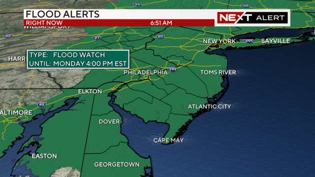
A NEXT Weather Alert Day is in effect through Monday afternoon, with everyone in the CBS News Philadelphia viewing area affected. A Flood Watch is in effect for the region from 1 p.m. Sunday through 4 p.m. Monday.
Rain will overspread the area early on Sunday. The first few drops of rain will fall across western areas—like Lancaster, Reading and the Lehigh Valley around 9 a.m., followed by everyone else in the late morning and early afternoon.
Behind the front on Monday, gusty winds will continue, ushering in colder and drier weather. The precipitation could end as a period of snow for the higher elevations Monday morning.
Let's talk timing
Rain will begin west of Philadelphia by late morning, with the city itself getting rain by noon. The Jersey Shore will see rain around this time as well, as a secondary area of low pressure along the front will develop and strengthen and spread rain very quickly across the area Sunday. Along with this, expect winds to be sustained between 15 and 25 mph, with gusts over 40 in the city and areas west. For this storm, the Jersey Shore will receive the brunt of the strongest winds, with some gusts approaching 50 mph by Sunday afternoon and Sunday night.
We could even have a few thunderstorms embedded within the rain, which could intensify the risk for wind damage. Greatest risk is over Delaware.
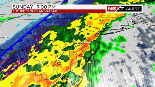
By 7 p.m., everyone in the Delaware Valley will experience heavy rain and at times, a driving wind. The likely height of the storm, with the strongest wind and heaviest rain, will be between 8 p.m. and midnight.
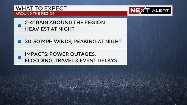
As the front approaches the shore late Sunday night, the wind and the rain will really pick up. Flooding along the shore is also a big concern at this time, with coastal erosion possible through Monday morning.
By 8 a.m Monday, the rain should taper off in most spots, although enough cold air may move into the Poconos to end this all as a brief period of snow. One-to-two inches are expected up in the highest elevations.
The entire area is under a Flood Watch through 4 p.m. Monday afternoon. Even though the rain will end hours earlier, oftentimes flooding on larger streams and rivers worsens in the hours following the heaviest rainfall, so we'll have to watch for lingering flooding concerns even into the Monday evening commute.
Gusty winds continue Monday afternoon, as the skies begin to clear toward the latter part of the day.
Staying safe during the storm
With 2 to 4 inches of rain expected across much of the area, it's important to stay off the roads and especially away from areas that are prone to flooding. We say it time and time again: If you're driving and see a road covered by water, DO NOT attempt to drive through. "Turn around, don't drown." Even a few inches of water can carry a car away.
While this is more of an areal flood threat than a flash flooding threat, heavy rain within any thunderstorm could pose the risk for flash flooding.
Winds around the city will gust to 35-40 mph - while this doesn't pose the risk for widespread outages, spotty outages are possible and especially likely at the shore where winds will gust to 50 mph. That said, now is a good time to have a plan of action in case you lose electricity. This is also the time of year for holiday decorations - make sure these are secured or brought indoors before the worst of the wind.
Make sure you have extra batteries, a flash light and phone chargers ready to go. Portable chargers that you power up before a storm are the best, as they can extend the life of your phone battery tenfold. Make sure you also have bottles of water handy, in case you do have to go without access to clean water for any extended period of time.
Finally: check on your elderly neighbors: especially if they live alone.
As this major storm system approaches, count on the CBS News Philadelphia Weather Team to keep you safe and ahead of the severe weather. And don't forget to download our FREE Weather App, so you can track it along with us!
READ MORE: Tie down those Christmas decorations! How Philly region is preparing for storm
Here's your 7-day forecast:
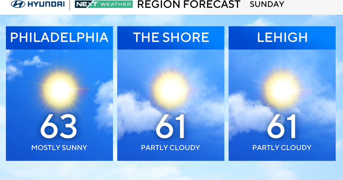
Sunday: High of 61, NEXT Weather Alert Day
Monday: High of 45, low of 40, NEXT Weather Alert Day
Tuesday: High of 45, low of 30, sunny and breezy
Wednesday: High of 43, low of 34, mostly sunny
Thursday: High of 39, low of 28, sunny and cold
Friday: High of 49, low of 28, mostly sunny
Saturday: High of 50, low of 33, seasonal and sunny