Philadelphia weather forecast comes with rain chances Tuesday, coastal flood advisory for New Jersey, Delaware

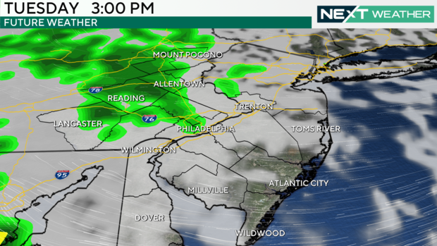
Tuesday will feature similar weather conditions to Monday in the Philadelphia region, along with pretty much every day this week, so you'll want to keep an umbrella handy in case of rain showers.
We'll have a chance for a few showers and a good mixture of clouds with only a few peeks of sun. High temperatures Tuesday will be in the low 70s once again.
There is a coastal flood advisory in effect at the Jersey Shore, where areas like Egg Harbor Township and Atlantic City saw climate-change-related nuisance flooding that closed Route 40 and other roads.
Delaware beaches are also included in this alert. There could be further issues before the advisory expires at 6 p.m. Tuesday.
The National Weather Service says affected areas Tuesday could include the back bays of Barnegat Bay in New Jersey, and the Little Assawoman Bay, Indian River Inlet and other back bays in Delaware.
Data from the National Water Prediction Service showed flooding is possible again Tuesday at New Jersey's Maurice River in Cumberland County, the Cape May Harbor and the Murderkill River in Delaware.
Wednesday is looking more active in terms of rain showers, which should be most widespread in the morning before tapering off. Those areas that do pick up a few showers could get a quarter to a half-inch of rain, but not much more than that.
Thursday morning, we could wake up to a few more showers, but conditions would clear out for the afternoon.
Tracking Tropical Storm Helene
Meanwhile, in the tropics, Tropical Storm Helene has formed in the northwestern Caribbean Sea. This system is forecast to become a hurricane as it tracks north into the Gulf of Mexico.
Record warm water in the Gulf could fuel the storm and help it strengthen. It is forecast to become a Category 2 and possibly a Major Category 3 hurricane before likely making landfall in the Big Bend region of Florida Thursday into Friday.
It is still a little early to say for certain but impacts from the storm on the Philadelphia area do not look likely aside from a few high clouds and a small chance of a stray shower later in the week into the weekend.
The NEXT Weather team will continue to monitor this storm as well as any other chance of rain through the week to help you plan for any potential impacts.
Here's your 7-day forecast:
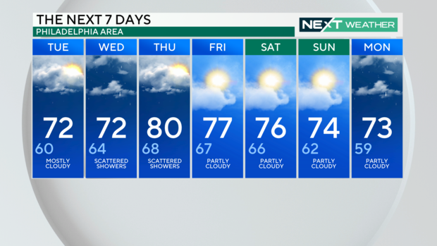
Tuesday: High of 72, low of 60, mostly cloudy
Wednesday: High of 72, low of 64, scattered showers
Thursday: High of 80, low of 68, scattered showers
Friday: High of 77, low of 67, partly cloudy
Saturday: High of 76, low of 66, partly cloudy
Sunday: High of 74, low of 62, partly cloudy
Monday: High of 73, low of 59, partly cloudy