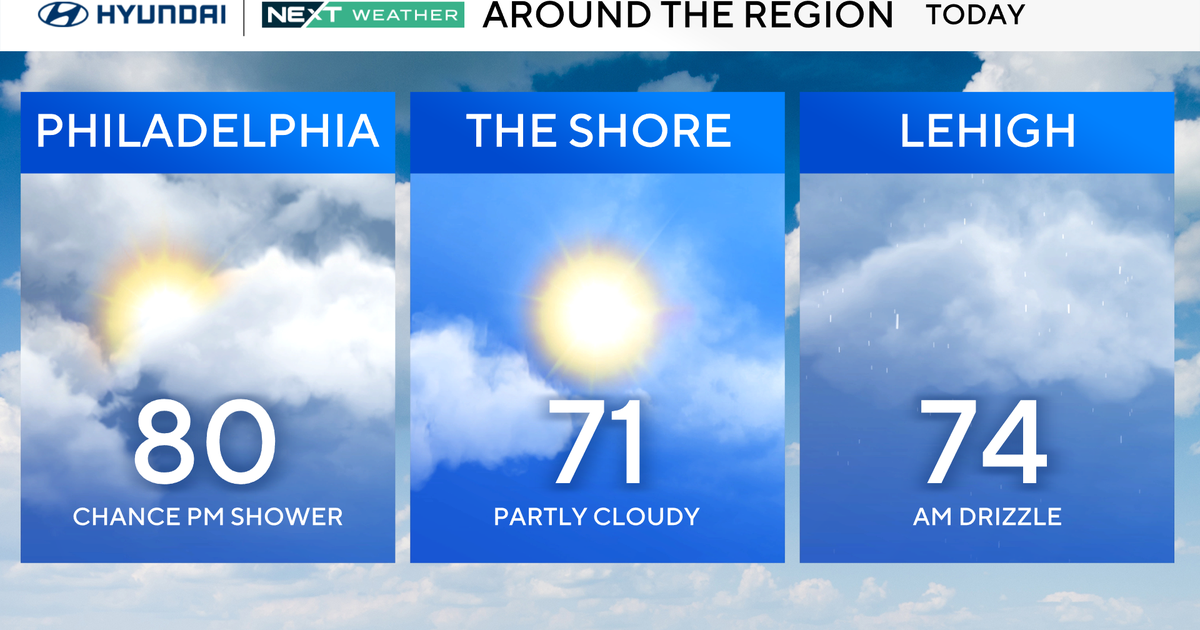
Philadelphia weather: Significant winter storm system possibly coming to town this weekend


UPDATE: Philadelphia weather: Weekend storm to bring rain, snow and coastal erosion
PHILADELPHIA (CBS) -- Just as the calendar turns over to January, our NEXT Weather team is tracking the first decent chance of a significant winter storm that the Philadelphia area has had in two years.
What a pitiful winter for snow last winter was with a measly 0.3 inches of snow recorded in Philadelphia, the last real measurable snowfall hasn't happened since Jan. 29, 2022, when 5.8 inches of snow fell. This was over 700 days ago which puts Philly in an active streak for the longest stretch without an inch or more of snow.
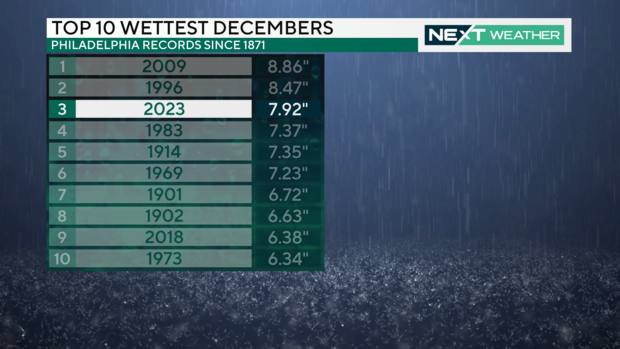
Several storm systems throughout December were primarily rain and flooding events that landed December 2023 in the third position for the rainiest December on record for the Philadelphia area. The active pattern we saw in December looks to continue right into the new year, and now there will be some cold air to work in.
Setting the stage
Before the main event on Sunday, a fast-moving and relatively low-impact system will sweep through the region on Thursday. This event will have two separate weather features, a coastal low to the southeast and a cold front to the west, that will combine to bring a chance for some snow and rain to the region on Thursday. Our meteorologists forecast little to no snow accumulation most likely across the Lehigh Valley and Poconos.
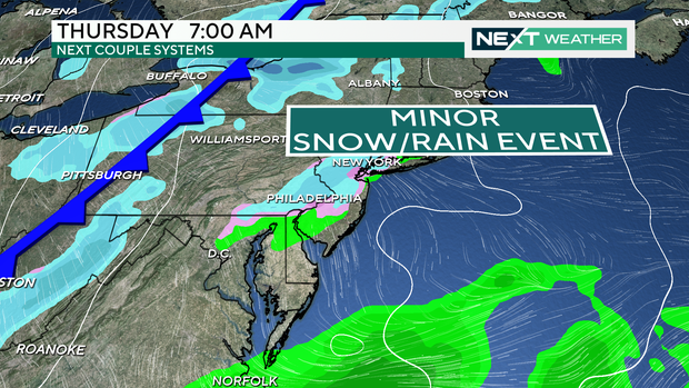
The cold front that will sweep through the area Thursday will usher in an area of high pressure out of Canada that will send colder temperatures into the Northeast on Friday and Saturday. The strength of this high-pressure system, combined with the degree of the cold air, will play a part in how the storm system developing out of the Southeast unfolds as it tracks into the Northeast.
How it looks now
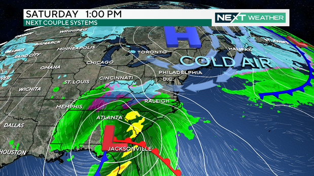
Being that the storm system is still five to six days away, there is still a lot of time for the different elements to take shape. As we sit on the first day of the year, it appears likely that a storm system will track out of the Southeast and strengthen as it moves through the Mid-Atlantic into the Northeast.
Heavy rainfall and gusty winds look likely in the storm's path with areas on the north and western side of this storm in store for some snow. At this point, given the recent storm systems that have brought the area several inches of rain, saturated soil and swollen waterways are already subject to more flooding with even a relatively small amount of rain.
As with all of these storm systems, the exact track of the low-pressure system will greatly determine the nature of all of these details and ultimately which areas see what impacts. That said, as of Monday it appears that this storm system does have the potential to bring the best chance of notable snowfall to the Philadelphia area since Jan. 29, 2022.
Forecast details
There will always be a certain level of uncertainty in a potential storm system that is five to seven days out. In this time frame, meteorologists track trends of the storm system in the various forecast models. Several trends and questions need to be monitored. Is the system even still going to develop? Is it more or less likely? Is it tracking more to the north or the south? What are the overall trends and consistency in the forecast models?
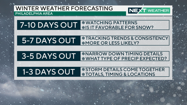
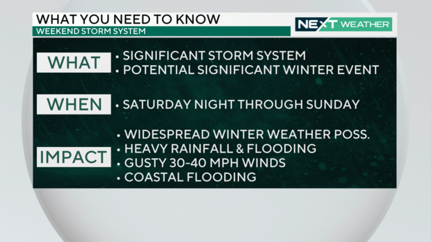
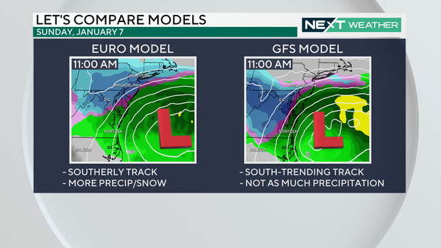
This phase is where we are right now. The models continue to show a potentially significant storm system moving into the region Saturday night into Sunday. There has also been a trend in the recent forecast models that track the center of the storm more to the south. This scenario would allow for more of the precipitation across the area to fall as snow, but if the storm tracks far enough south then we could miss out on the majority of the precipitation altogether.
The margin for change remains fairly large five to seven days out which is why forecasters tend to paint the forecast picture with a fairly broad brush, highlighting several different potential outcomes.
Once the event is within three to five days there is typically an increased level of confidence in how the storm system is going to evolve, and the details of precipitation type and timing usually begin to unfold. Regarding this weekend's storm system, these details would likely become a little more clear on Wednesday and Thursday.
By Friday, regardless of how this storm system looks to develop, there should be an increasing understanding of how the storm system is going to come together. In other words, this is when we would likely start discussing snow totals, locations for those totals and timing. Of course, this is all assuming the storm plays out.
Wrapping it up
We all want to know all of the details of a potentially impactful weather event as soon as possible, but at this time too much can and will change to lay out those specifics.
The bottom line is that the NEXT Weather Team is tracking a storm system that is expected to move into the region Saturday night and through the day on Sunday and has the potential to have significant impacts to the region. There is also the potential that those impacts could come in the form of winter weather, but that is yet to be fully determined. Each day will bring a clearer picture of the forecast and our NEXT Weather Team will be sure to keep you updated and informed with the latest details.