Sunny, breezy Wednesday in Philadelphia region as drought conditions continue. Here's the full forecast.
It was a record-breaking warm day on Tuesday — Philly hit 84 degrees, breaking the old record high temperature of 83 degrees set on Oct. 22, 1920.
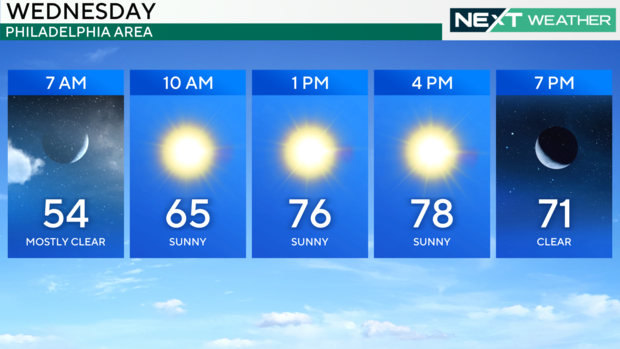
Now, Wednesday morning is off to a cool start in the 50s. After that, a warm afternoon and evening are in store with a high near 80. The high is short of the record of 87 degrees set in 1947, but still about 15-20 degrees warmer than usual for this time of year.
Skies should be clear and sunny for most of us at first, with a few more clouds along the Jersey Shore thanks to a system passing by offshore.
In the afternoon you'll notice cloud cover and a gusty breeze pick up ahead of an advancing cold front.
A change in temps will occur on Thursday as that cold front passes through and knocks the temperatures back to the low and mid-60s through Saturday. That's nearly a 20-degree drop from Wednesday's high in the low 80s.
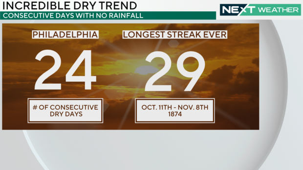
The cold front will be dry, however, offering no end to the rainless streak of 24 days (so far). A gusty northwest breeze behind the front will also contribute to enhanced fire danger as winds can cause flames to spread rapidly.
There is another weak front that will cross the area on Saturday, which will bring even cooler air for Sunday. If that front produces measurable rain at Philadelphia International Airport, our dry streak will end. Otherwise, next Sunday we will tie the longest dry streak in Philadelphia history, and on Monday, Oct. 28, we'd break that record. The current streak is 29 days, which was set 150 years ago in the fall of 1874. The odds are good that it will be broken.
It's not just Philadelphia, many cities up and down the eastern seaboard have gone weeks without rain. The drought is impacting a good portion of the Midwest and mid-Atlantic.
The increasingly dry conditions have created a moderate drought for most of southeastern Pennsylvania, Delaware and South Jersey. There is also an expanding area of severe drought in central South Jersey and conditions are likely to move to the next level of an extreme drought soon.
A drought watch has been issued for all of New Jersey. The last drought watch for the Garden State area was in 2022 and the last drought warning was in 2002.
We have had no rain this month, and since Sept. 1 we have only had 0.77 of an inch of rain, leaving us a whopping 6.16 inches below average for the fall season. These dry conditions coupled with unseasonably warm temperatures and low humidity have also created a very high fire danger across the area. Residents are urged to limit the use of any outdoor flames.
In the Tropics, Oscar is now a post-tropical low and fading out as just an area of low pressure. No other named storms or areas of interest are on the map at this time.
Here's your 7-day forecast:
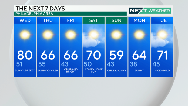
Wednesday: Sunny, breezy. High 80, Low 52.
Thursday: Sunny, cooler. High 65, Low 56.
Friday: Crisp and bright. High 66, Low 43.
Saturday: Comfy, some sun. High 70, Low 50.
Sunday: Chilly, sunny. High 59, Low 43.
Monday: Sunny. High 64, Low 38.
Tuesday: Nice and mild. High 71, Low 45.