Scattered showers, heavy downpours, rip currents and high surf in Philadelphia weather forecast
PHILADELPHIA (CBS) — The Philadelphia region will see rainy weather both days of this weekend. Ditch the sunglasses and keep the umbrella handy on Saturday and Sunday as a slow-moving storm system will approach from the west with clouds, showers and storms.
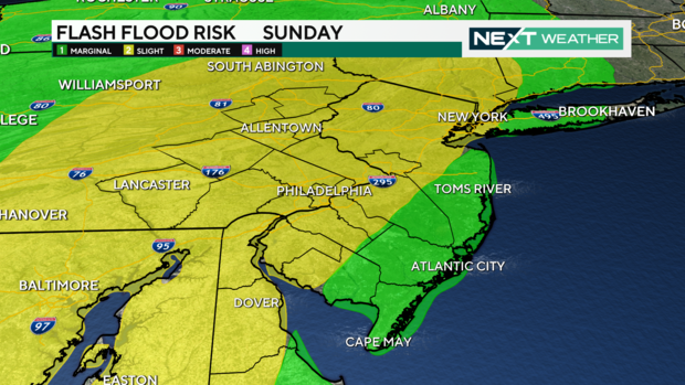
Any storms on Saturday should remain below severe limits but on Sunday a NEXT Weather Alert has been issued for the threat of severe storms.
We are currently in a Marginal Severe Risk (level 1 of 5). Heavy rain with flash flooding and damaging wind gusts are the threats.
Trying to avoid the rain and re-arrange any outdoor plans? Here is the timing for the weekend rain so you can be prepared and protected.
- SATURDAY: Scattered showers and isolated storms. Any storm could produce very heavy rain and localized flash-flooding.
- SATURDAY NIGHT: Isolated showers and storms will continue overnight.
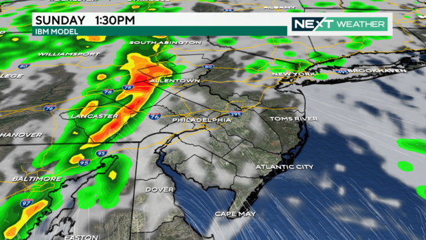
- SUNDAY: Spotty showers possible in the morning but by early afternoon a line of slow moving, strong to severe storms will arrive moving west to east.
Coastal Flood Advisory along Delaware River Saturday night
There is a Coastal Flood Advisory in effect for Saturday night's high tide for areas along the Delaware River. Data from the National Water Prediction Service shows the Delaware River and Bay could crest above the minor flood stage around high tide - which rolls north up the river. High tide is around 8 p.m. at the bay in Lewes, Delaware, but around midnight in Philadelphia.
Remember to use caution if driving during heavy rain. Do not risk driving through flooded roads, as it only takes a few inches of water to stall your vehicle, and a few inches more could float the entire thing. Remember, "turn around and don't drown."
When do storms arrive on Sunday in Pa., NJ and Del.?
In preparation for Sunday's severe weather, the National Weather Service issued a flood watch for parts of Delaware, New Jersey and Pennsylvania effective from 2 a.m. Sunday through late Sunday night.
The following counties are included under the flood watch:
Delaware: New Castle
New Jersey: Camden, Gloucester, Mercer, northwestern Burlington, Salem
Pennsylvania: Berks, Delaware, eastern Chester, eastern Montgomery, Lehigh, lower Bucks, Northampton, Philadelphia, upper Bucks, western Chester and western Montgomery
There doesn't look to be a major storm threat Sunday morning. We start to see a line of storms push through in the afternoon from west to east.
- 1 PM - 4 PM: The storms are in Lehigh Valley, Berks, Chester County, upper Montgomery and Bucks counties.
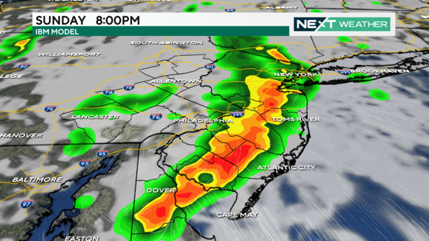
- 3 PM - 7 PM: Lower Montgomery, lower Bucks, Delaware, New Castle and Philadelphia counties plus areas adjacent to I-95 in South Jersey.
- 4 PM - 8 PM: South Jersey, Central and southern Delaware and the Shore.
The storms may linger along the Shore until midnight.
These parts of the region are under an excessive rainfall risk on both Saturday and Sunday:
- Chester County
- New Castle County
- Berks County
- Lehigh County
- Upper Montgomery County
- western Delaware County
Monday will be our weather transition day. Scattered showers are possible with highs in the low 80s.
By Tuesday a touch of fall arrives with sunshine and highs in the low to mid-70s with overnight lows in the 50s.
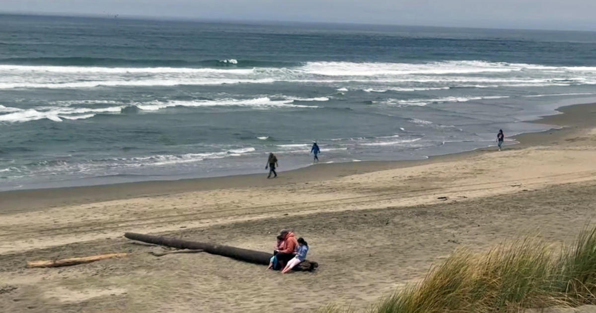
Rip current risk at Jersey Shore, Delaware beaches from Hurricane Ernesto
Hurricane Ernesto might be hundreds of miles away in the Atlantic Ocean, but we're still seeing its effects at the Jersey Shore and the Delaware beaches.
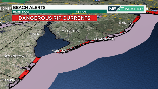
The sea is angry this weekend as the massive Ernesto makes landfall in Bermuda Saturday morning. Beach conditions will be dangerous along all of the Jersey Shore and Delaware Beaches through early Monday.
The rip current risk is very high with high surf and nearshore waves reaching 5 feet to 10 feet high. Best to avoid swimming at the Shore.
In Ventnor, the beach patrol captain told CBS News Philadelphia's Madeleine Wright that swimming will likely be restricted to waist-deep water, if it's allowed at all.
Remember to only swim on guarded beaches and follow lifeguards' orders. If you get caught in a rip current, swim parallel to the shore until you get out and don't panic. Swimming against a rip current is likely not possible.
We have a guide on how to spot a rip current and how to stay safe during this dangerous beach condition.
Weather forecast includes potential rain on Phillies' alumni weekend
The Phillies are having a big weekend with alumni like Mike Schmidt, Carlos Ruiz, Brad Lidge, Ryan Howard and many more in town.
There could be some passing showers Saturday but nothing that would cancel Saturday night's 6:05 p.m. game against the Washington Nationals.
Of bigger concern is the 1:35 p.m. game Sunday at Citizens Bank Park. The latest models show the early innings of the game would likely be dry, but there could be some rain in the mid- to late innings.
You will definitely want to keep a close eye on the weather forecast and on the Phillies' official channels if you are heading to Sunday's game.
Stick with the NEXT Weather team for more.
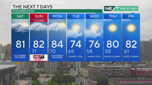
Here's your 7-day forecast:
Saturday: Scattered showers. High 81
Sunday: NEXT Weather Alert for scattered T-storms and downpours. High 82, Low 71
Monday: Scattered showers. High 84, Low 70
Tuesday: Sunny and cool. High 74, Low 65
Wednesday: More fall-like feeling. High 76, Low 58
Thursday: Mostly sunny. High 80, Low 58
Friday: Mostly sunny. High 82, Low 61

