Cool weather returns to Philadelphia region this week; Hurricane Milton now a Category 5 storm
Skies start cloudy Monday but will clear out later in the morning and give way to a sunny afternoon as cooler air begins to rush into the area from the northwest. It'll feel breezy with winds likely blowing between 10-20 mph.
After that, we'll welcome in a brisk and cool pattern throughout the week with highs only in the upper 60s and low 70s and morning lows in the 40s.
Speaking of the 40s, the average first occurrence of lows in the 40s in Philly is Sept. 30. We are behind schedule but nowhere near the record latest first occurrence, which is Oct. 20.
The overnight lows this week will be the coolest we've seen so far this season.
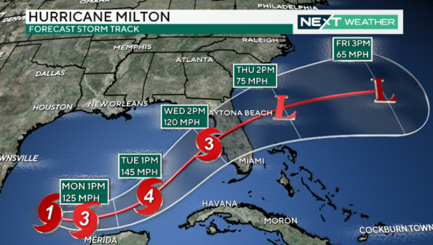
Hurricane Milton now a Category 5 storm
In the tropics, Hurricane Milton was upgraded to a major Category 5 storm Monday afternoon.
With its northeast trajectory, the west coast of Florida needs to brace for another major hurricane, with winds that could likely gust over 160 mph, with widespread rainfall of 5 to 8 inches, in addition to storm surge flooding. Areas from the panhandle to Tampa to even the Keys need to be on high alert as we monitor this serious threat.
As always, the NEXT Weather Team will keep you and your family ahead of the storm and alert you to any potential impacts.
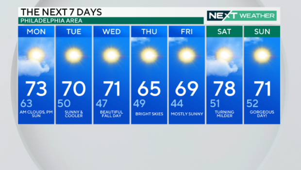
Here's your 7-day forecast:
Monday: AM clouds, PM sun. High 73, Low 63.
Tuesday: Sunny and cooler. High 70, Low 50.
Wednesday: Beautiful fall day. High 71, Low 47.
Thursday: Bright skies. High 65, Low 49.
Friday: Mostly sunny. High 69, Low 44.
Saturday: Turning milder. High 78, Low of 51.
Sunday: Gorgeous day! High 71, Low of 52.
