Philadelphia weather forecast for rain, storms, flood risks, lightning; when they arrive in Pa., NJ, Del.
PHILADELPHIA (CBS) -- Flood watches and severe thunderstorm warnings are in effect across the Philadelphia region on Saturday as storms move through the area that could bring heavy rain, lightning strikes and potentially damaging winds.
Philadelphia International Airport warned travelers flying in and out of Philadelphia that their flights could be delayed due to inclement weather conditions.
The National Weather Service issued the flood watches for parts of Pennsylvania, New Jersey and Delaware just after noon and said they expire at midnight. NWS says to monitor forecasts and be prepared in case flash flood warnings are issued.
Storms before midnight could bring heavy rain, and some parts of the region may get multiple rounds of storms.
The NWS issued a severe thunderstorm warning for the following New Jersey counties until 10 p.m.: Atlantic, Ocean, Camden, Gloucester and Burlington
The NWS previously issued a severe thunderstorm watch for several counties throughout the Delaware Valley that expired at 9 p.m.
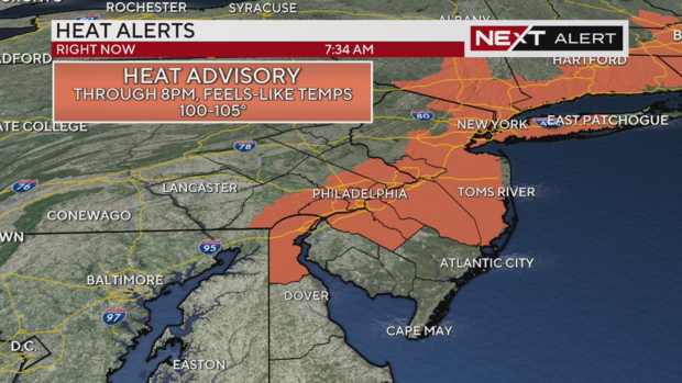
Hot and humid weather persists today around the Philadelphia area, with high temperatures in the low 90s and a heat index (feels-like) temperature of 100-105 degrees.
That heat index has once again triggered a heat advisory for parts of the area included along the I-95 corridor. Those areas included are lower Bucks County, lower Montgomery County, Philadelphia, Delaware and lower Chester counties in Pennsylvania along with New Castle County in Delaware and Gloucester, Camden, upper Burlington and Mercer counties in New Jersey.
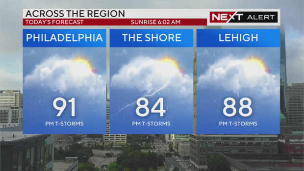
While the high temperature is only 91 today in Philadelphia, the high humidity will still make it feel like the triple digits in the afternoon. Expect slightly cooler temperatures up in the Lehigh Valley and down at the Jersey Shore, still with lots of humidity.
This heat and humidity sets up plenty of energy in the atmosphere for storms to fire up on Saturday afternoon and evening.
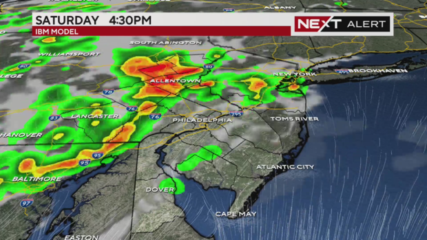
An area of low pressure with a trailing cold front will approach from the Ohio Valley. The system will trigger showers and storms that will cross the area from west to east this afternoon and evening.
Throughout the day today we will remain in the warm and soupy sector of this storm system. Any sunshine will destabilize the atmosphere creating the perfect set up for severe storms.
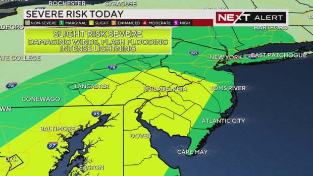
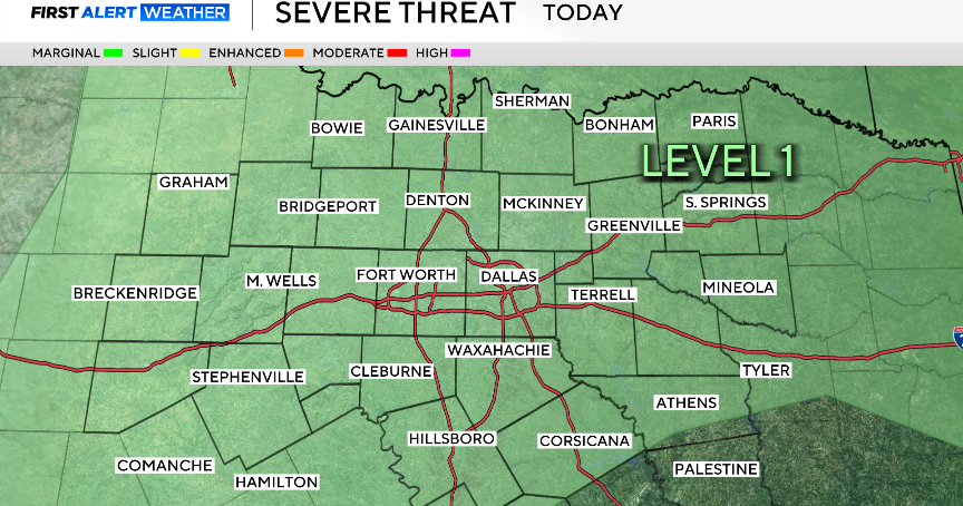
A large swath of our region is under a Level 2 or "slight" risk for severe weather on Saturday associated with these storms, including Philadelphia, Delaware County, Chester County, Montgomery County, Bucks County and parts of Berks and Lancaster counties in Pennsylvania.
Camden, Cumberland, Gloucester and Salem counties are also included in this risk zone along with parts of Burlington and Atlantic counties in New Jersey. And in Delaware, New Castle and Kent counties, as well as parts of Sussex County, are in the level 2 risk zone. The rest of the region is under a lesser Level 1 or "marginal" risk of severe weather.
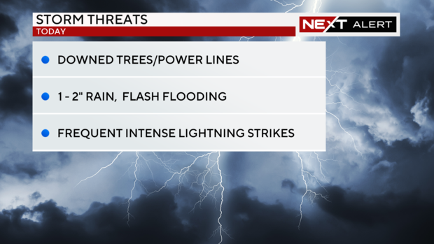
The main threats from these storms will be damaging winds that can topple trees and down power lines. There will also be torrential downpours with any storm, and a quick one to two inches of rain will be possible which could lead to localized flash flooding.
Driving will be difficult in the rain as it will come down so hard your visibility will be greatly reduced. Finally, there will be very intense and frequent lightning.
When do storms arrive? Timing out who sees rain first in Pa., NJ and Del.
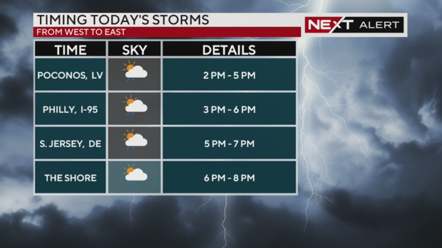
Here are the timings for the main severe weather threat today in Pennsylvania, New Jersey and Delaware.
- Poconos and Lehigh Valley: 2 p.m. to 5 p.m.
- Philadelphia and all areas on either side of I-95 including northern Delaware: 3 p.m. to 6 p.m.
- Inland South Jersey and far southern Delaware: 5 p.m. to 7 p.m.
- The Jersey Shore: 6 p.m. to 8 p.m.
Lightning risks with stormy weather hitting Pa., NJ and Del. today. Stay inside.
Any storms hitting on Saturday have the potential for frequent lightning.
Please make a plan for you and your family to be indoors during any storm and don't forget the pets. This will be especially important for any youth sports or other outdoor events later today.
What's next in the Philadelphia weather forecast after Saturday storms?
Scattered showers and isolated storms will continue through midnight.
We start Sunday with clouds giving way to sunshine and another round of afternoon/evening storms. It will not be as hot, but the humidity will persist.
The storm system that triggers today's storms will not clear our area until Sunday night.
Monday will be the driest day with sun and highs back in the 90s. The remainder of next week will be unsettled with a chance of showers and storms each day and much cooler temperatures in the upper 70s to mid-80s.
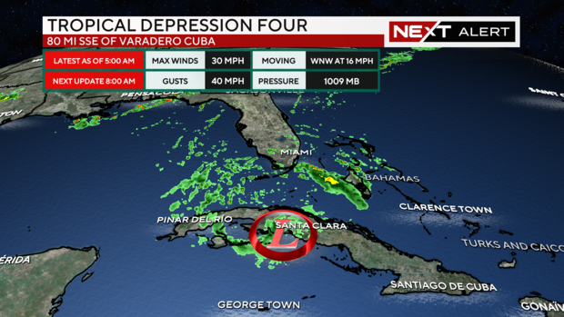
Tropical Depression 4
Elsewhere all eyes are on the Gulf of Mexico where Tropical Storm Debby formed today. Tropical storm warnings and hurricane watches are in effect for Florida's west coast with winds of 39-70 mph expected. Also, a storm surge of two to five feet leading to widespread flooding and rainfall of four to eight inches.
The storm will move over the extremely warm Gulf waters and intensify as it moves north from Cuba toward the Big Bend region of Florida. The track may continue to shift and all areas of Florida are preparing for the storm.
By Monday, the storm is expected to exit over the Atlantic where it will slowly move up the east coast creating flooding concerns.
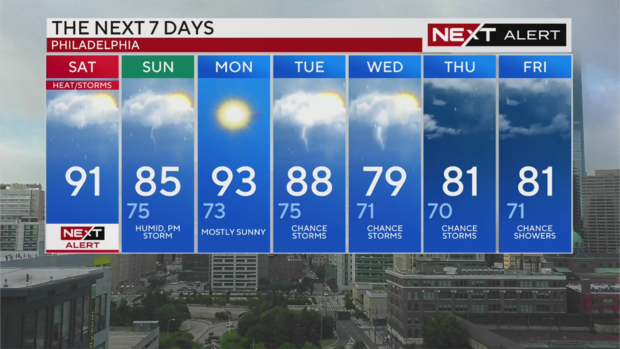
Here's your 7-day forecast:
Saturday: NEXT Weather Alert for heat and storms. High 91, feels like 100.
Sunday: Humid with PM storm chances. High 85, Low 75
Monday: Mostly sunny, less humid. High 93, Low 73
Tuesday: Chance of storms. High 88, Low 75
Wednesday: More storm chances. High 79, Low 71
Thursday: Chance of storms. High 81, Low 70
Friday: Chance of showers. High 81, Low 70

