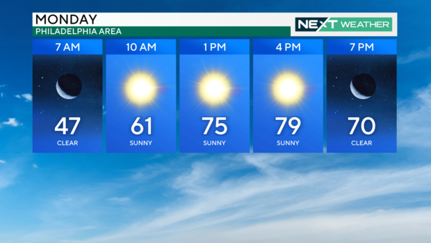
Sunny, dry weather continues Monday in Philadelphia along with drought concerns. See the full forecast.

Our streak of dry, sunny and warm days will continue the next few days with temperatures climbing into the 80s Monday through Wednesday in the Philadelphia region.
On Tuesday, we will be chasing the record high temperature of 83, which was set 104 years ago in 1920. Get out and enjoy what may be the last gasp of true warmth because a weak cold front passes the region early Thursday, knocking down the temperatures back to the low and mid-60s. That's nearly a 20-degree drop from Wednesday's high in the low 80s.
We desperately need rain, unfortunately, Wednesday's cold front brings nothing more than clouds as it passes overhead, leaving us in a race for the longest dry streak in Philadelphia history. The current streak is 29 days, which was set 150 years ago in the fall of 1874. The odds are good that we will break that record.
The increasingly dry conditions have created a moderate drought for most of southeastern Pennsylvania, Delaware and South Jersey. There is also an expanding area of severe drought in central South Jersey and conditions are likely to move to the next level of extreme drought in the near future.
A drought watch has been issued for all of New Jersey. The last drought watch for the Garden State area was in 2022, and the last drought warning was in 2002.
This month, we have seen no rain, and since Sept. 1, we have only had about three-quarters of an inch of rain, leaving us nearly 6 inches BELOW average for the fall season.
It has been 22 days since measurable rain has fallen on the Delaware Valley. If we continue this rainless streak until Oct. 28, we will set a new record for the longest dry stretch in Philadelphia history.
These dry conditions coupled with unseasonably warm temperatures and low humidity have also created an elevated fire danger across the area. Residents are urged to limit the use of any outdoor flames.
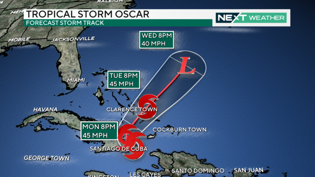
In the Tropics, things have gotten busy once again.
Hurricane Oscar made landfall on Sunday evening along the southeast coast of Cuba near Guantanamo Bay as a Category 1 storm but has now been downgraded to a tropical storm. Over the next few days, the storm will curve to the northeast and head into the Atlantic toward Turks and Caicos and Bahamas. At this point, it is not expected to affect the United States.
Here's your 7-day forecast:
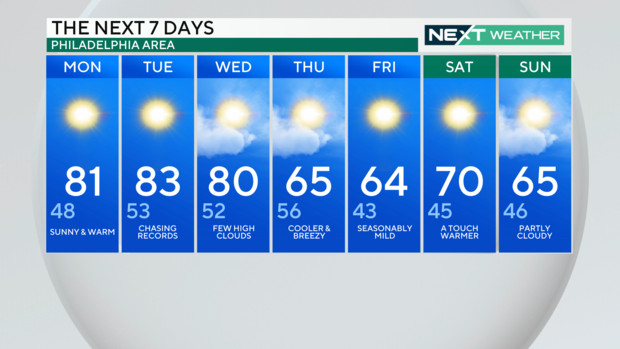
Monday: Sunny and warm. High 81, Low 48.
Tuesday: Chasing records. High 83, Low 53.
Wednesday: Few high clouds. High 80, Low 52.
Thursday: Cooler and breezy. High 65, Low 56.
Friday: Seasonably mild. High 64, Low 43.
Saturday: A touch warmer. High 70, Low 45.
Sunday: Partly cloudy. High 65, Low 46.