Heat wave enters 6th day in Philadelphia, excessive heat warning in effect through Wednesday

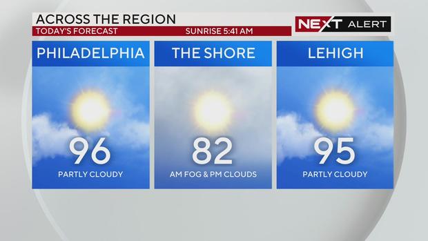
PHILADELPHIA (CBS) — The hot and uncomfortably muggy weather conditions continue today around the Philadelphia area. An excessive heat warning is in effect for parts of the region until 8 p.m. Wednesday.
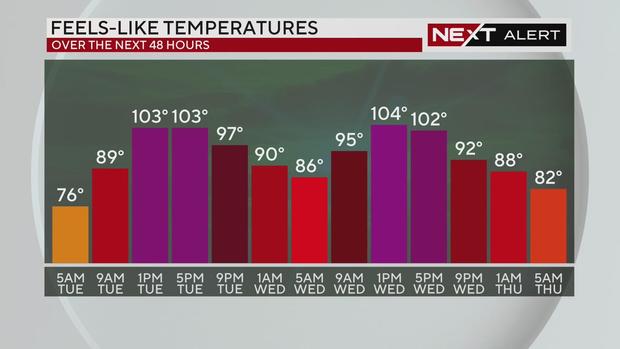
Because of the dangerous heat, both Tuesday and Wednesday are NEXT Weather Alert Days. Tuesday marks the sixth day of the ongoing heat wave with highs expected to hover in the mid-90s. However, the heat index (aka feels-like temperature) will make it feel like up to 105 degrees.
Because of the cumulative effect of warm nights and hot days, it is important to stay hydrated and stay cool. Dozens of pools have opened for the season around Philadelphia, along with cooling centers. But if you do spend any time outside, be sure to know the signs and symptoms of heat stroke and heat exhaustion.
Health experts also suggest wearing light-colored loose-fitting clothing and a hat to keep the sun off your face. Taking regular and frequent breaks in the air conditioning can also help.
If you want to cool down inside, a cool or lukewarm shower or bath could do wonders — with some research showing lukewarm water will actually cool you down faster, as your body won't shiver.
You could try throwing some grapes or other fruit in the freezer overnight and taking it with you as a cooling snack for your day.
And don't forget the pets: They need shade or an indoor space with cool water.
Code Orange remains in effect for Philadelphia-area counties
A Code Orange air quality alert issued in several counties in the Philadelphia area will continue Tuesday.
According to the Pennsylvania Department of Environmental Protection (DEP), Philadelphia, Bucks, Montgomery, Delaware and Chester counties are all included in the Air Quality Action Day due to ozone pollution. This happens frequently with a prolonged heat wave as pollutants become trapped near the Earth's surface.
Air quality in the "orange" category is considered unhealthy for sensitive groups, including children, the elderly and those with lung conditions like asthma, according to the EPA's Air Quality Index. People included in those sensitive groups are urged to limit the amount of time they spend outside while air quality is poor.
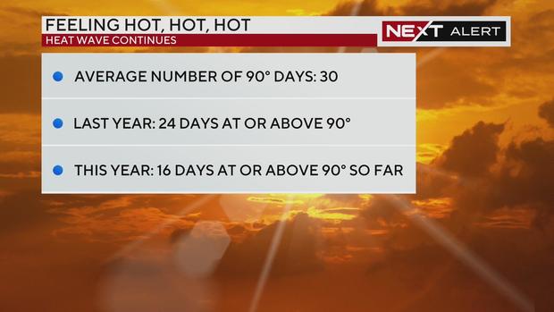
Philadelphia on track to have more 90-degree days than in 2023
Philadelphia averages 30 90-degree days each year, and we have already seen 16 90-degree days in 2024. Last year, the city recorded 24 90-degree days, so with most of the hot season still ahead of us, Philadelphia's on track to beat 2023's numbers.
This is also our eighth consecutive month of above-average temperatures.
And with even more 90-degree days in the forecast, the heat wave could last for an entire week.
Next chance for rain
Isolated thunderstorms are possible the next few days with brief downpours providing relief from the heat. However, most of the area will remain dry, and any storms that develop are not expected to reach severe limits.
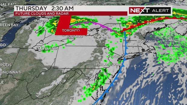
Relief from the heat may be headed our way by Wednesday night as the remnants of Hurricane Beryl cross our region. A cold front will settle across the Delaware Valley late Wednesday and hover near the coast on Thursday. We could benefit from slightly lower humidity inland, but on Friday the cold front looks to likely stall over the region and act as the focal point for scattered but locally heavy showers and storms throughout the day.
Showers and thunderstorms will linger at least through the first part of Saturday before we dry out later in the day and Sunday.
So while the incoming cold front will bring an end to this extreme heat, highs will still stay in the low 80s and jump back into the 90s over the weekend.
There will also be more fog down the shore each day this week. As the warm, moist air moves over the colder ocean water fog forms with visibilities dropping below ¼ of a mile at times.
Stay with the NEXT Weather Alert team for the latest updates on the heat, the remnants of Beryl and any storms.
Here's your 7-day forecast:
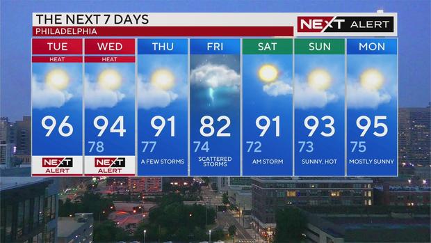
Tuesday: High of 96, NEXT Weather Alert Day
Wednesday: High of 94, low of 78, NEXT Weather Alert Day
Thursday: High of 91, low of 77, a few storms
Friday: High of 82, low of 74, scattered storms
Saturday: High of 91, low of 72, AM storm
Sunday: High of 93, low of 73, sunny and hot
Monday: High of 95, low of 75, mostly sunny