Most intense heat wave for Philadelphia area in years: What to expect this week

PHILADELPHIA (CBS) -- The well-advertised heat wave is about to get started, and it will last through the week and potentially through next weekend as well.
As a ridge of high pressure builds over the eastern United States temperatures soar and then get even hotter going into the weekend.
Going into the second half of June, the normal high temperature in the Philadelphia area is in the middle 80s. During the summer months, a heat wave is generally considered to occur when temperatures are forecast to be warmer than 90 degrees for more than two days in the row.
Not only are temperatures forecast to be warmer than 90 degrees more than two days in a row, they will reach into the middle and upper 90s and might even get close to 100 degrees by next weekend.
The stretch of hot temperatures has prompted the CBS Philadelphia NEXT Weather Team to issue a NEXT Weather Alert from Tuesday through Sunday.
High temperatures Monday afternoon will peak around 90 degrees, which the Philadelphia International Airport has already had as a high temperature three times earlier this year, including just this past Friday. As the dome of high pressure strengthens, it will send temperatures Tuesday afternoon into the middle 90s with heat indices approaching 100 degrees.
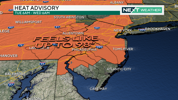
For this reason, the National Weather Service has issued a heat advisory for most of the area from 6 a.m. Tuesday until 6 a.m. Wednesday.
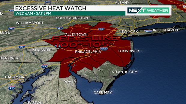
The heat and humidity are expected to not only persist into the middle of the week but could increase. By Wednesday, high temperatures around the region will be in the middle 90s, and the heat index could exceed 105 degrees. Temperatures could then increase even more through Friday and Saturday.
Conditions this hot for several days in a row could certainly become dangerous if cooling precautions are not taken. For this reason, an excessive heat watch has been issued from 6 a.m. Wednesday until 8 p.m. Saturday.
A heat advisory and an excessive heat warning means that people can be affected by heat if precautions are not taken. The issuance of a heat advisory is important to raise public awareness that these precautions need to be taken. Heat advisories are also used to trigger other actions and regulations such as no evictions, no turning off of power, changing outdoor work requirements, etc.
An excessive heat Warning will alert hospitals and officials to take certain actions to prepare and respond to an increase in emergency calls, and activate programs to check on elderly and home-bound people. In some cases, cooling centers can be open or designated and donation programs activated for fans and air conditioners. As in the case of an advisory, certain regulations may change, such as turning off people's electricity, evictions and outside work requirements.
You can find the nearest cooling center, public pool or sprayground in Philadelphia here.
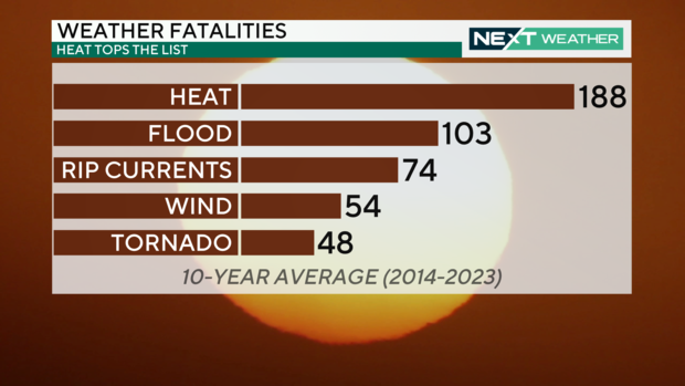
According to the National Weather Service, studies in Canada, Europe and the U.S. indicate mortality begins to increase exponentially as the heat increases or stays above a heat index of 104 degrees. In fact, heat is the top weather killer in the United States. The 10-year average (2014-2023) of heat-related deaths is 188, with flood-related deaths coming in second at 103.
While the heat and the duration of the heat wave will be formidable, the high temperatures are not guaranteed to break any daily records, but a couple days will be close.
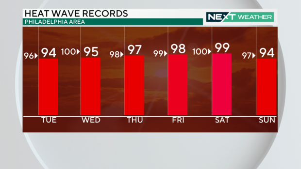
Currently, the forecast high on Tuesday is 94 degrees and the record high for that day is 96 degrees. Another day that will be close to a record high is Friday, with a forecast high of 98 degrees and a record of 99 degrees. Saturday's forecast high of 99 degrees will also be within one degree of its daily record high of 100 degrees.
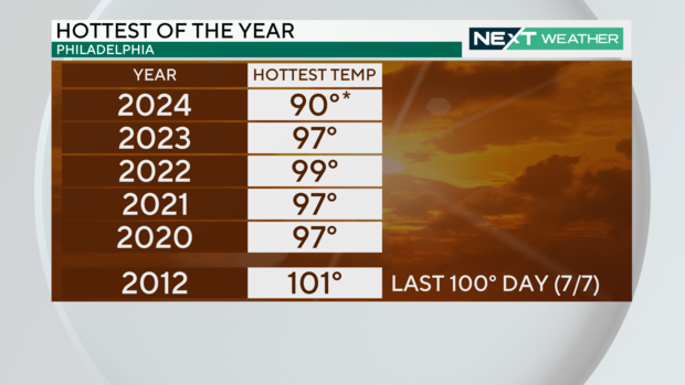
Speaking of 100 degrees, the last time the Philadelphia area recorded a high temperature of 100 degrees or warmer was on July 7, 2012, when it was 101 degrees. Right now, the NEXT Weather Team is not forecasting a high temperature during this heat wave to reach 100 degrees, but if the temperature does climb into the triple digits, it will be the hottest in more than a decade.
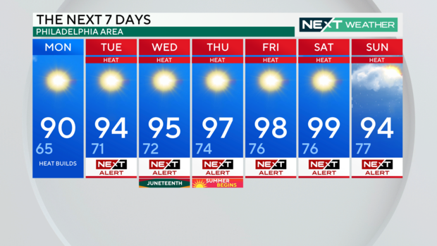
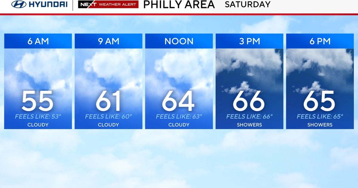
At this point, temperatures are forecast to remain in the low-middle 90s through Sunday before a cold front looks to bring a chance for some showers and storms that will usher in some relatively cooler air to kick off the following week.