Philadelphia Weather: Threat Of Early Winter Weather Across Region
PHILADELPHIA (CBS) -- The threat of some early winter weather has been in the forecast for the last few days and we are now also watching a separate storm system that could bring another dose of wintry weather to the region early next week. Before we dive too much into the snow chances next Tuesday, let's recap what is going to be happening this afternoon and evening.
Most of the day Thursday will be dry for a majority of the region with increasing cloud coverage.
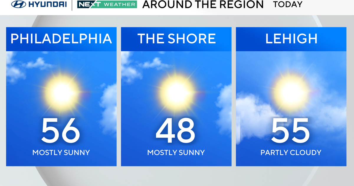
We actually will end up seeing temperatures in the I-95 corridor that push close to 60 degrees -- helping to really keep the frozen precipitation threat in the Philly metro to basically zero.
The colder air could slide into northern areas though, for example the Poconos and even sections of the northern Lehigh Valley, early enough that some rain/snow mix or even straight wet snow is potentially something to keep an eye out for.
The rain will start in the Poconos and portions of the Lehigh Valley as early as 1 p.m. and will slowly slide south as the afternoon progresses.
We should see plain rain develop across Philly and immediate suburbs around 5 p.m., meaning it's likely the commute home from work will be slow, so be prepared.
Just as the rain is moving into Philly, cold air will be pushing into the Poconos, meaning that as early as 5 p.m. we could start to see some rain/snow mix develop in those higher elevations.
The cold air will continue its push south in the early evening and wet flakes could mix with rain across the Lehigh Valley and the I-78 corridor towards the tail end of the evening, around 8 p.m. to 9 p.m.
Wet and slushy snow will begin to taper off in areas north across the Poconos as early as 9 p.m. with most of the precipitation across the whole region wrapping up by midnight.
We could potentially see a few extra raindrops along the immediate Jersey coastline until 2 a.m. but those chances are slim and the rain would be very light by that point at best.
Skies will rapidly clear as the low and cold front move away from the region, making way for a cold blast of arctic air to takeover the region.
Winds will also be picking up through the nighttime hours as well.
We should then wake up on Friday morning to dry conditions but very cold and blustery weather.
Thanks to that cold air tonight, temperatures are likely to fall below freezing in many areas including the surrounding suburbs of Philadelphia, so be on the lookout for a few slick spots on the roads on Friday morning.
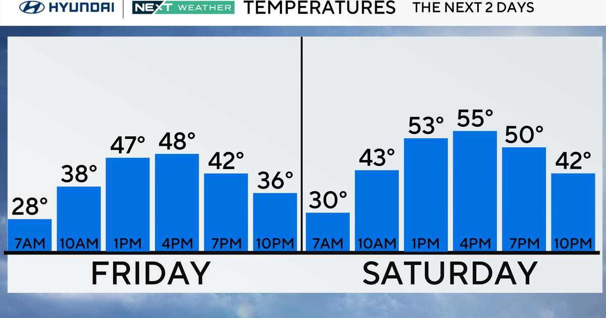
Temperatures with this system will be a wild swing.
As stated, we are likely to reach near 60 degrees in the city this afternoon, but tomorrow morning lows to start the day will be in the lower 30s. It will likely be in the 20s across the areas north and west.
While the morning lows on Friday will not approach record territory, the afternoon highs could.
On Friday afternoon, the high could hit 42 degrees in the city.
This would only be one-degree warmer than the record cold high temperature for the day -- 41 degrees in 1927.
Winds will be strong on Friday afternoon too and wind chills to end the week will be feeling like the teens across the Lehigh Valley and Poconos, and in the lower 30s for Philadelphia.
We get another shot of reinforcing cold air on Friday night into Saturday morning as lows are likely to drop into the 20s, even in the city.
Make sure you bundle up for the first half of the weekend.
After Saturday, all eyes will then turn to early next week as another early season storm system brings another chance for arctic chill and wintry precipitation in the area.
At this point the exact details are a bit too uncertain to really hash out but what we know is we are looking at timing that brings the system into the region on Monday night.
It could last throughout the day Tuesday before quickly moving out on Tuesday night.
At this time there is a chance for measurable snow in the area, but where exactly and how much are still up in the air but make sure to stay with the Eyewitness Weather Team as the details unfold over the weekend.
We also will be watching for another cold shot of arctic air in the middle of the next week where high temperatures cold potentially stay in the 30s.
Stay tuned!