Could Philadelphia heat wave give us record high temperatures? Latest weather forecast

PHILADELPHIA (CBS) -- The Philadelphia region's heat wave is well underway with no immediate end in sight. In fact, the hottest temperatures are expected over the weekend, so we've issued NEXT Weather Alert Days every day through Sunday to warn you about this heat.
We've already had our hottest day of 2024 so far on Tuesday when the mercury reached 91 degrees.
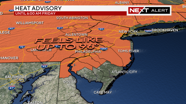
There's also a heat advisory in effect for our entire coverage area until 6 a.m. Saturday.
An excessive heat watch, signaling potential feels-like temperatures up to 105 degrees, will go into effect at 6 p.m. Friday and continue until 8 p.m. Sunday.
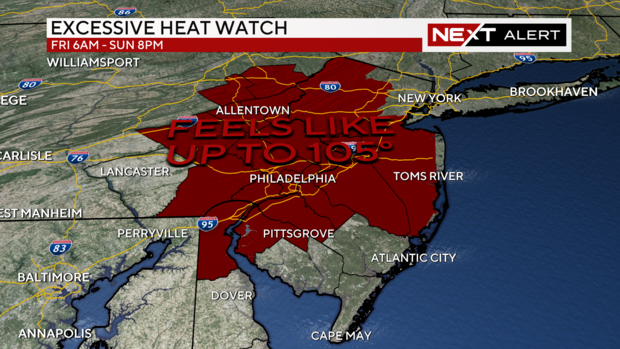
Cumberland, Atlantic and Cape May counties in New Jersey and Kent County in Delaware were left off these alerts.
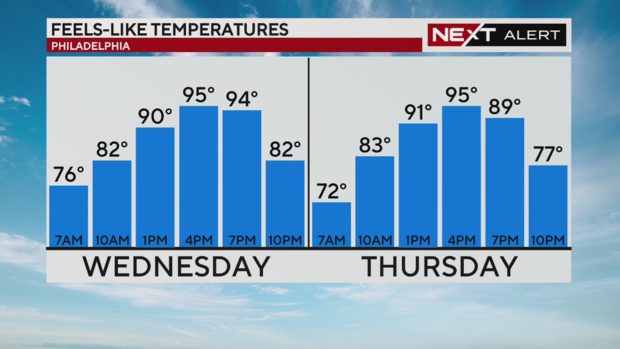
Feels-like temperatures in Philadelphia on June 19
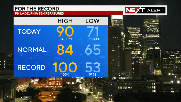
We kicked off Wednesday, the last full day of spring, with overnight lows in the 60s and 70s around the Philadelphia region. Around noon, the region hit 91 degrees — with the peak coming with a feels-like temperature of 95 by around 4 p.m.
The normal high for this time of year is 84 degrees.
Thursday is mostly the same story, with a chance of getting slightly hotter than Wednesday as the day goes on.
If you're trying to get a workout in or run errands, your best times are before 10 a.m. and after 7 p.m. - either getting ahead of the hottest part of the day or waiting for the worst to pass. No matter what, if it's hot out and you're outside, you want to drink plenty of fluids and listen to your body. More tips at this link courtesy of Meteorologist Tammie Souza and Dr. Rob Danoff of Jefferson Health.
As for rain/storm chances, the heat dome keeps us dry through Friday, with only a slight chance of showers on Friday and Saturday. A bit more unsettled weather on Sunday and Monday but no organized weather systems between now and then.
Is Philadelphia heat wave breaking records? What are the temperature records for June 19, 20, 21 in Philadelphia?
While this heat has led to alerts, we're not expecting many temperature records to be broken with this heat. Tuesday, the temperature reached 91 degrees, but the record was 96 degrees set back in 1957. Wednesday, we (thankfully) did not pass the record high of 100 degrees set on June 19, 1994.
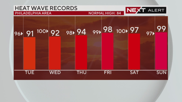
Thursday we're likely a few degrees shy of the record 98 degrees set June 20, 1931. We start getting really close to breaking a record on Friday with a forecasted high of 98 and a record of 99 degrees dating back to 1923.
Our next possible chance at a record high is Sunday, June 23, with a forecasted high of 99 degrees and a record of 97 dating all the way back to 1888.
Here's your 7-day forecast:
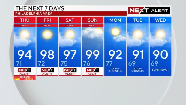
Thursday: NEXT Weather Alert for heat. High 94, Low 71
Friday: NEXT Weather Alert for heat. High 98, Low 72
Saturday: NEXT Weather Alert for heat. High 97, Low 75
Sunday: NEXT Weather Alert for heat. High 99, Low 76
Monday: High 92, Low 77
Tuesday: High 91, Low 69
Wednesday: High 90, Low 69