Air quality alert in Philadelphia area as heat wave continues; tracking rain and stormy weather Sunday

CLICK HERE for the latest weather forecast.
PHILADELPHIA (CBS) -- A heat wave that's already given us the hottest days of 2024 is back in force again on Friday, this time with an air quality alert as that heat dome over the Philadelphia region doesn't budge.
In addition to the air quality concerns in Philadelphia and the surrounding area today, there is also a heat advisory in place as potential feels-like temperatures could reach 100 degrees due to the high dew point and humidity in today's weather.
Air quality alert in Philadelphia, Pa. today: What to know
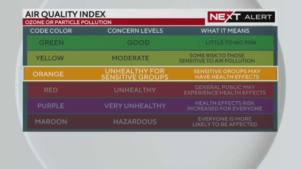
The stagnant air mass overhead is not letting ozone and particulate matter sift out of the air as it normally would. According to the Pennsylvania Department of Environmental Protection, we are under a Code Orange for ozone and will have moderate levels of PM2.5, or particulate matter less than 2.5 micrometers wide.
A Code Orange on the Air Quality Index means the air quality is unhealthy for sensitive groups like the elderly, children and people with breathing difficulties or lung conditions like asthma and COPD.
You can monitor air quality conditions at Airnow.gov or on this webpage on Phila.gov.
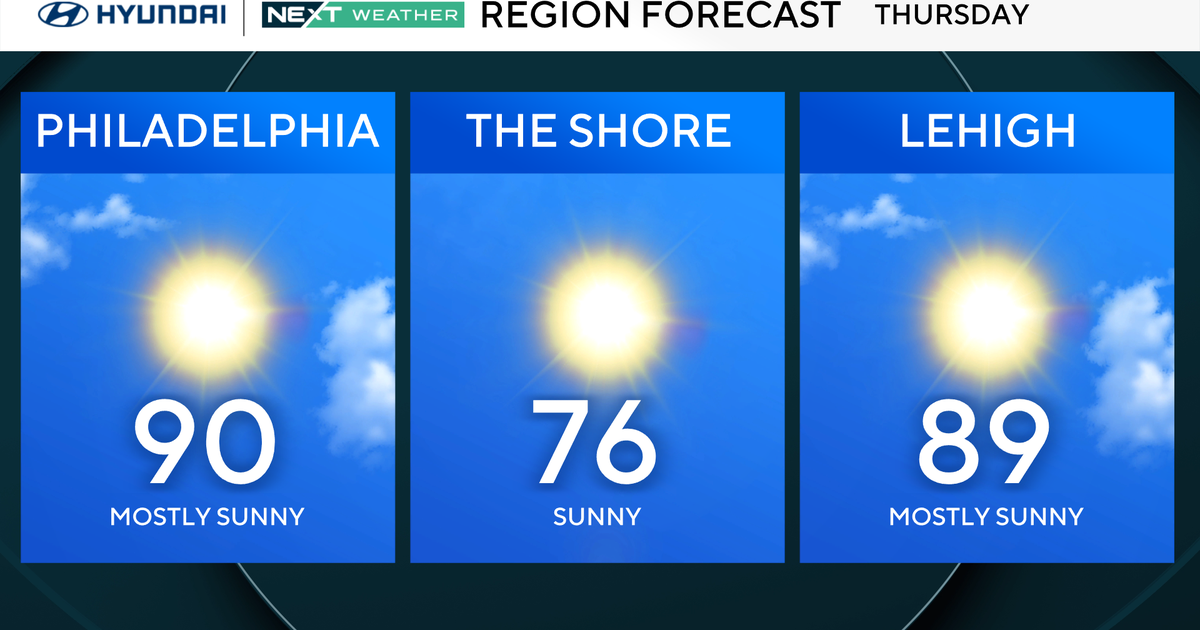
How hot will it get in Philadelphia today? High temperature, humidity and weather forecast
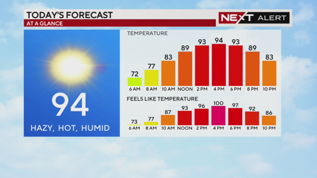
The high temperature in Philadelphia today will reach 94 degrees and it will be hazy, hot and humid. Thanks to the high dew point, that 94 degrees, which we'll reach in the late afternoon around 3 p.m. or 4 p.m., will feel more like 100 degrees. It'll still feel like the 90s until around sunset.
If you're outside the city, it'll feel a little cooler - and noticeably so at the Jersey Shore, where the high temperature is only 80 degrees.
If you're in those areas impacted by the heat advisory, remember what we've been saying all week: if you absolutely have to work or work out outside, it's safer early in the day, watch for the signs of heat exhaustion, stay hydrated and listen to your body.
We have more tips from experts on how to stay cool in the link above and in the video below.
There are also resources in the city like cooling centers and pools (which have been opening all week on a rolling basis) that you can access if you need to cool down. Stay safe!
Rain and storm chances around Philadelphia area Friday, Saturday and Sunday; Lehigh Valley under severe weather risk
On Friday, areas far north and west of Philadelphia could see high winds and rain. If there is a storm, it would be mainly confined to the Lehigh Valley and Poconos. These areas are under a Level 1 or "marginal" risk for severe weather on Friday.
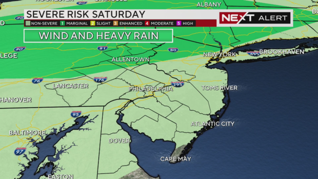
On Saturday, the entire region could see potential thunderstorms, but the only severe risk is even farther north and west of Philadelphia - still potentially impacting the Poconos and Lehigh Valley with a Level 1 risk.
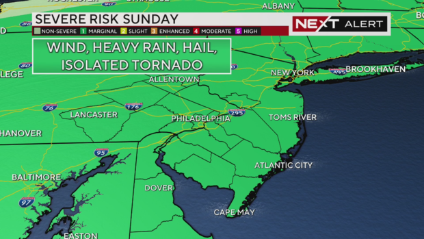
Sunday, we see the entire region under a Level 1 or "marginal" risk of severe weather that could include high winds, heavy rain, small hail and a chance of an isolated tornado. The tornado risk is low, but we will flag when conditions make them a possibility.
We could see strong storms first in the Lehigh Valley around 2 p.m. or 2:30 p.m. before more move through Delaware and South Jersey between around 5 p.m. and 6 p.m.
Storms could continue popping up in South Jersey through the evening continuing into Monday morning.
Any of these storms could produce torrential downpours, though they will provide some cooling from the day's high temperature of 98 degrees.
Stay with us as we continue tracking these storms and their arrival.
Here's your 7-day forecast:
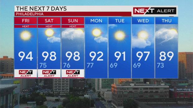
Friday: NEXT Weather Alert for high heat. High 94
Saturday: NEXT Weather Alert for high heat. High 98, Low 75
Sunday: NEXT Weather Alert for high heat. High 98, Low 76
Monday: Sunny and still warm. High 92, Low 77
Tuesday: More sun and warmth. High 91, Low 69
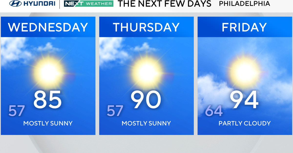
Wednesday: Back to high 90s. High 97, Low 69
Thursday: Finallly some 80s! Chance of rain. High 89, Low 73