Severe thunderstorm watch ends in Philadelphia region; cooler Monday ahead
PHILADELPHIA (CBS) -- The severe thunderstorm watch ended in the Philadelphia region on Sunday night after it was in effect for several hours.
The Delaware Valley had a slight risk for severe weather as severe thunderstorm warnings were also in effect at times Sunday night in parts of Pennsylvania, New Jersey and Delaware.
The storms brought heavy rain and wind gusts and even hail in some places.
Philadelphia area breaks several records
On Sunday, Philadelphia broke a 136-year-old record at 98 degrees. The previous record at 97 degrees was set in 1888.
Three other cities reached record-high temperatures on Sunday. Allentown set a new record at 96 degrees, and Atlantic City and Reading also reached record highs at 98 degrees.
Clouds kept the Philadelphia region from hitting 100 degrees, but our heat index hit 106.
Some parts of the Delaware Valley either broke or neared record highs on Saturday. Philadelphia came in at 98 degrees Saturday, which neared the city's record high of 100 degrees. Reading reached 101 degrees, beating its record high of 96 degrees. Allentown also heated up to 98 degrees, breaking its record high of 95 degrees.
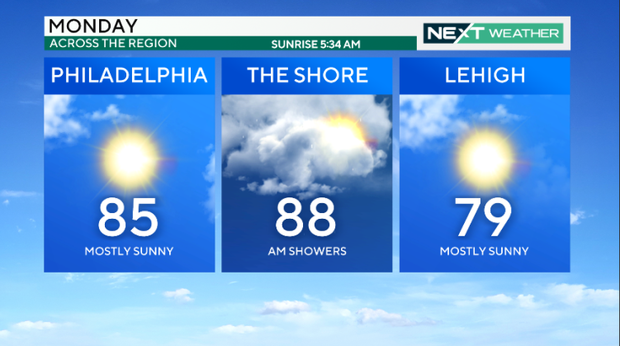
Monday is expected to break the heat wave for one day due to wet weather that will cool down the region.
Philadelphia to end heat emergency
The city of Philadelphia will end a heat emergency on Sunday night that has been in effect since Thursday morning, as the region dealt with an intense heat wave.
The emergency activated cooling centers, home visits by special field times, enhanced daytime outreach for people experiencing homelessness and the Philadelphia Corporation for Aging's Heatline.
"While we are still in a heat emergency today in Philadelphia, I do want to thank all the city workers in all the agencies that have worked tirelessly this last week to help keep our residents safe and cool during these extremely high temperature days," Mayor Cherelle L. Parker said in a statement. "We're not out of the heat emergency just yet, so please, stay cool, keep hydrated, take advantage of city resources like swimming pools and neighborhood cooling centers. And keep checking in on your neighbors."
Here's your 7-day forecast:
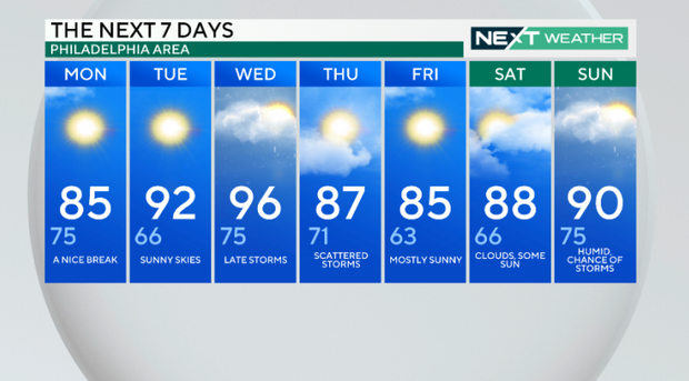
Monday: High 85, Low 75, a nice break
Tuesday: High of 92, low of 66, sunny skies
Wednesday: High of 96, low of 75, late storms
Thursday: High of 87, low of 71, scattered storms
Friday: High of 85, low of 63, mostly sunny
Saturday: High of 88, low of 66, clouds, some sun
Sunday: High of 90, Low of 75, humid, chance of storms