NEXT Weather: Eagles game forecast and the freezing week ahead
PHILADELPHIA (CBS) -- We might as well just come out and admit that we've been spoiled with the weather lately, as 70s were more common than 50s or 60s for most of November in the Philly region so far. Get ready, because all of that comes to a screeching halt for the week ahead.
Let's start with Monday: A Freeze Warning is in place from midnight through 8 a.m. for much of the Philadelphia metro. Overnight lows will be in the range of 27 degrees to 34 degrees. This will be a killing freeze, so if you have any late-season plants still outside, they need to be brought in.
On the bright side -- literally -- we're expecting plenty of sunshine for your Monday everywhere, so in addition to the jackets, sweaters and gloves, add sunglasses to your weather accessories list. Highs will be in the middle and upper 40s Monday afternoon. High pressure settles on Monday afternoon, keeping us mainly clear with lighter winds as well.
Go Birds!
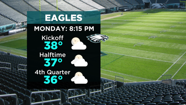
The Eagles take on the Commanders Monday Night, with an 8:15 pm kickoff, and temperatures in the upper 30s. If you're heading to the game, it'll be dry, but cold, with fourth quarter temperatures in the middle 30s. Expect increasing, thickening clouds on the way home.
Mid-Week Headaches
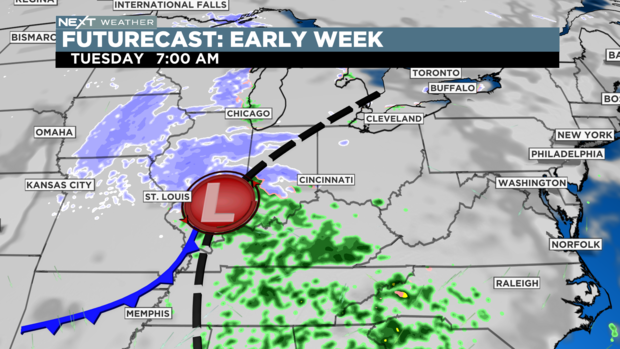
As clouds increase early Tuesday morning behind departing high pressure, all eyes are going to be focused on low pressure arriving from the Ohio Valley. This storm system has a ton of moisture with it, so expect rain to begin late Tuesday afternoon southwest, and move across the Philadelphia metro Tuesday night. While most areas will receive rain, enough cold air will be in place for the Lehigh Valley, Allentown and Mt. Pocono to have this all start as a wintry mix and light snow. There might be a little slushy accumulation, but milder air moving in should change it all to rain overnight into Wednesday.
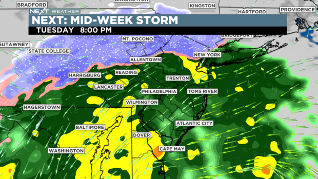
Bands of heavy rain are not out of the question for most of the area into the wee hours of the morning. While flash flooding isn't a concern right now, we could see some issues, especially in areas with poor drainage.
Rain retreats with decreasing clouds late Wednesday as the system pulls out to our north and east.
Second Shot Of Cold
While we clear up and dry out late Wednesday, another reinforcing shot of Canadian air moves into the Delaware Valley.
Thursday and Friday are both mostly sunny and colder; highs will range from the low to middle 40s for Philadelphia, to the 30s for the mountains to the north. Overnight lows — even in the city — could be as cold as 26 degrees.
For the latest on the busy week of weather ahead, keep it tuned to CBS3 Eyewitness News and the NEXT Weather team. Don't forget to download our FREE CBS3 Weather app as well, to stay up to date on the cold, the rain and (if you're in the Lehigh Valley) the snow!