NEXT Weather: Storm system to hit Philly region before Christmas
PHILADELPHIA (CBS) -- The week ahead in the Philadelphia region will no doubt be a busy one, with school wrapping up for the semester, last-minute shopping trips and for some of you -- holiday travel. The good news is that the beginning of the week looks quiet, dry and sunny. The bad news? The end… well, that's a totally different story.
Monday brings a pretty broad area of high pressure to the Delaware Valley, so expect sunny skies. As fresh Canadian air filters in, winds out of the west will kick up at 15-25 mph. This means highs in the low 40s will feel more like the upper 20s and low 30s for most of the day.
Through Wednesday, expect much of the same: mostly sunny skies, chilly temperatures but quiet weather.
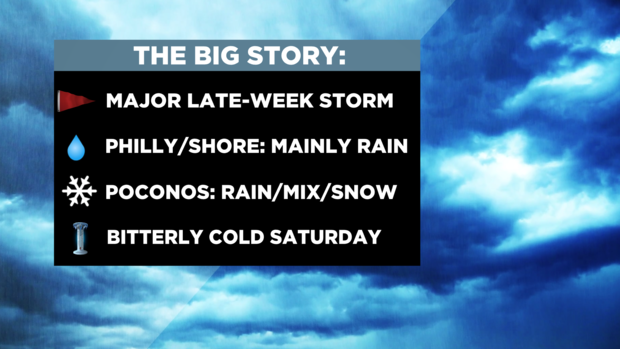
Late-week headaches
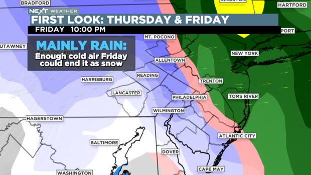
By Thursday, a powerful and very complex storm system out west will move in, dramatically changing our weather for the end of the week. The most important aspect as to what kind of precipitation we get is the placement of the center of low pressure.
The general rule is: further out to sea (aka coastal storm): colder air northwest of it gets dragged in, giving us a better shot at snow. Further inland, and we'll bring up more of a southeast flow of air; warmer winds off the ocean that will help keep most of it as rain.
In our case, the second option looks more and more likely. While there could be a brief flurry or some sleet in Philadelphia to start, Thursday and Friday will be rain for the city, heavy at times. Temperatures will rise into the upper 40s and low 50s during this time as well.
Further north, the Lehigh Valley could initially see a bit of a mix before changing to rain, while the Poconos will see several inches of accumulating snow.
As the system finishes pulling out to our northeast, the question becomes: How much precipitation lingers behind the system to interact with the incoming Arctic air? That will answer whether or not Philadelphia sees a few brief snow showers Friday night into early Saturday to cap the system off. Stay tuned.
Christmas arctic blast
Once the storm system leaves us, sunny skies return for Saturday and Sunday (Christmas) but wow, will it be cold! A large area of high pressure from the Arctic moves in, putting much of the country in a deep freeze for several days.
In Philadelphia, Saturday and Sunday morning lows could be in the teens, while highs will only stay in the 20s.
Make sure to get all your winter accessories out because winter is not playing around next weekend!