Dense fog advisory lifted in Philadelphia region; how Helene's remnants affect us
PHILADELPHIA (CBS) -- The next several days will bring similar weather conditions, day in and day out around the Philadelphia area. That means mostly cloudy skies, off-and-on showers and humid conditions as the moisture from Helene heads this way.
The center of Helene is drifting westward today and will not fully clear the east coast until at least Tuesday of next week, keeping us in a cloudy, unsettled pattern.
Hurricane Helene made landfall late Thursday night over the Apalachee Bay, near the mouth of the Aucilla River, as a dangerous and massive Category 4 storm with wind speeds of 140 mph.
The storm surge flooding has been catastrophic with some spots in the Big Bend area reaching 15-20 feet of water pushed on top of land surfaces from the Gulf. The Tampa area has also recorded record storm surge flooding of around 8 feet, causing damage to many homes and businesses.
Tropical Depression Helene latest path, track, effects on Philadelphia area
Now a Tropical Depression, Helene was pushing into Tennessee on Friday morning and then drifting west toward the Mississippi Valley, but outer bands of clouds and showers will lift far enough north to impact our area starting this afternoon, with the heaviest band of tropical showers arriving overnight.
This is when our greatest impact from Helene will occur, with localized tropical downpours bringing as much as a half-inch to an inch of rain to parts of the area overnight into the weekend.
As the storm stalls over the mid-South, we may dry out for some of the weekend as dry air noses in, but the upper low that will absorb Helene will slowly drift through the eastern half of the country through the early part of next week.
This means that while none of our days from Saturday on look like washouts, we'll keep it cool and cloudy with shower chances each day (possibly peaking on Tuesday) until a cold front brings a much-needed pattern change by the middle of next week.
The NEXT Weather team will continue to monitor this Helene as well as any other chance of rain throughout the week to help you plan for any potential impacts.
Here's your 7-day forecast:
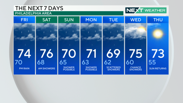
Friday: NEXT Weather Alert for fog. Cloudy, with rain chances late. High 74
Saturday: Shower chances, mostly cloudy. High 76, Low 68
Sunday: Shower chances and clouds. High 70, Low 65
Monday: High 71, Low 63
Tuesday: High 69, Low 62
Wednesday: High 75, Low 60
Thursday: Sunshine? High 73, Low 55