Excessive heat warning in Philadelphia area ends, parts of region could see severe weather

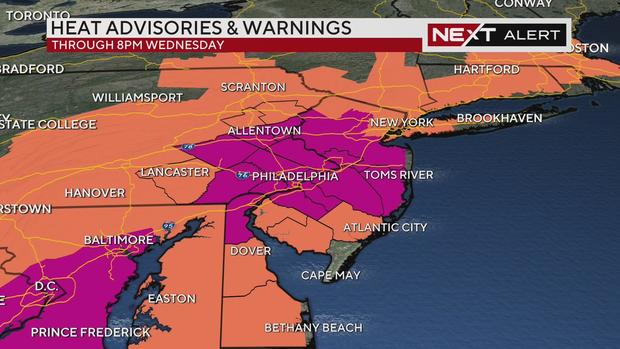
PHILADELPHIA (CBS) -- We remain under a Next Weather Alert for dangerous heat and humidity Wednesday. An excessive heat warning ended at 8 p.m. for most of the Philadelphia region.
A heat advisory for southern Delaware and Atlantic, Cumberland and Salem counties in South Jersey also ended at 8 p.m.
Because of the cumulative effect of warm nights and hot days it is important to stay hydrated and stay cool. Don't forget the pets, they need shade or an indoor space with cool water.
Do you know the difference between an excessive heat warning and a heat advisory? And did you know different parts of our region have different criteria to trigger these alerts?
Under the same feels-like temperature of 106 degrees, Camden County would be under an excessive heat warning, while Atlantic County would be under a heat advisory.
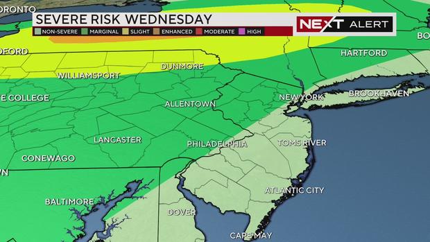
Marginal risk for severe weather tonight
Southeastern Pennsylvania and the Lehigh Valley are also under a marginal risk for severe weather, or level 1 of 5, for Wednesday night. Scattered storms will develop in the late evening and through the overnight hours as a cold front stalls across the area.
Moisture from Beryl, which as of Wednesday morning is considered a post-tropical remnant low and no longer a depression, could also dip into the region and bring the threat of heavy rain, flash flooding and a damaging wind gust overnight. There is a tornado threat farther north and west near the Poconos.
The system will have weakened by the time it reaches the city around midnight to 1 a.m.
Much of Thursday will be dry with only isolated showers or storms along the coast as the front stalls. That front works its way back inland on Friday and will provide the focus for showers and storms, some of which will produce localized flooding concerns. The showers and storms may linger into Saturday morning before ending.
Friday will be our only day of relief from the heat, with highs in the low 80s. By Saturday and Sunday we rebound back to the 90s and early next week, high temperatures could again approach the upper 90s.
Philadelphia racking up 90-degree days
Philadelphia averages 30 90-degree days each year. So far in 2024 we've already had 17 90-degree days, and most of our hot season is still ahead of us. In 2023, there were 24 90-degree days. This is also our 8th consecutive month of above average temperatures.
Stay with the NEXT Weather team for the latest updates on the heat, the remnants of Beryl, and any storms.
Here's your 7-day forecast:
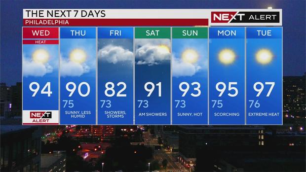
Wednesday: High of 94, NEXT Weather Alert
Thursday: High of 90, low of 75, sunny and less humid
Friday: High of 82, low of 73, showers and storms
Saturday: High of 91, low of 73, AM showers
Sunday: High of 93, low of 73, sunny and hot
Monday: High of 95, low of 75, scorching
Tuesday: High of 97, low of 76, extreme heat