Humid, hot weather with heat advisory around Philadelphia area; rip current risk at Jersey Shore
PHILADELPHIA (CBS) — Expect even hotter and still humid weather in the Philadelphia area on Thursday, as we enter the second day of what could be a four-day heat wave.
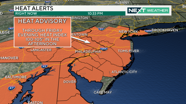
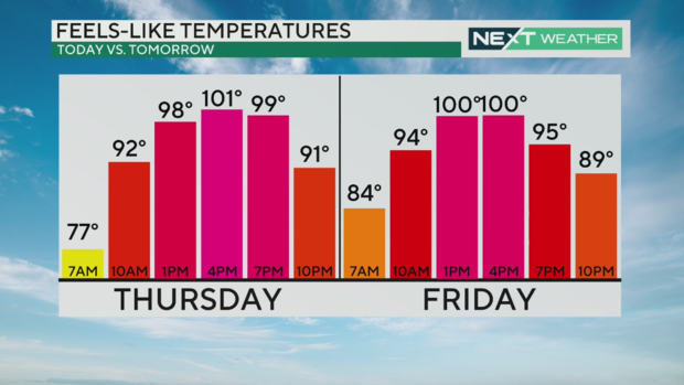
We're expecting a high temperature of 95 degrees in Philadelphia, with a little bit cooler temperatures at the Jersey Shore. Factor in humidity with all that heat, and the feels-like temperature could be as high as 105 degrees Thursday.
Nearly our entire region, except for Cape May County, is under a heat advisory for this reason.
The muggy meter (the dew point) will dip slightly Thursday afternoon, and this influx of dry air should limit chances of storms today.
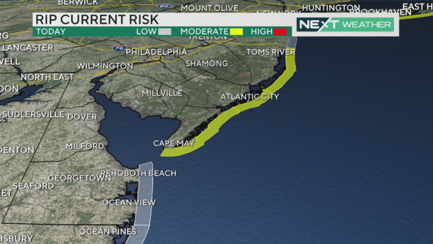
There is also a moderate risk of rip currents along the Jersey Shore. Be sure to only swim at guarded beaches. If you're caught in a rip current, don't fight it and don't panic — swim parallel to the beach until you can break free.
Now back to your forecast: Friday is steamy and brings more cloud cover as a front slowly moves through over the weekend. We'll start Saturday with sun, and then storms fire up to the west in the afternoon and evening, and that pattern will repeat on Sunday.
We don't really get rid of this humidity until Monday — which will still be hot — but then Tuesday and Wednesday are more seasonable and far less muggy.
You have probably heard about the giant wildfires across California, Oregon, Canada and now Colorado. Hundreds of thousands of acres have burned, destroying homes, towns and state and federal forests. Sadly, the largest fire in California, the Park Fire in Chico, was caused by arson.
Smoke from the Park Fire is so thick that it is visible on satellite imagery and we may see signs of the smoke all the way here, thousands of miles away. While it will NOT be like last summer with thick, dense smoke at the surface, watch for a "milky" sun and darker colors around sunrise and sunset.
Smoke in the atmosphere scatters more light waves so we end up seeing only the longer waves — the reds and oranges.
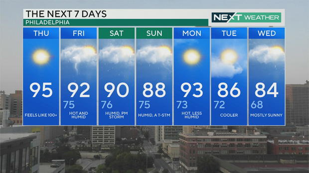
Here's your 7-day forecast
Thursday: High of 95. Feels like 100+
Friday: High of 92, low of 75. Few storms
Saturday: High of 90, low of 76. Some sun, then PM storms
Sunday: High of 88, low of 75. Isolated shower
Monday: High of 93, low of 73. Shower chance
Tuesday: High of 86, low of 72. Mostly sunny
Wednesday: High of 84, low of 68. Partly cloudy
Get the latest weather info on the CBS News Philadelphia app
