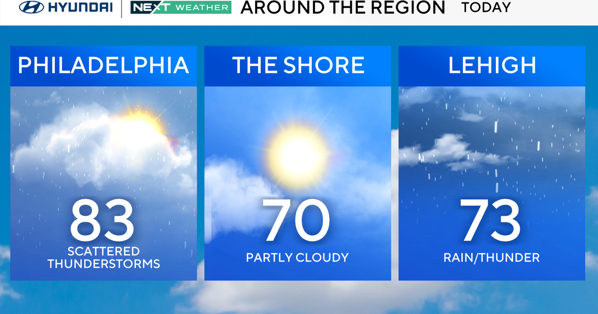
NEXT Weather: Rain to move through Philly area overnight after winter storm
PHILADELPHIA (CBS) -- A major system from the southwest will rolled through the Philadelphia region Wednesday.
It brought snow, rain and wind to parts of the Delaware Valley.
The Poconos and the Lehigh Valley got some snow, while the northern suburbs like Montgomery and Bucks Counties got a wintry mix.
The city didn't see any snowfall, just heavy rain that will continue through Wednesday night.
Localized flooding will be a concern as rain becomes heavier.
But there's good news: It'll be a dry, sunny day on Thursday.
PennDOT treating highways and roads as storm moves through Philly area
Rain washes away snow in Allentown
ALLENTOWN, Pa. (CBS) -- Wednesday's weather brought a quick shot of snow to the Lehigh Valley. In Allentown, the flakes came down fast, but didn't last very long.
Snow was falling just before noon in Allentown, and then that change over to rain happened Wednesday evening.
So the snow was short-lived, but it provided a lot of joy to many people and kept road crews very busy.
The snow started falling fast in the Lehigh Valley, covering sidewalks and some streets in a hurry.
Cree Banks ventured outside, pushing her kids in a covered wagon and enjoying the snow for the first time this winter.
"We figured we would take the kids out since there hasn't been a whole lot of snow recently," Banks said.
But Wednesday afternoon, the flakes started falling around noon in Allentown.
It was a welcome sight for those who love winter like Nicole Haymaker. She's still hoping for a major snowfall.
"As long as we get one good one, I'll be happy," Haymaker said. "I don't care when it is."
"It's good to see it from a picturesque perspective," Matt Trust said. "It's pretty nice, but it's nice in small doses, so hopefully we have this and not a whole lot more in the future."
"I'm originally from California so I'm not used to the snow at all, so I love the snow," Celene Gerhard said.
Many people broke out the shovels and brushed off their cars as road crews work around the clock to keep the roads clear.
PennDOT has 200 drivers around the region throwing down salt and monitoring possibly dangerous conditions during the evening commute.
"With the ground being cold when the rain hits it, it could freeze up so we want people to realize that although it looks wet out there later today in the early afternoon and early evening it still could be a thin film of ice on the road surface," Ron Young, of PennDOT said.
If you're heading out Wednesday night, be aware of any possible black ice, or depending on where you live -- ponding from the rain.
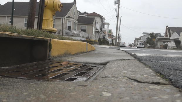
Jersey Shore workers brace for rain, wind
MARGATE, N.J. (CBS) -- This system will produce heavy rain and gusty winds for the Jersey Shore. In Margate, CBS News Philadelphia spoke with workers, first responders and homeowners as they prepared for the rain and wind.
The rain started coming down in Margate a little before 2 p.m. Wednesday. This intersection, Winchester and Granville Avenues, typically floods during heavy rain.
Right now, it's clear, just slick, but homeowners are preparing for it to flood Wednesday night.
"Over there, it's not uncommon for it to be above your knee," John Burd said.
Burd says when this road is at risk of flooding, neighbors here help each other out.
"One of the big things is really making sure all of our trash cans and lawn furniture is put to the back of the houses," he said.
Despite the rain, Rick Zemanik of Ricky Z Custom Painting says it won't stop his crew from completing their work, and it helps working inside so none of their equipment is exposed to the elements.
"No fear, man," Zemanik said. "Rain, snow, shine. We work all the time."
Though Zemanik is worried about what will happen once they finish up and head home.
"We're about 30 miles up the road and I keep an eye on it," Zemanik said. "Long as there's no tidal flooding that we have to worry about, getting in town and low areas."
The evening commute home for workers like Zemanik is what most concerns Atlantic City Battalion Fire Chief Mike Famularo.
"Take your time. Keep space between your cars," Famularo said. "You're following too close behind a car, not only are you getting the heavy rain, you're getting the rain coming off the tires."
Loose items are also a big concern for Famularo.
"Light items, loose items in your yard, outside, if you can bring them in, bring them in, just so stuff's not blowing around," Famularo said. "I mean, 47 miles per hour gusts, light material will be blowing around."
They're expecting some ponding on several low-lying roads and they have their high-water vehicles on stand-by.
Wet snow falling in Bucks County
PennDOT crews prep for icy roads during evening commute
ALLENTOWN, Pa. (CBS) -- Road crews have done a nice job getting ready and pre-treating the roads before this storm arrives. We aren't expecting a major storm here in the Lehigh Valley but we can see some accumulation.
PennDOT says it has 200 trucks spread out across the region right now and over the past two days crews have been out pre-treating the roads with salt brine. The main concern is possibly some freezing on the roads later Wednesday which could be a little tricky during the evening commute.
It's been a very mild winter for these crews.
"We do have concerns with the ice conditions because the event's supposed to be snow and it changes over to either ice and then rain or just the rain," PennDOT spokesperson Ron Young said. "But with the ground being cold when rain hits, it could freeze up."
"So we want people to realize that even though it looks wet out there, later today and in the afternoon and early evening, that it could be the same film of ice on the road surface."
The good news when it comes to budgets, PennDOT hasn't had to spend a lot of money buying salt and other materials but they do expect to have a busy day.
Snow falling in Bethlehem
NEXT Weather: Rain moves in
Schools closing, going virtual, dismissing early due to weather
Districts in our region are closing or going virtual due to the storm.
Closed
Bethlehem Area School District is closed Wednesday, according to the district website.
East Penn School District is closed.
Parkland School District is closed.
Salisbury School District is closed.
Whitehall-Coplay School District is closed.
Nazareth Area School District is closed.
Wilson Area School District is closed.
Boyertown Area School District is closed
Oley Valley School District
Virtual
The Allentown School District announced on Twitter that it would have virtual school Wednesday.
Reading School District will be virtual.
Catasauqua Area School District will be virtual.
Easton Area School District will be virtual.
Northern Lehigh School District is virtual.
Northwestern Lehigh School District is virtual.
Bangor Area School District is virtual.
Northampton Area School District is virtual.
Antietam School District is virtual.
Brandywine Heights Area School District
Fleetwood Area School District
Hamburg Area School District
Kutztown Area School District
Muhlenberg School District
Wyomissing Area School District
Early dismissal
Wilson School District
Lehigh Valley drivers are ready for this winter storm
WHITEHALL TOWNSHIP, Pa. (CBS) -- We're continuing to track conditions this morning as a winter weather advisory goes into effect for several counties in our area, including Lehigh.
Wednesday morning, it seems most people are prepared for what's coming.
On the drive out here we saw multiple road signs warning drivers of the winter weather coming today and urging them to plan accordingly.
Before you hit the road this morning, it's a good idea to have your scraper and emergency kit handy just in case.
So far the big takeaway from drivers is that it's been a weird winter.
"I like the snow, I love winter," driver Cindy Lapp said. "I think if it's going to be cold, I'd rather see snow, than dead stuff all over the place, it just looks prettier to me."
People are saying: bring on the snow!
The storm hour by hour, region by region
Does snow stick?
While a few snowflakes are possible for Philadelphia, accumulation is unlikely. Warm air moved into the region ahead of the main front, pulling us into the 40s, and changing the precipitation to rain. For Philly, this is a big rain and wind event, with a very treacherous evening commute likely. Rain amounts could exceed 1.5 inches, resulting in flash flooding.
Southern Jersey and the shore are likely to experience an all-rain event, with torrential downpours through the early evening. Combine this with the wind, and it's advisable to avoid being out throughout much of the day, if possible.
Rain will eventually become steady Wednesday afternoon and into the evening commute.
As for the snow, expect a coating at best in the city, with 2-4 inches in the Lehigh Valley, and 4-6 inches in the Poconos, before the late-day changeover to rain. With increasing temperatures, much of the accumulating snow, even in the mountains, should wash away before the system exits the area early Thursday.
When do snow, rain arrive in our region?
The good news is that the morning commute will be OK, with dry air making it difficult for much of anything to reach the ground early on. In fact, even later commuters should see rain and snow-free roads through at least 9:30 a.m. to 10 a.m. By the late morning, the system will start sending snow to the Lehigh Valley and a few flurries to the Philadelphia area.
Farther south and east, precipitation along southern New Jersey and the shore will start and remain all rain.
North of I-78, cold enough air will allow the snow to stick. This will last through the afternoon before the warmer air arrives.
For everyone, precipitation leaves us late Wednesday night in the form of a few sprinkles and showers, with some clearing likely by Thursday morning.