El Niño is going to continue through spring 2024, forecasters predict
Forecasters say there could be months still to go before the culmination of El Niño, a climate pattern characterized by higher sea surface temperatures and precipitation across the equatorial Pacific Ocean that can affect weather across the globe.
The warm phase of an oscillating cycle that recurs every few years, El Niño officially arrived in June, and at the time scientists anticipated that the phenomenon would likely continue into the latter part of 2023. Now, in an updated outlook released Thursday by the National Weather Service's Climate Predication Center, forecasters said there was an 80% chance that El Niño would persist into the Northern Hemisphere's spring season and linger until May of next year.
There is also a high probability that El Niño will become stronger than usual as it finishes out its current run, which could mean its mark on winter temperatures as well as rain and snow patterns around the world may be more evident, the National Oceanic and Atmospheric Administration said.
El Niño is one half of the alternating El Niño-Southern Oscillation, or ENSO, cycle, a shifting system of contrasting climate phenomena dictated by trade wind patterns and their resulting effects on sea surface temperature in a block of the equatorial Pacific Ocean south of Hawaii. El Niño replaces its inverse, La Niña, the cycle's colder stretch. Both phases of ENSO are defined by sea surface temperatures and precipitation in that section of the Pacific that depart from what is considered the neutral norm. An increase in temperatures and precipitation levels corresponds with El Niño, and the opposite is true for its counterpart.
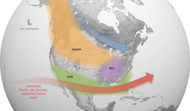
The extent to which El Niño affects global weather patterns depends on its strength. The warmer ENSO phase has intermittently disrupted marine ecosystems and can wield significant influence over the weather in the United States, where El Niño is typically associated with wetter conditions along the Gulf Coast and in the Southeast that sometimes cause serious flooding. This phase of the climate cycle generally brings warmer and dryer weather to northern parts of the U.S. as well as Canada.
So far in 2023, El Niño's effects on the U.S. climate have not unfolded exactly as its past activity might suggest.
Last July marked the fourth consecutive month of record-high global ocean surface temperatures, and it also had the highest monthly sea surface temperature anomaly in NOAA's 174-year record, the agency said, acknowledging that all of that could be related to the characteristic warmth seen in El Niño.
But the atmospheric conditions normally created by this phase, which tend to help decrease tropical activity during Atlantic hurricane season, developed slower than anticipated. Hurricane season lasts annually from June until November, and this one was more active than normal, even though it is usually La Niña that corresponds with increased hurricanes in the U.S.
"Depending on its strength, El Nino can cause a range of impacts, such as increasing the risk of heavy rainfall and droughts in certain locations around the world," said Michelle L'Heureux, a climate scientist at the Climate Prediction Center, in a statement announcing El Niño's impending arrival earlier this year.
"Climate change can exacerbate or mitigate certain impacts related to El Niño," said L'Heureux. "For example, El Niño could lead to new records for temperatures, particularly in areas that already experience above-average temperatures during El Niño."
The effects of El Niño usually strengthen heading into the fall and winter seasons, scientists say, so the next few months could bring increased rainfall and snow to certain places as long as the climate pattern remains in place. How its true effects will take shape may be somewhat unpredictable, according to NOAA, which noted that changing global climate "means this El Niño is operating in a different world than earlier El Niño events."


