Colorado Weather: Winter storm will create extreme impacts in parts of the state
A storm moving from California to Colorado on Monday will bring snow, wind, and much colder temperatures. The plains will experience a blizzard.
Denver and the Front Range urban corridor should be spared the worst of the storm and will likely only get 1-4 inches of snow mostly Monday night.
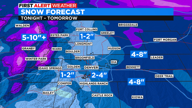
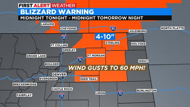
It's a different story on the Eastern Plains for the first BLIZZARD WARNING of the season has been issued from midnight Monday night through midnight Tuesday night. The combination of up to 10 inches of snow together with 60 mph wind gusts will cause whiteout conditions on the plains and could prompt road closures. Portions of I-76 and/or I-70 east of the Denver metro area could be closed for long periods of times by Tuesday morning.
Colorado's mountains will also get a significant amount of snow but over a longer duration and with less wind compared to the Eastern Plains. Therefore most mountain areas in Colorado only have a Winter Weather Advisory through 5 p.m. Wednesday for about 5-10 inches of snow at most ski areas.
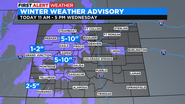
The exception in the high country is the southern San Juan Mountains in southwest Colorado where up to 14 inches of snow is possible at Purgatory, Silverton, and Wolf Creek.
The storm will leave Colorado on Wednesday and the weather story for the remainder of the week will be the cold temperatures. Even for the middle of December (normally the coldest time of year in Denver), high temperatures will stay below normal each day through the weekend and most days should stay below freezing.