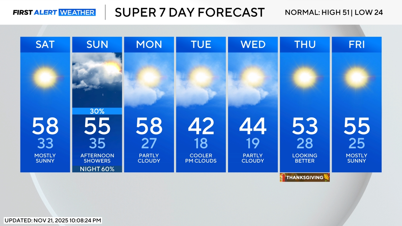
Colorado Weather: First genuine cold front of the season arrives soon, mountain snow likely
Denver and the Front Range will experience one more unusually warm day on Monday before a strong cold front brings quick changes.
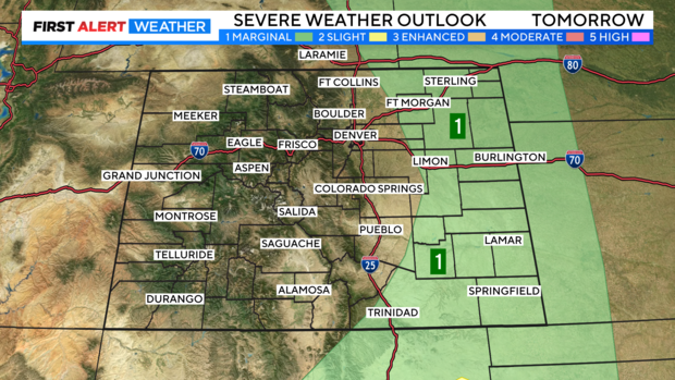
Related: Get Monday's updated severe weather forecast
After the setting a big record with 91 degrees in Denver on Saturday, the urban corridor wasn't much cooler on Sunday with an official high temperature of 86 degrees at the airport.
Monday will be similar with 80s along the Front Range and above normal temperatures again statewide. Wind gusts could reach at least 40 mph at times keeping the fire danger elevated.

Then a strong cold front that was moving south over Wyoming on Sunday will slowly reach the Denver metro area by Monday evening. The front may trigger a few gusty thunderstorms that produce more wind than rain mostly after 4 p.m. on Monday. Farther east, some storms could produce wind strong enough to do significant damage and therefore the far eastern plains of Colorado are under a slight risk of severe weather late Monday (1 of out of 5 on the threat scale).
For Denver and the Front Range, the most significant change will be the temperatures will more than a 20 degree drop in high temperatures from Monday to Wednesday. Any moisture around Denver, Boulder, and Fort Collins Monday, Tuesday, and Wednesday should be limited.
It could also get just cold enough in the metro area Wednesday night for the first patchy frost of the season. However there is no threat of a freeze at lower elevations this week.
It's a different story in the mountains where a Freeze Watch has been posted for Monday night across northwest Colorado. Some areas like Craig and Meeker have already experiences several freezing nights this season but generally the temperature had dropped no lower than 28 degrees. That could change Tuesday morning.

The high country will also experience one of the first accumulating snowfall events of the season starting Monday afternoon and mainly south of the I-70 mountain corridor. At this time, no more than a couple inches of snow is expected mostly above 9,500 feet from Monday afternoon through Wednesday afternoon.

Sunshine and gradually warmer temperatures will return later in the week.