Several rounds of storms possible with hail, damaging winds, flooding in North Texas

NORTH TEXAS — Our CBS News Texas First Alert Weather team is forecasting several rounds of storms Thursday and Friday.
A severe thunderstorm warning is issued for Dallas and Tarrant counties until 11:45 p.m.
Thunderstorms will move through North Texas in the afternoon with another round expected Thursday night. Some may be severe with large hail and damaging winds. Heavy rain may also produce flooding in some areas.
Click here for the metroplex radar loop.
The National Weather Service expanded the flood watch to include all of North Texas. The Flood watch is in effect until Friday evening.
The ground is very saturated and runoff can occur easily as more rain moves in Thursday night and Friday morning.
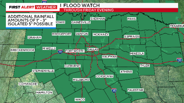
An additional 1"-3" of rain is possible with some localized 5" not out of the question.
Remember to turn around and don't drown. Never drive on a road covered by water.
Depending on how long the storms linger into this afternoon/early evening, we'll be watching for another threat of severe storms overnight. The best chance for impacts in DFW is 1 a.m. to 7 a.m.
If this line were to materialize and move through, that would likely warrant dropping our rain/storm chances on Friday a bit.
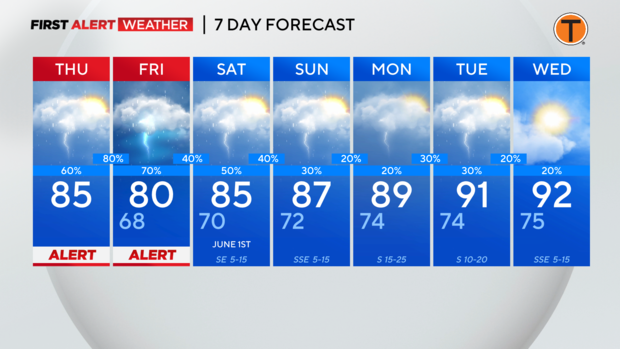
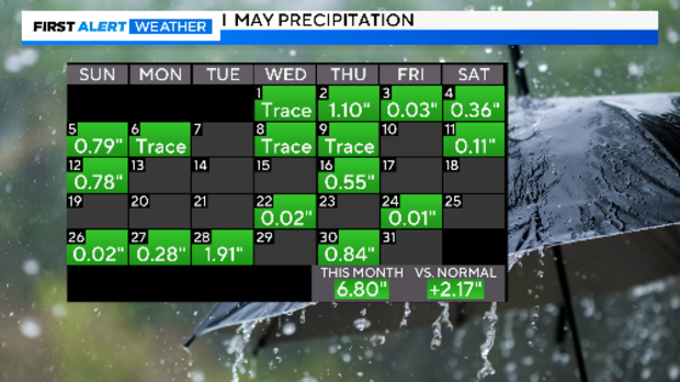
We have seen nearly 7" of rain this month and our monthly total is more than 2" above average. We look to end May with more rain on the way and start June with showers and storms in the forecast.