Record low temperatures are possible in North Texas Thursday morning

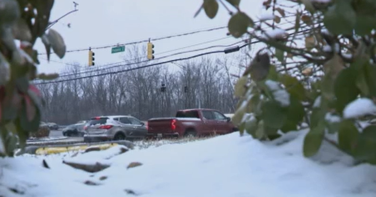
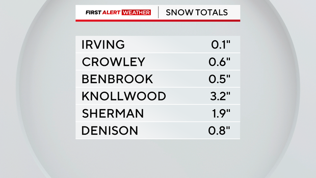
NORTH TEXAS — We were lucky to not have many issues on the roads due to winter precipitation from our arctic front. But the big talker was the lake effect snow – take a look at some of the snowfall totals provided by the National Weather Service out of Fort Worth.
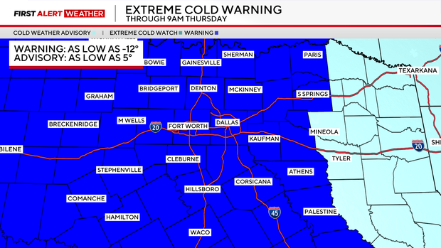
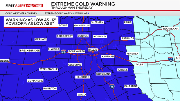
An extreme cold warning continues for most of North Texas heading into Thursday morning.
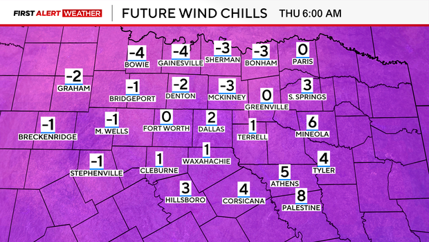
Decreasing clouds Wednesday night and gradually decreasing winds mean temperatures will plummet with lows in the teens and single digits. Wind chills will range from -5° to 5°.
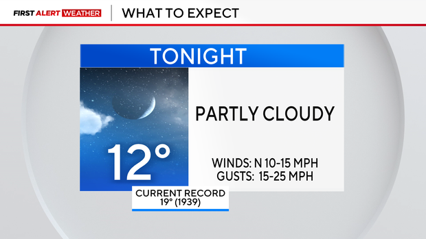
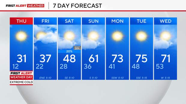
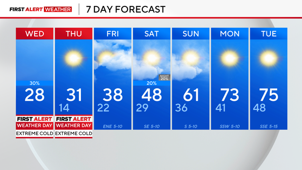
Not only is our high of 27° on Wednesday a new record-cold high, but we're expecting to break Thursday's record low, as well.
Frigid temperatures and dangerous wind chills continue through Thursday morning. Wind chills will be low enough to damage interior and exterior plumbing. Winds will weaken Thursday afternoon and temperatures will warm into the 20s.
We're expecting to remain below freezing until midday Friday.
There is another chance for rain on Saturday with an isolated, low chance of freezing rain in Central Texas on Saturday morning.
(ORIGINAL STORY) — A very cold Wednesday is in store for North Texas, with several weather alerts in effect. CBS News Texas meteorologists have issued First Alert Weather Days through Thursday.
An extreme cold warning is in effect until 9 a.m. Thursday. It includes all of North Texas. Counties further east, including Wood, Smith and Anderson, are under a cold weather advisory.
Wind chills on Wednesday could drop "feels-like" temperatures to -12 degrees in some parts of North Texas. Winds could gust up to 35 mph. Dress up in layers, limit time spent outdoors and protect exposed skin.
The temperature at Dallas-Fort Worth International Airport Wednesday morning dropped to 13 degrees while it was 14 degrees at Love Field Airport. This was the coldest morning in North Texas since temperatures dropped to 11 degrees on Jan. 15 and 12 degrees on Jan 16.
Between 5 a.m. Tuesday and 5 a.m. Wednesday, temperatures across North Texas dropped by nearly 40 degrees.
The dangerous cold weather continues on Thursday, with temperatures in the teens but feeling like single digits.
Record low temperatures are possible Thursday morning with a forecast low of 14 degrees. The record low temperature on that date is 19 degrees, set back in 1939. But Texas will be Texas and temperatures will be back into the 70s for highs starting next week.
Despite the cloud cover clearing on Wednesday and ample sunshine in the forecast Thursday, North Texas' high temperature won't warm above the freezing mark Thursday. The latest forecast looks to have the high temperature warm above freezing around late Friday morning.
There is another round of light rain possible on Saturday but it is minimal coverage at best. The thaw continues into next week with high temperatures warming into the mid-70s by Monday and Tuesday.
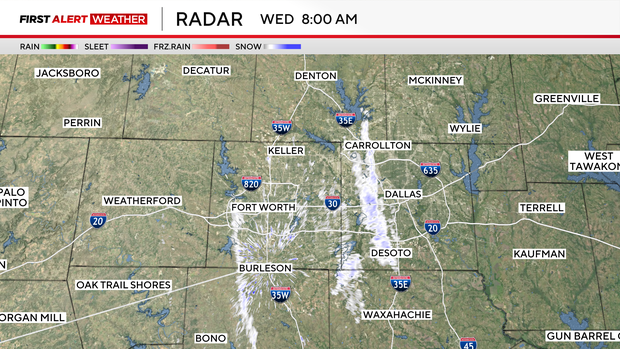
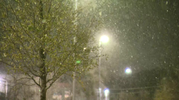
Snow falling in parts of North Texas
At around 3 a.m., snow flurries began falling in West Fort Worth, Wise County, Johnson County and parts of Parker County. Snow accumulated on grass, but isn't expected to cause any problems on the roads.
Dallas was dry for the most part, but CBS News Texas crews reported seeing large snowflakes in far North Dallas and the Irving area.
The snow falling across North Texas is dry and fine, so it won't stick on the roads, but be aware of possible black ice. Unfortunately, it isn't snowman-making snow.
What is lake effect snow?
Some of the snow is called lake effect snow, which happens when cold air moves over warm water, picking up the moisture and developing into snow.
The CBS News Texas First Alert Radar showed a band of snow developing over Lake Lewisville, dropping southeast. There were also bands of snow over Benbrook Lake and Grapevine Lake.