Dangerous cold ahead for Dallas-Fort Worth, prompting a winter weather advisory and extreme cold warning

NORTH TEXAS — It has been a cloudy, cold, and dreary day, and of course that dreariness has come with some light rain/drizzle. While accumulations haven't been major, a lot of the area is wet.
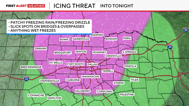
Anywhere highlighted in pink will have the chance to see some icy spots on elevated surfaces through Tuesday evening. We will likely see some lake-effect snow this evening, as well, but accumulations shouldn't impact the roads.
Significantly drier air will move in overnight, so precipitation chances come to an end by midnight, but we'll still watch for those potential slick spots into Wednesday morning.
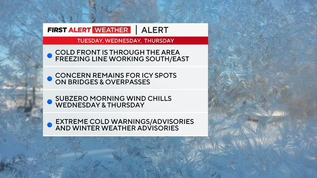
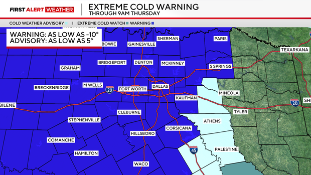
Overnight, our attention shifts from the potential icy spots to the dangerous cold. Most of the area is under an Extreme Cold Warning through 9 a.m. Thursday. This means wind chills could be as cold as ten below zero.
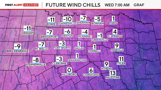
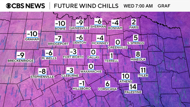
Winds will be out of the north at 15-25 mph Wednesday morning. While low temperatures will be in the teens and low 20s, the wind chills will be below zero for a lot of North Texas.
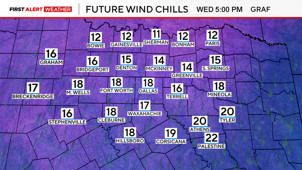
Actual temperatures will stay below freezing Wednesday afternoon, and wind chills will struggle to get above the teens.
By Thursday morning, the winds will have died down a bit. This means that while the wind chills won't be quite as cold, actual temperatures will be able to get a few degrees colder in the morning.
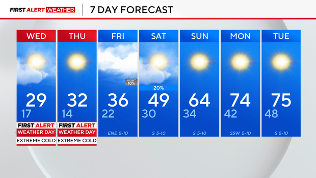
Some spots will drop below freezing this afternoon and not get above freezing until Friday afternoon. But by Sunday, calm and mild weather takes over and that should prevail through most of next week.
=====
ORIGINAL STORY
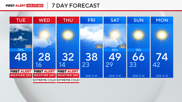
A very cold Tuesday is ahead for North Texas, with several winter weather alerts and advisories in effect. CBS News Texas meteorologists have issued First Alert Weather Days for Tuesday through Thursday.
The National Weather Service issued a winter weather advisory that will go into effect for the Dallas-Fort Worth Metroplex at 5 p.m. on Tuesday and continues until midnight Wednesday. This includes Denton, Collin, Tarrant, Dallas and Johnson counties. For counties further west, including Wise, Parker and Cooke, the advisory goes into effect at 10 a.m.
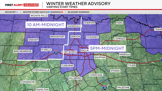
An extreme cold warning will also go into effect starting at 9 p.m. Tuesday and will continue until 9 a.m. Thursday. It includes all of North Texas. Some counties further east remain under a cold weather advisory.

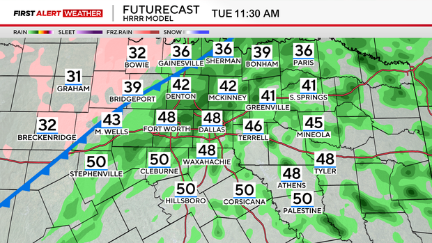
This moisture increase is ahead of the arctic front on the way to North Texas. Just after 7 a.m., the front was still northwest of North Texas but knocking on the door. The front moves through North Texas between 8 a.m. and 10 a.m. and the metroplex between 12 p.m. and 3 p.m. Tuesday.
The front is moving slightly faster so the arrival time of the frontal passage has gotten earlier. However, the sub-freezing temperatures will lag behind the frontal passage by a few hours.
The threat for ice is possible overnight Tuesday with patchy freezing rain which will create slick spots on bridges and overpasses. Don't expect a widespread icing, but anything that's wet will freeze.
At around 11 a.m., northwest parts of North Texas will start seeing freezing rain. Be cautious on bridges and overpasses.
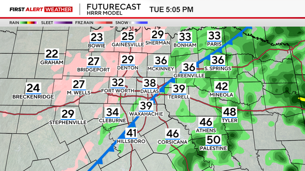
DFW won't see the freezing rain mix until 4 p.m. By 6 p.m., rain will taper off but light freezing rain is still possible. Travel impacts will be low during the Tuesday evening rush hour but not non-existent.
Wednesday will be much colder with wind chills dropping "feels-like" temperatures to -10 degrees in some parts of North Texas. Temperatures will only warm up to the teens and low 20s.
Cold weather continues on Thursday, with temperatures in the teens but feeling like single digits.
Record low temperatures are possible Thursday morning with a forecast low of 14 degrees. The record low temperature on that date is 19 degrees, set back in 1939. But Texas will be Texas and temperatures will be back into the 70s for highs starting next week.