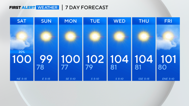
North Texas continues to see heat, temperature highs near 100
NORTH TEXAS — Saturday may have started with thunder and lightning for some viewers early this morning.

A weak cold front is moving through the area and sparked off some storms early Saturday. They brought heavy rain and gusty winds with some areas picking up a quick 1"-2" of rain.

The storms will continue to head southward leaving sunny skies in their wake as drier air moves in behind in the front. Areas south of I-20 may still get an isolated storm this afternoon along the frontal boundary. But Dallas Fort Worth is expecting sunshine and highs near 100.

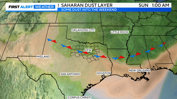
For viewers who have been bothered by the Saharan Dust in the area, the good news is that it will dissipate as we head through the weekend. Unfortunately, there is an Air Quality Alert for today for sensitive groups.
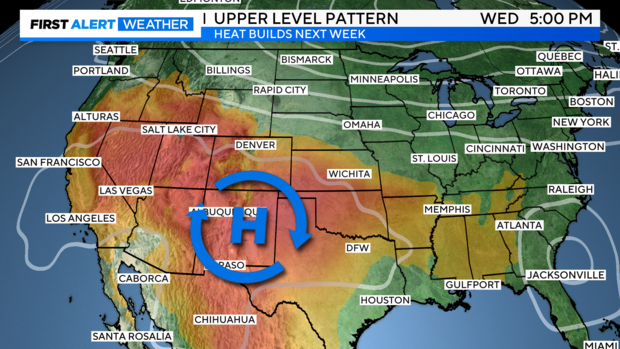
After a tiny reprieve in the heat, the heat is back in full force next week. High pressure once again shifts eastward and pushes afternoon temperatures over 100 degrees. Heat advisories will likely be needed for the middle of the week.
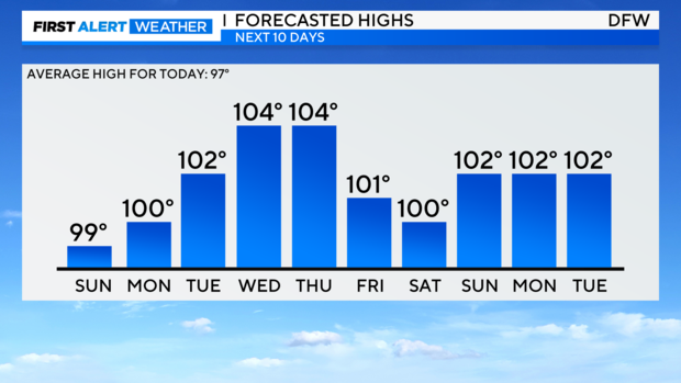
North Texas' next chance for a reprieve, arrives Friday with another weak front. An isolated shower will once again be possible with partly cloudy skies and temperatures a couple of degrees "cooler".
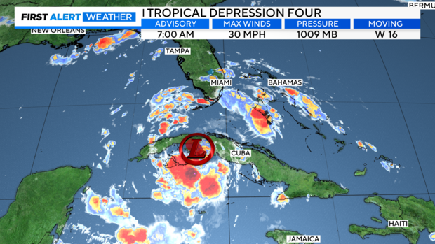
All eyes are on the southeast as Tropical Depression Four heads towards Florida. Currently, it is still disorganized as it sits over Cuba. But it will be moving out over the warm Gulf waters into an area with low wind shear, key ingredients for development. It is expected to become Tropical Storm Debby by tomorrow morning.
It may briefly become a category 1 hurricane before it makes landfall somewhere along Florida's West Coast, likely between Tampa and the Big Bend area. Georgia and the Carolinas are also looking at impacts, including heavy rain and strong winds.
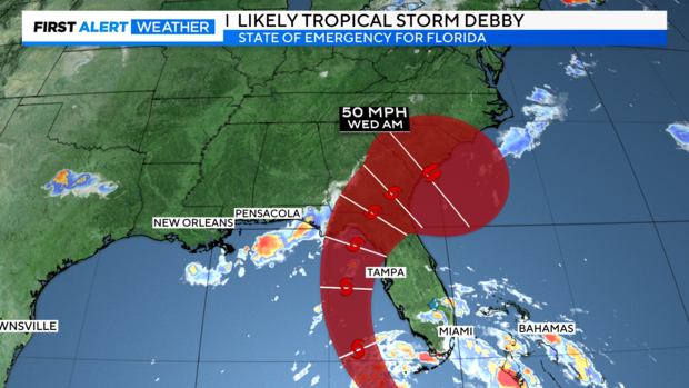
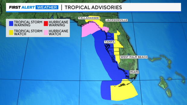
Tropical Storm Warnings and even Hurricane Watches are in effect for Florida's West coast. Storm Surge watches are also in place for surge 2' – 5' , especially in the Big Bend as onshore flow stacks water up along the coastline.
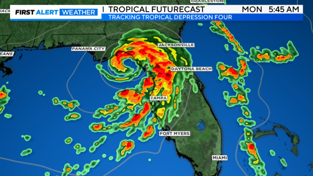
First Alert Futurecast shows the system organizing in the Gulf bringing tropical downpours to the Peninsula today through Monday.
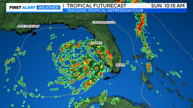
The system will likely continue to organize and strengthen as it nears Florida's coastline Monday morning.
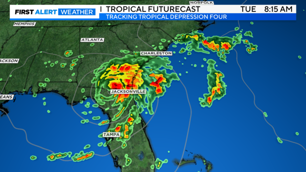
It will track inland Monday into Tuesday bringing flooding rain to parts of Georgia and the Carolinas.
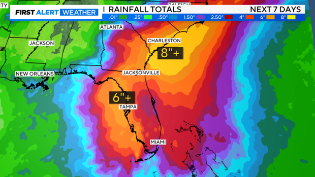
Parts of Florida could see 6"-10" of rain with even higher amounts possible near Charleston.
Advise any friends or family in the path of Tropical Depression Four to make sure they stay up to date with the latest forecasts.