DFW Weather: Temperatures In 90s Monday, Storm Chances In Evening
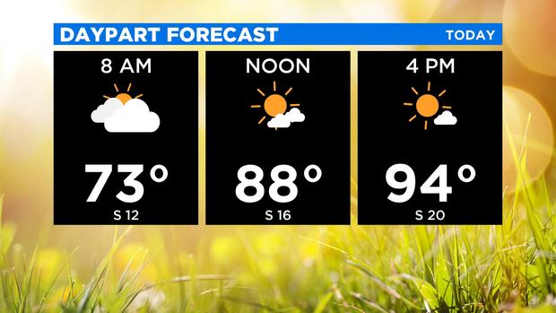
(CBSDFW.COM) - After a hot and humid weekend of weather, we'll see our warmest day of the stretch this Monday with highs climbing into the low to mid-90s.
A very warm air mass continues to build ahead of our next cold front which is set to arrive overnight and into the pre-dawn hours Tuesday.
While today will be 10 to 15 degrees above average, it's not the hottest day of 2020. Back on April 8, we hit 97 from DFW Airport.
Cooler air that's more seasonable is on the way thanks to tonight's cold front, but first, we have to dodge the threat for a few strong storms.
The more widespread severe threat tonight lies up in Oklahoma but these storms are expected to drift south into North Texas by late evening and diminish into the overnight.
We'll especially need to pay attentions to these storms as they eye our Red River counties from 8 p.m. to 11 p.m.
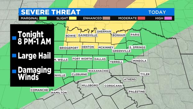
Storms that arrive could hold together long enough to impact the DFW Metroplex anytime from 10 p.m. to 1 a.m. Main threats would be large hail and damaging winds.
As the cold front drifts by Tuesday morning, some occasional light rain is possible with cooler temperatures as highs struggle to reach 80 degrees.