Live Storm Reports From Mobile 11
8:30am
We've been cleared from the last hit, Jake Shannon and I heading back to recharge all the devices. Glad there was no severer weather with this round but you can see how we'll cover any threat during the morning. We'll SHOW you what its doing with Mobile 11 as we track and follow the storms. Its how we roll.
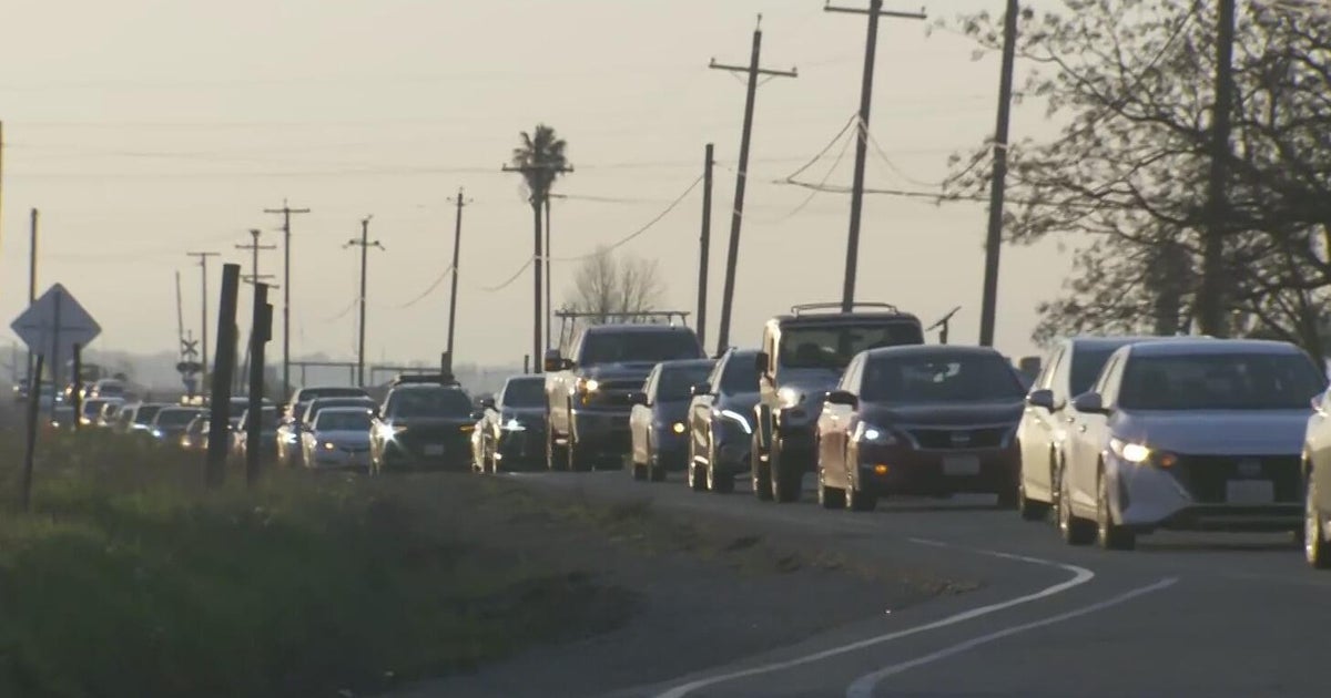
Whitney Drolen will update you on all the traffic woes this heavy rain caused; coming over the metro area at the height of the morning commute. Tomorrow morning's commute? DRY! Jeff Ray signing off.
8:20am
No surprise here; its a slow roll along I-30 this morning in the Arlington area. When is it not? Light rain. The storms would be clear of DFW when CNN wanted to take us live so its cancelled. Dang, chance to go nation-wide always exciting.
8:07am
Heading right by station right now, left New Salem with the storm around 6:35am. Still in the moderate rain. 8" of snow expected in Kansas City today/tonight. Right now its 20 degrees there with light snow and freezing fog, gusts at 26mph. Nice.
7:56am
Taking us live for the upcoming cut-in on CBS11. On I-30 heading east just by Hulen stree in Fort Worth. Steady rain, moderate in nature. No lightning or wind. Just making for a slow commute. Second morning in a row of it.
7:40am
We caught back up to the heavy rain just past the I20-I-30 split. Hit the traffic as well here on the western edge of Fort Worth just before I-820.
7:27am
Garry Seith just took our Mobile 11 shot live during the cut in. We were just east of Weatherford in Parker County heading east. We are just behind the heavy rain, can see the leading edge of storms in the clouds ahead now there is some daylight.
7:20am
Nothing to the tree damage; somebody was doing some trimming yesterday and still had trees on side. Jake and I were suspect from the start; report came in a good 10 minutes before storm line hit! Anyway, we are in Weatherford getting gas. Will go live at 7:25am. Just told we'll be live on CNN at 10am. Hope the storms are still in our area by then...
7:05am
Heading to a report in Weatherford of some trees down. Big fat cell has caught up with us again, some ground strikes and, of course, a heavy, wind-driven rain.
6:50am
We are currently just ahead of the heavy rain as we close in on Weatherford. Looking like a very small hail core will be meeting us there, coming up inside the line from the southwest. Likely no hail making it to ground. This will be a heavy rain from the Fort Worth/Dallas area during the next hour.
6:40am
Yea! Just as we went live the leading edge of the storm hit Jake and I. Wind gusted close to 40mph just as we tossed back to Garry. We are now heading east on I-20 riding in on the storm. Nothing severe but heavy rain and brief strong winds just as the rain starts. Frequent lighting.
6:25am
Will be live standing out in the incoming storm here at 6:30. Then Jake and I will follow the line into the metro area. You can see the Mobile 11 shot in several spots during the last 30 minutes of the Morning Show.
6:20am
Garry just showed you the radar. Heavy rain closing on Jacksoboro and in the northwest corner Wise county. Storms edge 6 miles from us. Starting to get some of the rain blowing off the top of the storm.
6:17am
Starting to see lightning from our location. Radar indicates small hail cores aloft in the cell over Gordon heading toward Mineral Wells and Milsap. Another cell of similar strength just west of Bridgeport in Wise County. Nothing severe.
6:14am
Heavy rain with pea-size hail over Strawn, also up across Montague County from Bowie and north. Lightning just to our west, main line of storms 15 miles from us and closing. Winds are briefly calmed.
6:10am
Cells are formed over Ellis County, strongest cell just NE of Waxahachie headed to Balch Springs. Line we are waiting for stretches from Goldthwaite up to Nocona and into Oklahoma. We'll be in the thick of it around 6:30 or so. Low ceiling, mist and light fog as the storms approach.
5:57am
We are in Palo Pinto County at 281 exit near New Salem. The strongest cells Garry is showing on radar are to our northwest moving into Young and Stephens Counties. The cells that will hit us are almost to Ranger headed across eastern Eastland County, a little less than 30 miles from us right now.
5:25am
Cells are at Eastland County line moving east at 35mph. Small hail, frequent lightning, heavy rain associated with these cells. Be on top of us around 6am I'm guessing.
5:20am
Just getting some big rain drops, probably blow off from the bigger cells to our west. Most of the time it's just drizzle.
5:15am
We are going to have to stop right at the Palo Pinto County line; this is the comfortable edge of our broadcast range in HighDef. The cell heading up I-20 is over Putnam headed toward Cisco and Eastland. We are just south of Santo.
5:00am
Just went live. Past Weatherford now on I-20 heading toward the storms. Low ceiling and light mist at 42 degrees. Line of storms moving toward us at 35mph, we are moving toward that line at highway speeds. Watching a strong cell on the western edge of Young County just south of Albany, probably some small hail. Up in Young County we can see a cell at the western county line heading toward Olney.
4:52am
Beaufort scale review: Force 7 gets your attention,Force 8 is the start of trouble. Moderate Gale: whole trees sway (7). You start seeing twigs in the air? Winds at 40mph. When branches start to break you are getting close to shingles coming off: Force 9 high end is 54mph, the threshold of severe.
4:45am
Jake Shannon at the wheel in CBS11 Mobile 11 unit, me in the storm spotter seat. We are pushing west fast, heading toward a squall line just at the western edge of our viewing area. That line is headed toward us at 35mph and should enter the metro area betwen 7am and 8am. Strong cells entering Young and Stephens county. We checked in live with Garry Seith in the CBS11 Storm Center at 4:30, will check back in at 5am. Currently its 44 degrees with wet roads.