A Full Slate Of Weather To Watch In North Texas This Week
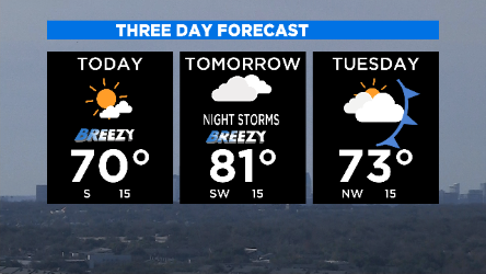
NORTH TEXAS (CBSDFW.COM) - In your typical North Texas tradition, we'll have different weather each day of the coming week. For the rest of today and tomorrow, strong south winds and bone-dry conditions are increasing the grassfire threat for the western half of the our coverage map, including most of the Metroplex.

Warm and windy next couple of days, highs hit the low 80s tomorrow. Temperatures will fall quickly at the end of the day on Tuesday.
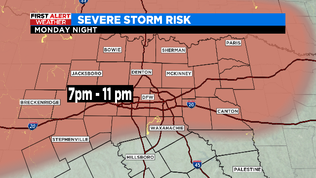
SEVERE WEATHER RISK MONDAY NIGHT
The cap (a layer of warmer air just off the surface) will limit storm development on Monday for most of us. We'll have to watch the rain in our eastern counties across the afternoon in case a storm or two breaks through the cap. By nighttime the atmosphere will cool through all the layers enough to allow for storm development. The favored area for severe storms will be along I-20 and north, including the Metroplex. Hail up to 1" and damaging winds are the main threat.
WARDROBE CHANGE AHEAD
Tuesday afternoon we watch the temperatures drop as a strong arctic front moves in, strong north winds push the temperatures down to freezing by Wednesday morning on very strong winds (N 20-30mph)
WINTER NOT DONE WITH US
Problems start on Wednesday morning. Sleet/rain mix will pelt the Metroplex on Wednesday, getting worse as we get into afternoon. Since highs are forecast to stay (just) above freezing all day I'm not expecting travel problems through the day. However, conditions could be MUCH worse in our northwest counties from Young over to Cooke. It'll be colder there with a mix of freezing rain/sleet falling much of the day.

If the Metroplex has ANY bridge/overpass issues it would be by Thursday morning as temperatures drop to just around freezing. A second wave of sleet/freezing rain greets us on Thursday morning. Again, most of roads around the Metroplex will have suffer sleet/rain, changing over to a cold rain by afternoon. The same areas where we are expecting accumulating ice will be hit the hardest the second time as well:

BLACK ICE THREAT FRIDAY MORNING
Lows are expected to drop down into the low 20s by Friday morning. Any water/sleet on the roadways or bridges will freeze overnight, some slick spots are possible across the Metroplex that morning. Highs that day get in the mid-40s which will melt away any concern.
THIS IS JUST THE LATEST THINKING
Small changes in the depth of the cold air, how far south the freezing line gets, and how long the frozen precipitation carries into the overnight Thursday could change this forecast significantly. Stay tuned, there is lots of weather to watch out for this week.