Heavy rain, storms and flooding hit North Texas after months of hot, dry weather
The CBS News Texas First Alert meteorologists are tracking another round of rain moving across North Texas on Friday, following heavy rain and flooding across the region on Thursday.
Much of the DFW Metroplex has received more than 4 inches of rain, which led to a flooding threat after months of above-average temperatures and virtually no rainfall across the region.
The storm comes from the remnants of former Hurricane Polo as the storm crossed Mexico and entered the southwestern U.S. Millions of people from Arizona to Iowa have been at risk for flash floods.
Thursday's rainfall totals
Rainfall totals in the DFW area ranged from just under 3 inches to nearly 6 inches on Thursday.
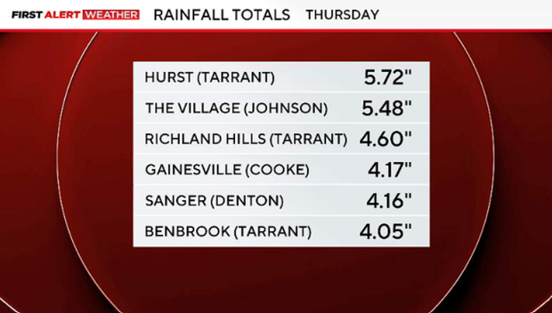
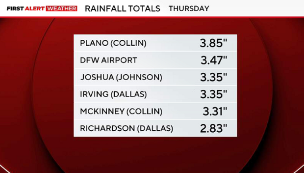
Thursday was also the ninth-wettest day ever in the month of October for DFW. The region received more rain on Thursday than it did in all of July, AUgust and September combined.
Heavy rains cause sanitary sewer overflows in Fort Worth
The City of Fort Worth has told state regulators that two sanitary sewers went into overflow as a result of the heavy rains.
One is located in the 7000 block of Enterprise Avenue just west of Handley Ederville Road. The city estimates 1,000 gallons a minute of sanitary sewage was being released.
The other location is in Greenway Park, where an estimated 300 gallons per minute are being released.
Fort Worth will conduct site cleaning and disinfection efforts at both locations, a spokesperson says.
Flight cancellations, delays at DFW International and Dallas Love Field airports
Flight cancellations and delays are being tallied Thursday morning as waves of heavy rain and storms begin to enter the area.
As of 2 p.m., Dallas-Fort Worth International Airport has reported 1,132 delays and 324 cancellations. And Dallas Love Field Airport has reported 239 delays and 36 cancellations.
State Fair of Texas delays opening due to flash flooding
State Fair of Texas officials have announced that the fairgrounds will open a few hours later due to heavy rain and storms moving across Dallas on Thursday morning.
Officials said the gates will open at noon.
"The safety of our fairgoers, vendors, partners, and team members remains our top priority. Please use caution when traveling to Fair Park and continue to monitor our social channels and local weather alerts for any additional updates," officials said in a social media post.
Thousands without power across North Texas as heavy rain, storms continue
Thousands of customers are without power Thursday morning as heavy rain and storms sweep through North Texas.
According to the Oncor outage map, as of 8:30 a.m., over 8,600 people are without power in Tarrant County – the most reported so far. About 700 customers are without power in Dallas County, over 500 are without power in Denton County and over 1,200 are without power in Johnson County.
In total, Oncor has over 15,000 customers without power Thursday.
If you're experiencing a power outage, you can report it here.
Flash flood warning issued for Dallas, Denton and Tarrant counties
A flash flood warning has been issued for Dallas, Denton and Tarrant counties on Thursday morning as heavy rain continues to move through the area.
The warning for all three counties is in effect until 10:30 a.m.
The locations experiencing significant flash flooding include: Arlington, Bedford, Carrollton, Coppell, Denton, Euless, Grand Prairie, Haltom City, Hurst, Flower Mound, Frisco, Fort Worth, Irving, Keller, Lewisville and Mansfield.
Flood watch extended through Friday for North Texas
The National Weather Service of Fort Worth confirmed the flood watch issued for much of North and Central Texas has been extended through Friday morning as slow-moving storms are expected to bring heavy waves of rain and flash flooding to the areas.
A few strong to possibly severe storms are possible along and west of the I-35 corridor Thursday afternoon into the night.
The flash flood warnings for Cooke and Montague counties have also been extended until 7 a.m. Thursday.
Several events canceled, postponed due to flooding threat
Several events have been canceled or postponed due to the threat of flash flooding throughout North Texas to finish out this week.
The Lewisville High School Farmerettes' trunk-or-treat event has been postponed. It was planned for Thursday night. A new date has not yet been announced.
Harmony School of Fort Worth also postponed its honors induction night. That event was scheduled for Wednesday night, and school officials say a new date will be announced soon.
Universal Kids Resort in Frisco will be closed on Thursday. The resort hotel will remain open.
And all events on the Klyde Warren Park calendar have been canceled through Saturday.
The state fair of Texas remains open rain or shine — but officials say rides, attractions, shows, and other activities may be delayed, closed or canceled because of weather.
DeNeeka Hill contributed to this report.
Strong thunderstorms moving in North Texas
Strong thunderstorms will impact portions of northeastern Eastland, eastern Stephens and western Palo Pinto counties through 3:30 a.m. Wind gusts up to 50 mph can be expected.
The National Weather Service said at 2:58 a.m., Doppler radar was tracking strong thunderstorms along a line extending from near Caddo to near Lake Olden. Movement was northeast at 40 mph.
Flood advisory is issued for Young, Stephens, Jack, Palo Pinto counties
A flood advisory is issued for Young, Stephens, Jack and Palo Pinto counties until 6 a.m. due to the ongoing heavy rain.
The National Weather Service said just before 3 a.m. that up to 1 to 3 inches likely fell in the previous hour and another 1 to 3 inches are possible. NWS said some of that was over the Ross Fire burn scar.
Strong thunderstorms head for Montague, Cooke counties
Strong thunderstorms will impact portions of Montague and western Cooke counties through 3 a.m. Winds over 40 mph can be expected.
At 2:05 a.m., Doppler radar tracked strong thunderstorms moving 35 mph east along a line extending from Ringling to Lake Amon G Carter.
Flash flood warning issued for Montague, Cooke counties
A flash flood warning has been issued for Montague and northwestern Cooke counties until 5 a.m.
Radar estimates that between 1 and 4 inches of rain have fallen in the past few hours. Additional rainfall amounts of 1 to 3 inches are possible, according to the National Weather Service.
Flood advisory issued for Cooke County
The National Weather Service has issued a flood advisory until 2 a.m. for northwestern parts of Cooke County. Just before 11:30 p.m., radar indicated anywhere between one and three inches of rain have fallen in the past hour in that area. Minor flooding of roads and low-lying areas is likely, forecasters said.
Strong thunderstorm brings damaging winds to North Texas
A strong thunderstorm will impact portions of southwestern Montague, northwestern Wise and northeastern Jack counties through 11:30 p.m. Winds of at least 40 mph are expected.
The National Weather Service said radar estimates parts of southwest Montague County, including Bowie, have received nearly 3 inches of rain, which oculd cause street flooding in some areas.
Flood advisory issued in North Texas
A flood advisory is in effect until 1 a.m. Thursday for Jack, Montague, northwestern Wise and northeastern Young counties.
A strong thunderstorm will impact portions of southeastern Montague County through 10:45 p.m.
Storm arrival times for the Dallas-Fort Worth area
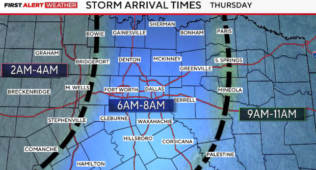
Thursday morning remains our highest-impact window, and the latest timing places the main line directly into the morning commute across DFW.
Flooding and strong winds will be the primary concerns, with a low tornado threat as well.
Based on the latest guidance, Friday continues to look considerably lower impact, with mainly scattered showers expected rather than another widespread heavy-rain event. I'll continue to update if that changes overnight.
DFW storms could bring flooding, damaging winds overnight
The storms west of DFW should slowly move east-northeast through Wednesday evening with no sign of weakening.
The main threats Wednesday night will be training storms that could lead to flooding, strong to marginally severe winds and hail.
We're also watching the cluster of storms moving north along the I-35 corridor in Central Texas and the cluster in East Texas.
The storms in East Texas are moving into more stable air to the east and should gradually weaken the further east they move.
The evolution of the showers/storms in Central Texas and south of DFW near Hillsboro is more uncertain. They should last a few more hours and weaken a bit after sunset.
The timing of the main line is now expected to move into our far western counties around 2-3 a.m., approach the I-35 corridor in North Texas around 6-7 a.m., and our northeast counties around 10-11 a.m.
It should move across North Texas more quickly than it did through Central Texas, so expect it to enter the I-35 corridor in Central Texas around 8-9 a.m. How it evolves on Thursday is uncertain.
The main threats as it moves into our area late Wednesday night/early Thursday morning are strong-to-damaging wind gusts, a low threat of spin-up tornadoes and flooding.
Fort Worth sandbag giveaway ends early
Fort Worth invited residents worried about potential flooding to come pick up free sandbags on Wednesday at two locations. The giveaway was supposed to run from 8 a.m. to 5:30 p.m, with up to 15 sandbags available on a first-come-first-served basis.
At about 9:30 a.m., the city said that distribution at both locations had ended for the day. On Wednesday afternoon, a spokesperson for the city's Transportation and Public Works Department said in a statement that they had 750 sandbags to distribute at each location.
"Due to exceptional community turnout, the City of Fort Worth has successfully distributed far more sandbags than originally planned—500 were distributed per location just within the first hour," the statement said.
The city is encouraging residents to check the status of flood warning flashers and sign up for emergency alerts ahead of the storm.
Dallas Fire-Rescue preparations
Dallas Fire-Rescue is preparing to respond to potential flooding. Station 59 is one of the department's main stations responding to swift-water calls.
"The northwest part of town is one of the notorious ones, East Dallas, Old East Dallas, downtown, any of those," said Captain Timothy Baker. "The Turtle Creek area, obviously, we've had some notorious runs out there."
Baker said crews train year-round and keep a close eye on flood-prone areas, including the Trinity River floodplain, which is susceptible to runoff-driven flooding. During heavy rain, DFR tends to see several calls for people who drive into high water, as well as flooding at homeless encampments.
Flood-prone areas in North Texas
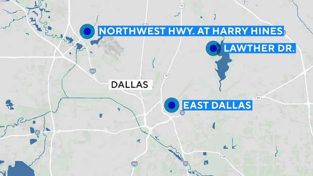
With the heavy rain on the way, here are some areas of North Texas that have flooded in past storms, which drivers may want to avoid on Thursday morning:
Dallas
- Northwest Highway near Harry Hines Boulevard
- Lawther Drive on the northwest corner of White Rock Lake
- East Dallas near Baylor University Medical Center
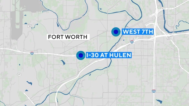
Fort Worth
- I-30 and Hulen Street
- West 7th Street entertainment district
Homecoming parade canceled
Lovejoy ISD in Collin County canceled its homecoming parade that was scheduled for Wednesday evening in the Heritage Ranch neighborhood in Fairview.
"We know how much our students, families, staff, and community look forward to this special Lovejoy tradition, and we share in the disappointment. However, the safety of our Lovejoy community must always come first," the district said in a social media post.
The district is working to reschedule to parade.