Weekend Rain Not Expected To Cause Debris Flows In Fire Burn Areas
SONOMA COUNTY (CBS SF) -- Cool and rainy weather this weekend is not expected to cause debris flows and erosion in the wildfire burn areas of Sonoma and Napa counties, according to the National Weather Service.
"The latest trend is it looks drier than forecasted earlier in the week. There will still be rain, but not enough to cause debris flows. We don't anticipate widespread problems," forecaster Ryan Walbrun said.
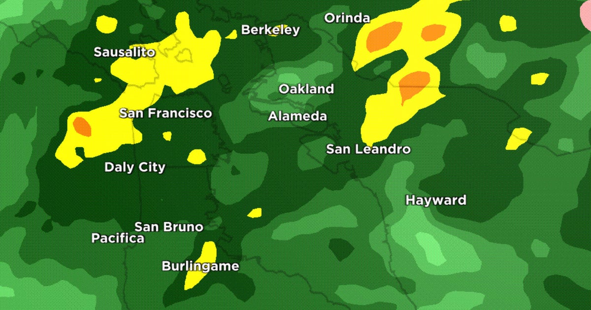
Showers dropping down from the north should begin in the North Bay after midnight and continue off and on Friday. There may be moderate rain in Sonoma and Napa counties overnight Friday and Saturday morning. Rainfall should be between a quarter- and half-inch, Walbrun said.
The North Bay will clear Saturday but another cold front bringing rain will arrive Sunday night into Monday morning. Rain is possible Wednesday and next weekend, Walbrun said.
Officials in Sonoma and Napa counties were concerned earlier this week about heavy rain washing toxic debris from burned residential areas into streams and creeks and causing erosion and pollution in rural areas.
Napa County officials said much of the rain will soak into the ground and large flows of ash and debris are not expected.
The county is actively preparing for future storms as winter months approach, county spokeswoman Kristi Jourdan said.
Work crews are removing dead and dangerous trees, clearing drainage areas and debris along roadways and replacing road signs, guardrails and retaining walls.
Napa County provides free sandbags to control sediment and erosion on properties. A list of sandbag locations is available at www.countyofnapa.org.
Meanwhile, the approaching cold front is expected to dump nearly 3 feet of snow on the ski resorts around Lake Tahoe.
The National Weather Service has issued a winter storm watch for the Lake Tahoe area from 5 p.m. Friday until 4 a.m. Sunday morning.
The forecast has skiers abuzz with anticipation of the approaching front. Forecasters said 12-18 inches of snow was possible about 6,000 feet south of Highway 50.
At the higher elevations, the weather service said, 1-3 feet was very possible.
Gusty winds were also predicted for the mountain passes where chains could be required of travelers for the first time this fall.
National park officials say a mountain pass across the Sierra Nevada that runs through Yosemite National Park is closing to traffic ahead of the storm.
The National Park Service says Tioga Road, the soaring eastern entry to the park, will close to vehicular traffic at 5 p.m. Thursday.
Officials will also close Glacier Point Road, which offers sweeping views of Yosemite Valley.
They say both roads will be closed through Monday, when the storms are expected to dissipate and road conditions can be assessed.
The Bay Area also will be impacted by two storm fronts from Friday through Sunday.
Light precipitation was expected to develop late Thursday night into Friday morning over the North Bay and along the coastal ranges. Rain would become a bit more widespread Friday night into Saturday as a cold front approaches.
The weather service told residents to expect a brief break in precipitation late Saturday into Sunday morning.
Another frontal boundary through will then roll through late Sunday into Monday morning, bringing another round of showers to the Bay Area.
Amounts of 0.25 of an inch to nearly an inch were forecast near the coast and in the lower elevations with potentially much lower amounts in the rain shadowed valleys.
TM and © Copyright 2017 CBS Radio Inc. and its relevant subsidiaries. CBS RADIO and EYE Logo TM and Copyright 2017 CBS Broadcasting Inc. Used under license. All Rights Reserved. This material may not be published, broadcast, rewritten, or redistributed. Bay City News Service contributed to this report.
