Thick layer of Tule fog triggers Bay Area travel advisory
FAIRFIELD -- A thick blanket of tule fog crept into the eastern edges of the San Francisco Bay area for third morning Monday, triggering an advisory from the National Weather Service.
The advisory for areas around San Pablo Bay, Suisun Bay, the West Delta and the San Francisco Bay north of the Bay Bridge until the heat of the day burns the fog off around 11 a.m.
"Dense fog affecting the North Bay and East Bay interior valleys this morning reducing visibility to 1/4 mile or less at times," weather service forecasters said. "This is a result of Tule fog over the Central Valley being advected eastward toward the Bay Area."
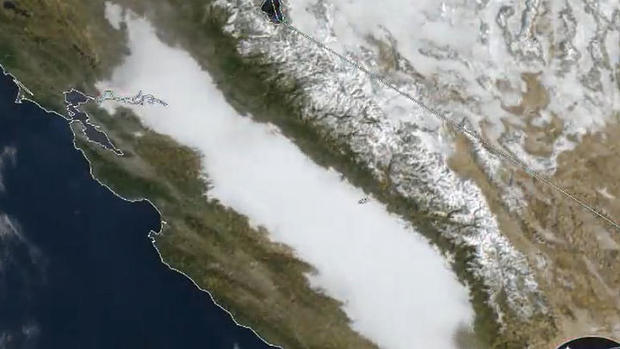
Tule fog is formed by a combination of high humidity, calm winds and frigid overnight temperatures. Each winter it blankets the Central Valley along I-5 from Redding to Bakersfield in the wake of cold weather storm systems.
It's particularly dangerous because how quickly it can form. One minute the road in front of you is clear, minutes later your vehicle could be enveloped in dense fog.
On Monday, the blanket of fog in the Central Valley was easy to see on West Coast satellite photos.
In the wake of last week's rain showers, a mass of cold air has parked over the Bay Area, triggering frigid temperatures.
The weather service said San Francisco's average high temperature between Nov 1-Dec 17 is the eighth coolest on record and the coolest since 51 degree reading in 1994. It has also led temperatures dipping into the 20s in some areas in the early morning hours.
The chilly early morning temperatures and wet conditions give rise to the fog locally.