Shady Fire Update: Deputies Rescue Trapped Residents; Massive Ember Cloud Ignites Oakmont Home Fires As Thousands Flee
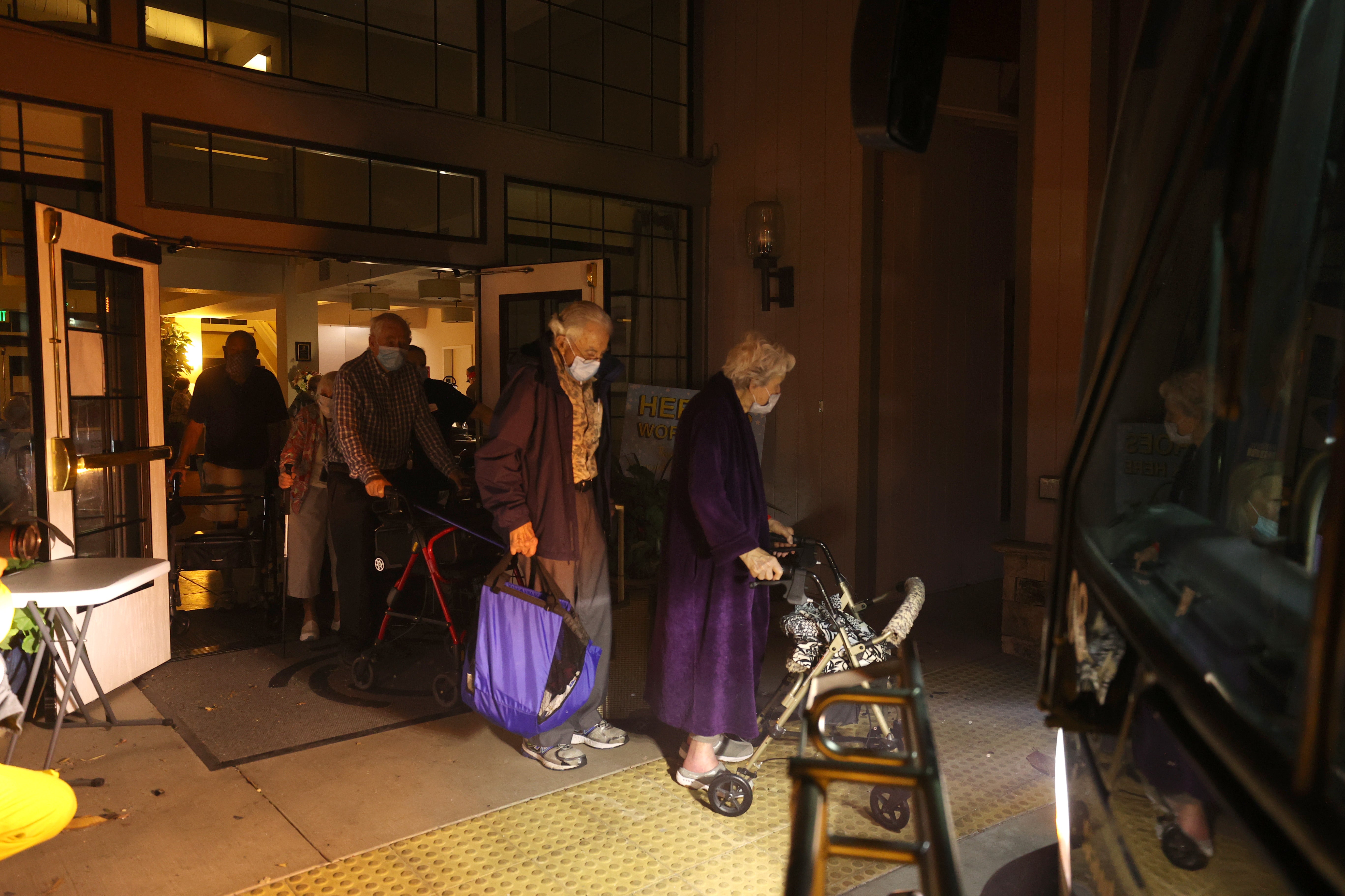
SANTA ROSA (CBS SF) -- Santa Rosa city buses raced into the Oakmont Village retirement community early Monday, frantically loading up elderly residents for a dash to safety as a flames and a massive cloud of embers from the Shady Fire advanced into Sonoma County and consumed homes in the Sky Hawk and Oakmont neighborhoods.
During a Monday news conference, Sonoma County Sheriff's Sgt. Juan Valencia said deputies were forced to stage rescues during the early morning hours on Los Alamos Road after residents initially refused to evacuate.
EVACUATION MAPS: Sonoma County | Napa County
"We want to remind people when you get the Nixel (alert) and you hear that high low siren and you get the knock on the door, deputies or law enforcement officers telling you its time to leave -- it's time to leave," he said during a Zoom news conference. "Unfortunately, we did have some people that stayed behind and might have been burned in some areas."
Evacuation Order Information:
- Napa County Evacuation Order Information
- City of Calistoga Evacuation Information
- Sonoma County Evacuation Information
- City of Santa Rosa Evacuation Information
"It's better that they leave that way we can sit there and do our jobs and not have to go back and rescue people which deputies had to do last," he added. "They were going back up to Los Alamos Road after people were refusing to leave and rescuing people out of their homes."
Elsewhere, residents of the Oakmont Gardens retirement community lined up to board the buses early Monday, many in wheelchairs, using walkers and carrying what few belongings they could. Nearby, the threatening orange glow of the advancing flames lit up the light sky. The buses drove through clouds of embers as they escaped to an evacuation center at the Santa Rosa Veteran Auditorium.
ALSO READ: Glass Fire Update: Napa And Sonoma County Road Closures Due To Wildfires
But by 3:11 a.m., the elderly residents were on the move again as officials -- "out of an abundance of caution" -- the Veterans building and the Santa Rosa Fairgrounds were closing as shelters and evacuees were moved to the safer confines of Petaluma.


A cloud of hot embers was being blamed for homes fires throughout the Oakmont neighborhood.
The Red Flag winds were an issue all night long.
"Overnight winds in the North Bay ranged 35-55 mph in locations over 1000 feet, with some isolated pockets measuring 60 mph gusts," the National Weather Service said. "A station in the Healdsburg Hills (2480 ft) near the Mayacmas Mountains in far northern Sonoma County reported a max wind gust of 67 mph. In Santa Rosa, winds gusted to 30 mph as the fires were quickly fanned towards the southwest."
PHOTOS: Raging Glass Fire Leaves Path Of Destruction Through Wine County
Thousands of residents desperately trying to escape to the flames also clogged Highway 12 early Monday morning with bumper-to-bumper traffic.
Meanwhile, Sonoma County Sheriff's deputies and Santa Rosa police officers raced door-to-door through threatened neighborhoods under evacuations orders to make sure they had fled. By early Monday, more than 10,000 residents had been forced from more than 6,500 homes.
Scenes that have become all to familiar to wine country residents unfolded in the Mountain Hawk neighborhood early Monday as entire blocks of homes erupted into flames triggered by the massive cloud of glowing embers. Firefighters battled the flames, but the advancing wall of fire proved to be too powerful.
The Shady Fire was one of three wildfires that erupted in the region on Sunday. On Monday, Cal Fire merged the Shady Fire with the Glass Fire, which was burning homes and wineries near St. Helena, and the smaller Boysen Fire. The total acreage for all three stood at 11,000 acres.
Red Flag Warning conditions set the scene for a flare-up in activity in the early morning hours with sweltering temperatures and dry, gusty offshore winds blowing through the area. The warning remained in effect until 9 p.m. Monday.
The Glass Fire had grown to over 2,000 acres by early Monday and was approaching Petaluma while the Boysen Fire was burning west of Petaluma.
"The winds have definitely picked up overnight," Santa Rosa Assistant Fire Chief Paul Lowenthal told KPIX 5. "They are strong, gusty, erratic winds. The fire has come over the hills into the Sky Hawk and Oakmont areas. It's on both sides of Highway 12 to the east of Skyhawk."
"The evacuation orders that we had in effect for east of Calistoga Road, went into effect for a reason," he added. "We saw the fire coming in this direction. Using the tools and system we have in place to make sure they were able to get notifications out as quickly as possible...We evacuated 6,500 homes as quickly as possible."
The smoke, flames, blowing embers and frantic evacuation recalled memories of many Santa Rosa residents of the 2017 Tubbs Fire. The October blaze burned 36,810 acres, destroyed entire neighborhoods and claimed at least 22 lives in Sonoma County.
Officials advised evacuees not to use Petrified Forest Road to evacuate. Highway 29 is open to Lake County. Highway 128 was open to Sonoma County.
Santa Rosa Police issued evacuation orders for the areas of Calistoga North, Calistoga South/Skyhawk, Oakmont North, Oakmont South, Melita, Stonebridge and Pythian. Residents were told to leave the area immediately and head south.
Evacuation warnings were issued for the areas of Summerfield, Spring Lake, Northeast 2 and Northeast/Middle Rincon shortly before midnight.
By Monday morning, Santa Rosa officials had issued evacuation orders for:
Evacuation for the entire area of Northeast 2:
- East of Brush Creek Rd
- North of Montecito Blvd
- West of Calistoga Rd
- South of City Boundary (north of Badger Rd area)
The entire area of Northeast 3/Middle Rincon:
- East of Mission Blvd
- North of Highway 12
- South of Montecito Blvd
- West of Calistoga Rd
The entire area of Summerfield:
- East of Summerfield Rd
- South of Stonehedge Dr
- North of the City boundary
- West of the City's boundary (Annadel State Park)
The entire area of Spring Lake:
- North of Stonehedge Ave
- West of Violetti Rd (East side of Spring Lake)
- South of Highway 12 (Between Mission Blvd and Calistoga Rd)
- South of Montgomery Rd (between south end of Calistoga Rd to Channel Dr)
More detailed information on the evacuation orders can be found on the Santa Rosa Police Nixel alert page.
Sonoma Raceway has also opened its 50-acre campground to evacuees seeking temporary refuge from the fires.
The raceway, which is equipped to handle up to 2,000 campers during its major event weekends, is available for tent and RV campers in need of temporary shelter.
The campground is located directly across from the raceway on Highway 121 and has not been affected by the fires. The raceway will follow COVID-19 safety protocols during evacuation shelter procedures, including mandatory face coverings and social distancing. Evacuees seeking RV or tent camping at Sonoma Raceway should enter the campground at Gate 6 on Highway 121, a quarter-mile north of Hwy 37.


