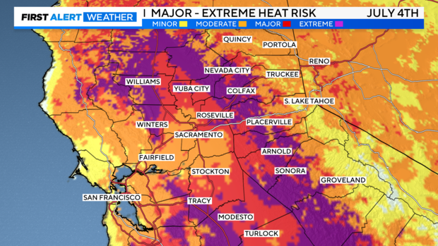
Extreme to major heat risk possible across Northern California during holiday heat wave

After a warm weekend, July will be off to an even hotter start. A long-duration heat wave begins on Monday with valley highs soaring above 100 degrees through the upcoming weekend. Major to extreme heat risk is expected.
These will be the hottest temperatures we've seen not only this year but since 2022 for most of Northern California.
The hot pattern in place
As of Sunday, a ridge of high pressure has begun to build west of the California coast. The ridge will continue to expand eastward and strengthen through the week, increasing afternoon highs and locking in excessive heat through the workweek.
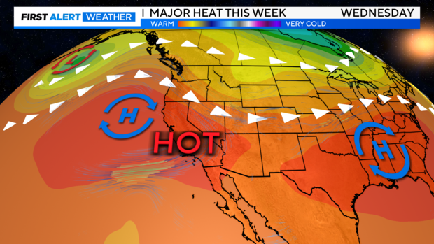
The placement of the ridge will be important to when temperatures peak and when they scale back. The closer the ridge of high pressure is to California, the greater the chances of five-plus days of high temperatures between 100-110 degrees.
As of Sunday, models are keeping the strong ridge in place through next Saturday, July 6, keeping the Fourth of July holiday and the holiday weekend very hot.
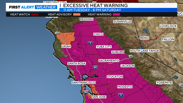
An Excessive Heat Warning has been issued from Monday to Saturday.
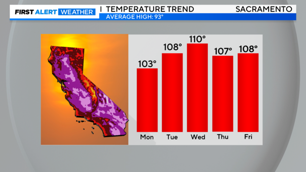
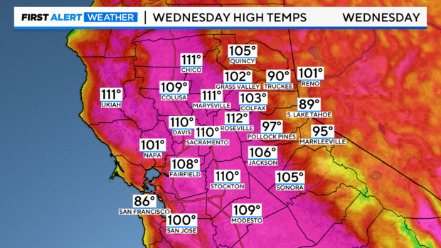
Some areas may match or break daily records. Temperatures will be just shy of records in Sacramento for July.
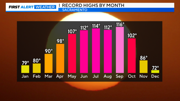
Be cautious trusting your weather app this week as many apps have issues with valley heat waves. If numbers seem too extreme, they probably are. Anything above 110 degrees is not likely in Sacramento this week. The hottest day ever recorded in Sacramento was 116 degrees on September 6th, 2022.
The hottest day this week is expected to be on Wednesday, July, 3 with many in the valley reaching 110 degrees or more.
Afternoons will be very hot and during the evenings there will be little overnight relief. Heat-related illnesses will be possible.
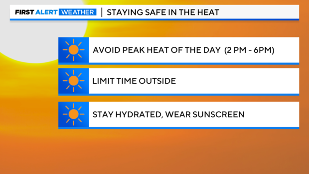
It's important to have a plan in place if your power turns off. Try to limit your time outdoors during the peak heat of the day and stay hydrated.
Critical fire danger begins Monday
Along with the boost in temperatures, fire danger is about to increase as we start the week.
A Red Flag Warning has been issued for the Sacramento Valley, portions of the San Joaquin Valley, and Delta starting on Monday night through Wednesday evening as fire weather conditions increase.
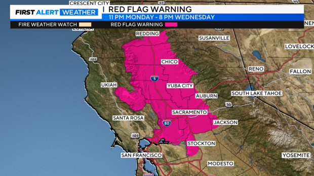
Northerly winds pick up on Monday and gusts up to 30 mph will be possible through Wednesday. Humidity during this time will also be very low ranging from 5-15% at times. The combination of gusty winds, dry conditions and low humidity will bring critical fire conditions.
The highest fire risk will be in parts of the Sacramento Valley, especially north of I-80 and along and west of I-5.
Any fire starts will be able to spread rapidly with all of the ingredients in place. So please be cautious, especially with the Fourth of July around the corner. Only use fireworks with the safe and sane label and make sure to have a water source nearby.
Protection from the heat
As mentioned previously, make sure to have a plan in case you lose access to cooling.
PG&E is warning of possible Public Safety Power Shutoffs for parts of Colusa, Glenn, Lake, Napa, Shasta, Solano, Tehama, and Yolo counties. The entirety of these counties will not lose power due to PSPS, but parts of them could.
RELATED: Sacramento officials stress safety ahead of holiday heat wave
Sacramento County along with other cities and counties has set up cooling centers this week. Most public libraries serve as cooling centers as well. More information about your county can be found here.
Sacramento County residents can call 211 or visit 211sacramento.org for the latest information on cooling center locations and hours.
It is important to limit your time outdoors during the peak times of the day from 2 p.m. to 6 p.m. Wear loose-fitting clothing, light colors and stay hydrated throughout the day.
Don't forget about your furry friends either! Try to take your pet on walks early in the day or late at night after the pavement has cooled down. Also, bring them indoors if possible during the peak heat of the day.
If your air conditioner has a hard time keeping up cooling your house down, keep your blinds closed during the day and try opening your windows at night to get some cooling.
If this week takes you to local waterways, make sure to wear a life jacket. The rivers are still running very fast and cold.
Stay with the CBS Sacramento First Alert Weather team all week for your latest forecast on what to expect and when the triple-digit heat will begin to ease.