Sacramento-area to receive light rain, but flood watch remains in effect

A significant weather pattern shift has begun bringing periods of widespread rain, mountain snow, and breezy southerly winds to Northern California that will continue well into next week. Expect impacts on travel, commutes and outdoor activities across the region.
This first storm that began Friday is a warmer system bringing widespread rain, high-elevation mountain snow, and breezy southerly winds through Sunday. Minor mountain impacts are expected due to higher snow levels but the rain could bring moderate impacts due to nuisance flooding.
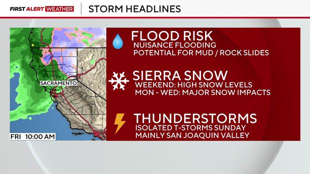
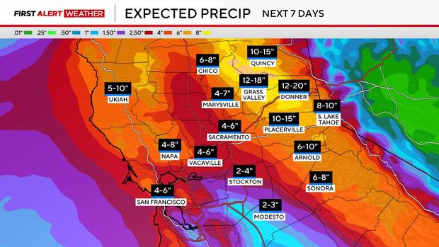
Rainfall totals from this storm could be anywhere from 2-4 inches for areas north of Interstate 80. The areas south of I-80 could get anywhere from 1/2-1 inch of rain.
The foothills and mountains could get between 3-6 inches, with some local areas getting up to 10 inches of rainfall.
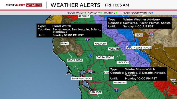
Minor travel issues due to the snow are anticipated from this storm as the snow level will likely be above pass level. However, the Sacramento office of the National Weather Service issued a Winter Storm Warning was for Lassen Park, Western Plumas County and the Northern Sierra starting Monday.
The El Dorado County Sheriff's Office issued an elevated avalanche warning in the Sierra backcountry Saturday due to this first storm.
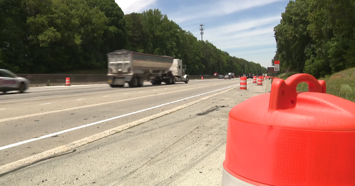
Drivers planning to head into the mountains can check the latest highway conditions, including whether chain controls are in effect, online.
Southerly winds arrived Saturday and are expected to continue through Monday. Gusts could get up to 35 mph, especially in exposed areas.
This storm is expected to bring the first measurable rain to the area since Jan. 3, when the area received 3/10's of an inch.
A flood watch was issued until 10 p.m. Sunday for Sacramento, San Joaquin, Solano and Stanislaus counties. A winter weather advisory is in effect in the Sierra until 4 a.m. Sunday.
Second storm arrives early next week
A second storm could add another 1-2 inches of rain to the Sacramento Valley and the San Joaquin Valley could get another 1/2-1 inch of rainfall.
The foothills and mountains could receive an additional 2-4 inches with some local areas getting as much as 7 inches.
Snow from this storm is anticipated to impact commutes. Areas above 5,000 feet could get anywhere from 6-18 inches of snow, with areas above 6,000 feet anticipated to get more than two feet.
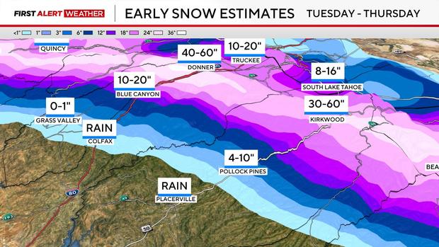
At the moment, this snowfall is looking to arrive late Monday through Wednesday.
However, forecast models are not consistent with timing and precipitation amounts and adjustments in the storm's timing along with precipitation amounts are likely.
Drivers should expect wet roads, slow commutes, minor ponding in low-lying areas and chain controls.
All rivers, streams and creeks are expected to rise sharply, but no river flooding is expected at this time.
Newsom pre-deploys resources
Gov. Gavin Newsom said Thursday the state has pre-deployed resources to help protect communities from the storms.
California is pre-deploying resources and thousands of boots on the ground throughout Northern California so we can be ready at a moment's notice to protect people," he said. "The best thing people can do now is to prepare and stay alert."
The state is paying close attention to recent burn scar areas, which pose a threat of mudslides and debris flows.
January totals
In early January, the California Department of Water Resources reported that the Phillips Station was at 91 percent of its average, whereas the entire state was at 108 percent of the average for early January.
But on Monday, the UC Berkeley Central Sierra Snow Lab reported it was on day 24 without measurable rain, making it the third longest stretch without precipitation since 1991. Only 2007 and 2022 had longer periods.
The snow lab reported it's received 1.5 inches of precipitation since Jan. 1, making it the seventh driest January so far.
The DWR will be conducting its second snow survey at the Phillips Station on Friday at 11 a.m.