Mid-week storm system to bring rain, strong winds, high fire danger to Northern California

Tuesday was another quiet, early fall day across Northern California with highs in the 70s and 80s. Enjoy the quiet weather before bigger changes arrive Wednesday and stick around through the end of the week.
Expect clear skies through the day on Tuesday before clouds increase by early Wednesday morning.
Mid-week storm
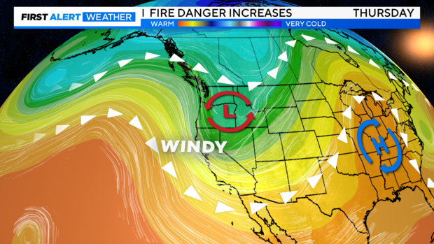
Our next storm system drops in from the Gulf of Alaska delivering scattered showers across Northern California as early as Wednesday morning.
This area of low pressure will produce a weak, quick-passing cold front as it moves in. The Sacramento Valley can expect to see showers develop as early as 6 a.m. before tapering off by the afternoon. Most showers will develop north of I-80, but we can't rule out a few passing showers toward the San Joaquin Valley by 10 a.m.
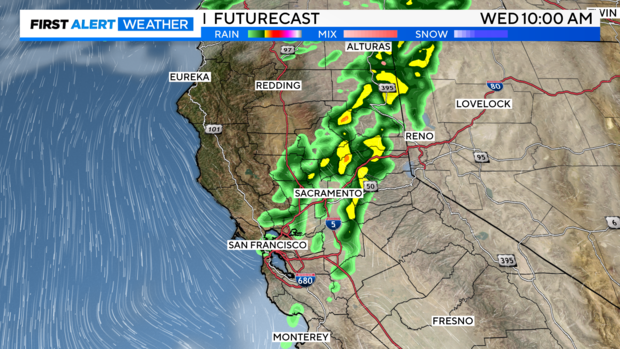
Showers and isolated thunderstorms begin to move to the east through Wednesday afternoon. As colder air fills in, we could see a light dusting of snow for areas above 6,000-feet in the Sierra, yet there won't be a lot of moisture left behind to see any significant impacts.
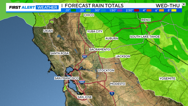
Precipitation amounts will be light with about 0.10'' of rain expected for most, with up to 0.25'' for the foothills and Sierra.
With lighter rainfall expected, the ground will remain mostly dry setting up elevated fire danger as we finish off the week.
Highs will drop as this system moves through with many in the 60s and 70s Wednesday through Friday.
High Fire Danger
As the low-pressure system begins to shift to the east side of the Sierra, this will increase northerly winds by Thursday evening.
Setting the stage for high fire risk through the end of the week and the start of the weekend.
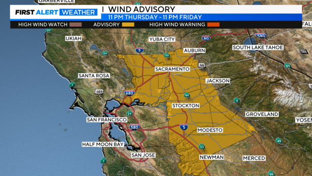
In the valley and northeast foothills, expect north of east winds of 15-25 MPH with gusts up to 35-45 MPH. In the Delta, northerly winds 20-30 MPH with gusts up to 55 MPH. The strongest winds are expected on Friday.
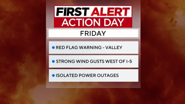
All of the ingredients will be in place for a fire to expand quickly if started with gusty north winds, low humidity, and dry fuels. A Red Flag Warning has been issued.
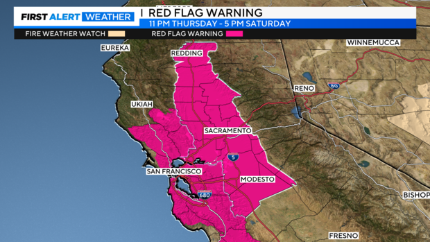
A Wind Advisory has also been issued for areas that will experience the strongest wind including the Sacramento Valley, San Joaquin Valley, and portions of the Delta and foothills.
PG&E has already announced the potential for power shutoffs (PSPS) from Thursday through Saturday spanning from the Bay Area to the foothills. Shutoffs expand on Friday including Yolo, El Dorado, Placer, Stanislaus, Yolo, and Tuolumne counties.
Make sure to take the steps to prepare now in case your power goes out.
Wind begins to taper by Saturday afternoon as our weather pattern turns calmer by the end of the weekend. Here are a few tips on what to do if the power goes out.
Looking Ahead
A quieter pattern rebuilds as we get closer to Sunday with less wind in the forecast. Highs this weekend in the low 80s.
Temperatures stay mild through next week with highs in the 70s to 80s. Very seasonable for this time of the year.
Models are beginning to catch on to another system by the middle of next week. It is right on track as late October usually brings our first storms of the season. Make sure to stay with the CBS Sacramento First Alert Weather team for any changes to the extended forecast.