Some evacuations downgraded for Pay Fire near Placerville; 77 acres burned
EL DORADO COUNTY – Some of the mandatory evacuations that were issued for a fire southeast of Placerville on Saturday afternoon were downgraded in the evening.
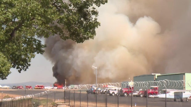
Cal Fire AEU said the fire, called the Pay Fire, is 77 acres with 5% containment as of 10:15 p.m. Firefighters had said it was spreading at a dangerous rate and structures were threatened.
"There was a firefighter in my yard as I was getting stuff and it looks like we are to be out of here," said Placerville resident Jared Noceti.
The fire was moving east toward the Placerville Airport along Country Club Drive, the El Dorado County Fire Protection District said.
"They were flying so low he got fire retardant on the plane and he had to duck under the wing so they're working hard," Penny Solano said as she and her husband were checking on their plane.
A spot fire was reported east of Texas Hil Road, forcing more evacuations, officials said.
The fire protection district said at 2:30 p.m. that multiple hangers were involved at the airport.
Evacuations
As of 10 p.m. Saturday, mandatory evacuations remain in place for Airport Road south of Goldman Lane, parts of the Placerville Airport, Big Barn Road to Texas Hill Road to Cedar Ravine Road, Paydirt Drive and Denim Court.
The evacuation order on the east side of Newtown Road, to include Parkway Drive, Ivy Knoll Drive to Learning Tree Road, Mining Brook Road and Still Meadow Road near the El Dorado Trail, was downgraded to a warning around 7:30 p.m.
Roads in evacuation warnings include Nugget Lane near Gingham Court near Nugget Lane, Barrett Drive, Country Club Drive near Duden Drive to Cedar Ravine Road, Airport Road from Goldman Lane to Broadway, and Broadway just west of Airport Road to Newtown Road. The areas east of Newtown Road, including Parkway Drive, Ivy Knoll Drive and Mining Brook Road are in evacuation warnings.
The latest warnings to be issued were for the Camino Heights area but that has since been lifted.
A temporary evacuation shelter has been established at the Placerville Library, located at 345 Fair Lane.
Animals can be taken to El Dorado County Animal Service located at 6435 Capitol Ave. in Diamond Springs.
An overnight shelter has been set up at Union Mine High School at 6530 Koki Lane in El Dorado.
All this information is available on the Perimeter Map.
Power outages
There are also power lines down near the area where the fire started, the protection district said. However, firefighters have not said what caused the fire.
The PG&E outage map shows about 170 customers lost power just minutes after 2:30 p.m. south of the Placerville Airport.
Nearly 1,800 customers also lost power around 3 p.m. This outage extended from the airport area to Placerville and on the north side of Highway 50 near Placerville Drive. It was then reduced to about 311 customers in the area of the evacuation orders and warnings.
Road closures
As of about 9:15 p.m., Airport Road is closed at Country Club Road and near Goldman Lane.
Big Barn Road is closed at Newtown Road. Texas Hill Road is closed at Big Barn Road.
Cedar Ravine Road is closed at Paydirt Drive and Texas Hill Road.


