Park Fire now one of the 5 largest wildfires ever in California; at least 209 homes destroyed
CHICO — Northern California's Park Fire has grown to become one of the largest wildfires in state history as evacuation orders continue to affect four counties — Butte, Tehama, Shasta and Plumas.
Cal Fire reported that containment remained at 18 percent as of Thursday morning. The Park Fire is the largest wildfire in the state this year and the fifth-largest wildfire in California history, burning 392,480 acres so far, Cal Fire reports.
The top four wildfires in California history are the 2020 August Complex (1,032,648 acres), the 2021 Dixie Fire (963,309 acres), the 2018 Mendocino Complex (459,123 acres) and the 2020 SCU Lightning Complex (396,625 acres).
Because so-called "complex fires" are made up of multiple smaller fires that merge and grow together, the Park Fire is the second-largest singular wildfire in state history, only behind the Dixie Fire, which affected the same four counties in addition to Lassen County.
The fire has scorched an area more than six times the size of the city of Sacramento. A Cal Fire firefighter said the flames were still spreading at a rate of 4,000 to 5,000 acres per hour on Monday. Most of the burn area has been in Tehama County with the flames spreading north toward Shasta County.
IN PHOTOS: Park Fire in Northern California
Cal Fire said the Park Fire was the result of suspected arson and ignited around 3 p.m. Wednesday in the Upper Bidwell Park area, about four miles northeast of Chico's city center, in Butte County.
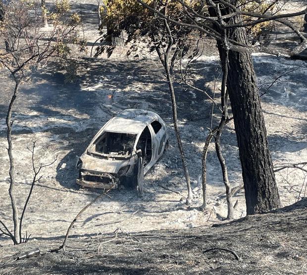
As of Wednesday, 434 structures have been destroyed while 39 have been damaged. In Butte County, 310 structures have been destroyed and 127 have been destroyed in Tehama County.
Billy See, Cal Fire incident commander, said Wednesday afternoon that 209 of the structures lost in the fire were single-family homes, with 154 destroyed in Butte County and 55 destroyed in Tehama County.
Of the structures inspected in Butte County as of Wednesday, there is a 68% survival rate for structures, See said.
As for the survival rate for structures in Tehama County, See said it was at 66% as of Wednesday.
The damage inspection team is about 80% completed with its assessment, Cal Fire said.
Butte County Sheriff Kory Honea said Friday afternoon that about 4,200 residents are under evacuation. The number was not yet clear for the other counties.
The town of Paradise, which was devastated in the 2018 Camp Fire, was issued an evacuation warning. Those warnings were lifted late Monday morning, officials announced.
An Alert California tower camera in the area captured a fire tornado, or firenado, near Chico early Thursday evening.
Arson suspect arrested
The Butte County District Attorney's Office announced Thursday they had arrested a man suspected of starting the fire. As detailed by the DA's office, a man was seen pushing a car that was on fire down into the gully near Alligator Hole in upper Bidwell Park -- allegedly spreading the flames that would become the Park Fire.
He was arrested Thursday and identified by the district attorney's office as Chico resident Ronnie Dean Stout II, 42. He was reportedly seen calmly leaving the area, trying to blend in with other people.
Alligator Hole is a popular area for people to cool off during the summer and is about six miles east of Chico's city plaza. Upper Bidwell Park is one of the largest municipal parks in the nation and is home to many hiking and biking trails, swimming holes and picnic areas.
Fire activity
Crews said Wednesday the fire is burning at multiple locations around the perimeter. They expected smoke to be more widespread with limited and late clearing.
Resources will be in the northeast section of the fire constructing fire lines next to the fire's edge and at strategic locations from the fire's edge, Cal Fire said.
There are reports of active fires within the Antelope Creek drainage and Mill Creek drainage.
Evacuation orders and shelters
Butte County
Evacuations were first issued in Butte County. Several zones stretching northeast from just east of Bidwell Park up Highway 32 to the Butte Meadows and Jonesville areas are under mandatory evacuation orders. It includes Cohasset Ridge and Keefer Ridge.
Several evacuation warnings were lifted on Wednesday, including around the Chico airport and the south Cohasset area. Warnings are still in place for areas such as Forest Ranch, Stirling City and the Bald Mountain areas.
An evacuation shelter in Butte County was set up at Neighborhood Church at 2801 Notre Dame Blvd. in Chico. A second evacuation shelter is open at the Butte County Fairgrounds at 199 E. Hazel St. in Gridley.
A shelter for small animals is operating at 2279 Del Oro, in Oroville. Large animals can be taken to Camelot Equestrian Park at 1985 Clark Rd. in Oroville.
In Butte County, Cohasset Road was closed at Rock Creek, and Upper Park Road was closed at Wildwood, Cal Fire said. Additionally, Highway 32 is closed from Bruce Road in Chico to Highway 36.
Butte County residents can view a live evacuation map here to see the exact zones.
Tehama County
Tehama, Shasta and Plumas County residents can view a live evacuation map here.
In Tehama County, nearly the entire eastern side of the county, from the southern border to the northern border, is under mandatory evacuation orders. This continues from the Cohasset area near the Butte border through the Ishi Wilderness and Tehama Wildlife Area, through Highway 36 to the Shasta County border, east of Highway 99.
A few zones are under evacuation warnings on the east side of Highway 99 and west of the mandatory zones, stretching from the Butte County border north to the Shasta County border. A few zones in the easternmost part of the county, where Highways 36 and 32 meet, are also under evacuation warnings.
An evacuation shelter in Tehama County is operating in Los Molinos at 7980 Sherwood Blvd.
Shasta County
In Shasta County, several zones between the Manton and Shingletown areas and stretching west and east on the south side of Highway 44 are also under mandatory evacuation orders.
Dozens of zones on the north side of Highway 44 are under evacuation warnings. The Lassen Volcanic National Park area is also under an evacuation warning.
A temporary shelter point for Shasta evacuees is set up at the Dollar General on Highway 44 in Shingletown, the sheriff's office said. Another one will be set up at Bella Vista Elementary School at 22661 Old Alturas Rd.
Plumas County
An area of Plumas County extending from the west side of Lake Almanor and Highway 36 down to the Grizzly Creek bridge along the Feather River Highway is under an evacuation warning. This is east of the burn area.
Federal assistance
Shasta County declared an emergency on Wednesday, July 31, a week after the fire ignited two counties south.
A local emergency was declared in Butte County the day after the fire started, allowing the county to request more resources from the state. Ahead of the local emergency being declared, Newsom secured a Fire Management Assistance Grant from FEMA to help with the state's response to the fire.
Then, two days after the fire sparked, California Gov. Gavin Newsom proclaimed a state of emergency in Butte and Tehama counties.
"We are using every available tool to protect lives and property as our fire and emergency response teams work around the clock to combat these challenging fires," Newsom said in a July 26 statement. "Stay safe and remain alert for instructions from local authorities as dangerous fire weather conditions continue."
Newsom then secured federal assistance for Tehama County on Saturday night.
Butte County has had a very busy fire season this summer. The Thomspon Fire in the Oroville area recently scorched more than 3,700 acres, forced tens of thousands of people from their homes, and destroyed dozens of structures, including houses.
The day after the Thompson Fire started, the Grubbs Fire just south of that in Palermo was much smaller but also forced evacuations.
In mid-July, the Railbridge Fire, just south of Palermo, burned 130 acres, forced evacuations, destroyed or damaged several structures and injured at least one person.
Back in June, the Apache Fire, which burned in the same general area near Oroville and Palermo, scorched nearly 700 acres and forced its own round of evacuations.
Nearly two weeks before the Apache Fire, the Junes Fire burned nearly 1,100 acres in Palermo and also forced people from their homes.
The Park Fire is burning just west of where the destructive Camp and Dixie fires happened in Butte County.
The 2021 Dixie Fire burned nearly 1 million acres across Butte, Plumas, Shasta, Lassen and Tehama counties.
Further back in 2018, the Camp Fire burned more than 150,000 acres in Butte County, nearly destroying the town of Paradise. It is the deadliest fire in state history, killing 85 people.