Major Northern California winter storm brings more heavy snow, rain to end week

After a chilly and dry start to the week, Northern California's weather pattern is about to change. The next winter storm is set to bring major impacts to commuters and holiday travelers by the end of the week with heavy rain, snow and gusty winds.
A First Alert Action Day has been declared for Thursday by the CBS Sacramento First Alert Weather team, which is when the main event of the storm arrives.
Showers arrived late Wednesday
Wednesday was a cloudy and mainly dry day across the Sacramento and San Joaquin Valleys. The Bay Area caught the first initial wave of the storm as it dives toward Southern California.
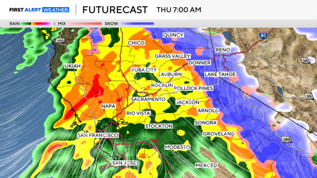
That direction changed by the evening. Showers began to increase west to east after 9 p.m. Wednesday. Showers then became widespread by Thursday morning with areas of heavy rain and snow.
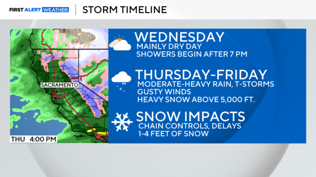
Soaking rain, heavy Sierra snow Thursday
The main event arrived Thursday morning as rounds of moderate-heavy rain and snow filled Northern California.
Thursday's commute was challenging with heavy rain falling, gusty winds up to 50 miles per hour and ponding on roads from backed-up storm drains.
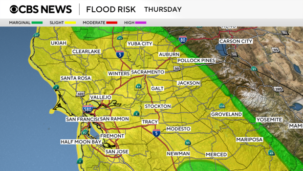
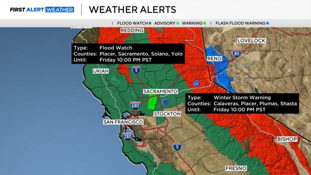
A Flood Watch was issued across the Sacramento Valley and adjacent foothills starting Wednesday evening. Moderate to heavy rain will create slick roads, mud and rock slides in the foothills and help raise flows in local waterways creating minor flooding issues.
In the Northern Sierra, travel will become difficult quickly. Snow levels begin around 4,000 feet before rising to 5,000 to 6,000 feet in elevation by Thursday afternoon.
Heavy snow, combined with gusty southerly winds up to 70 miles per hour, will lead to very difficult mountain travel conditions. Chain controls, extended closures and near-zero visibility are expected at times.
A Winter Storm Warning has been issued for elevations above 4,500 feet through Friday evening.
Make sure to check road conditions before you go and try to avoid Sierra travel, if possible.
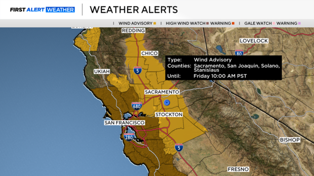
Wind will be another big story of this storm with strong, gusty winds throughout the day on Thursday with the peak of the winds arriving in the morning. A Wind Advisory has been issued through Friday morning.
Isolated thunderstorms can't be ruled out either as the main frontal band moves in. Storms that develop would increase rain accumulation quickly and create strong winds.
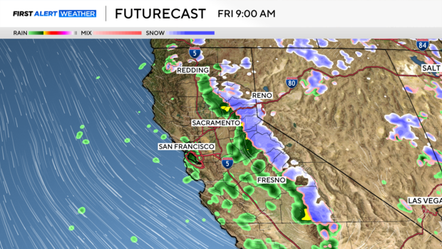
After noon, there was some breaks in activity. Showers became scattered through Thursday evening and into the day on Friday. With more dry time for any Valentine's Day plans in the evening across the valley.
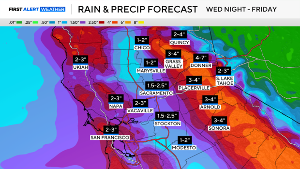
Several inches of rain
Showers will begin to taper off Friday afternoon and evening, clearing just in time for the weekend.
We are expecting 1 to 2.5 inches of rain across the valley floor with up to 6 inches of precipitation across portions of the foothills and Sierra.
With more excessive rain in the forecast, make sure to keep an eye out for any flooded roads or mud and rock slides — never drive through them.
Tough travel in the Sierra
Traveling across Sierra passes will be difficult to impossible at times. Snowfall rates will be up to 1-2 inches an hour during the day Thursday and early Friday.
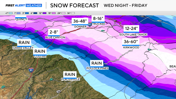
The heaviest snow will accumulate above 5,000 feet in elevation with 1-5 feet of snow expected across mountain passes and peaks.
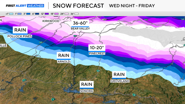
Ski resorts will appreciate the fresh powder, but drivers need to be prepared heading up to the slopes.
Weekend impacts
Friday will be a slick day for travel across the Sierra as plows clear roads. Showers taper off by Friday evening and by Saturday roads will be much easier to use.
In the valley, little to no impacts by Saturday as the sky clears.

The weekend will bring a dry day on Saturday with a chance of a few light showers on Sunday across the northern end of the valley and foothills. Most will stay dry, but some may catch a light sprinkle through the afternoon.
A dry, warmer pattern returns next week. Make sure to stay with the CBS Sacramento First Alert Weather team for updates.